Hutt Central

Last updated

Hutt Central
Suburb of Lower Hutt City
Lower Hutt Town Hall and Council building 2021-09-25 1.jpg
The Lower Hutt town hall and council building is in Hutt Central.
Hutt Central
Country New Zealand
CityLower Hutt City
Electoral wardCentral
Area
  Land236 ha (583 acres)
Population
 (June 2021) [1]
  Total4,350
Harbour View Boulcott Epuni
Melling
Pfeil oben.svg
Pfeil links.svgHutt CentralPfeil rechts.svg
Pfeil unten.svg
Fairfield
Alicetown Woburn Waterloo

Hutt Central, a suburb of the city of Lower Hutt in New Zealand, forms part of the urban area of greater Wellington. It includes the Lower Hutt CBD.

Contents

It includes Dowse Art Museum, Lower Hutt War Memorial Library and Lower Hutt Central Fire Station.

Demographics

Hutt Central, comprising the statistical areas of Hutt Central North and Hutt Central South, covers 2.36 km2 (0.91 sq mi). [2] It had an estimated population of 4,350 as of June 2021, with a population density of 1,843 people per km2.

Historical population
YearPop.±% p.a.
20063,738    
20133,954+0.81%
20184,176+1.10%
Source: [3]

Hutt Central had a population of 4,176 at the 2018 New Zealand census, an increase of 222 people (5.6%) since the 2013 census, and an increase of 438 people (11.7%) since the 2006 census. There were 1,539 households. There were 2,016 males and 2,157 females, giving a sex ratio of 0.93 males per female, with 651 people (15.6%) aged under 15 years, 756 (18.1%) aged 15 to 29, 1,860 (44.5%) aged 30 to 64, and 903 (21.6%) aged 65 or older.

Ethnicities were 69.1% European/Pākehā, 7.7% Māori, 3.4% Pacific peoples, 25.1% Asian, and 2.6% other ethnicities (totals add to more than 100% since people could identify with multiple ethnicities).

The proportion of people born overseas was 30.3%, compared with 27.1% nationally.

Although some people objected to giving their religion, 45.1% had no religion, 40.0% were Christian, 5.7% were Hindu, 1.1% were Muslim, 1.6% were Buddhist and 1.8% had other religions.

Of those at least 15 years old, 1,173 (33.3%) people had a bachelor or higher degree, and 408 (11.6%) people had no formal qualifications. The employment status of those at least 15 was that 1,695 (48.1%) people were employed full-time, 471 (13.4%) were part-time, and 120 (3.4%) were unemployed. [3]

Individual statistical areas
NamePopulationHouseholdsMedian ageMedian income
Hutt Central North95139636.6 years$38,300 [4]
Hutt Central South3,2251,14347.3 years$38,700 [5]
New Zealand37.4 years$31,800

Education

Public schools

Eastern Hutt School is a co-educational state primary school for Year 1 to 6 students, [6] [7] with a roll of 631 as of November 2021. [8]

Intermediate education is available in nearby Hutt Intermediate School in Woburn. [9]

Hutt Valley High School is a co-educational state secondary school for Year 9 to 13 students, [10] with a roll of . [11] It was founded in 1926. [12]

Independent schools

Sts Peter and Paul School is a co-educational state-integrated Catholic primary school for Year 1 to 8 students, [13] [14] with a roll of 472 as of November 2021. [15]

Chilton St James School is a private girls' school for Year 1 to 13 students, [16] with a roll of 319. [17] It was founded in 1918. [18]

Sacred Heart College is a girls' state-integrated Catholic school for Year 9 to 13 students, [19] with a roll of 796. [20] It was founded in 1912. [21]

St Bernard's College is a boys' state-integrated Catholic school for Year 7 to 13 students, [22] with a roll of 647. [23] It was founded in 1946. [24]

Related Research Articles

Trentham, New Zealand Suburb in Wellington, North Island, New Zealand

Trentham is the most populous suburb of Upper Hutt, a city in the Wellington region of New Zealand. The suburb is located in a widening of the Hutt Valley, five kilometres to the southwest of the Upper Hutt city centre.

Richmond, New Zealand Town in Tasman, New Zealand

Richmond is a town and the seat of the Tasman District Council in New Zealand. It lies 13 kilometres (8 mi) south of Nelson in the South Island, close to the southern extremity of Tasman Bay / Te Tai-o-Aorere. The town, first settled by Europeans in 1842, was named in 1854 after the town of Richmond on Thames near London. The town has an estimated population of 18,000 as of June 2021.

Silverstream Suburb of Upper Hutt in New Zealand

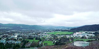
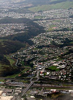
Silverstream is a suburb of Upper Hutt in New Zealand, just under 7 km south-west of the Upper Hutt CBD. It is in the lower (southern) part of the North Island of New Zealand at the southern end of Upper Hutt, close to the Taitā Gorge, which separates Upper Hutt from Lower Hutt. The area is sited at the mouth of a small valley formed by the Wellington Region's tectonic activity and, in part, by Hull's Creek, which discharges into the Hutt River.

Miramar, New Zealand Suburb of Wellington City in New Zealand

Miramar is a suburb of Wellington, New Zealand, south-east of the city centre. It is on the Miramar Peninsula, directly east of the isthmus of Rongotai, the site of Wellington International Airport.

Napier Hill Suburb of Napier in New Zealand

Napier Hill is a limestone outcrop and suburb rising above the lowland districts of the city of Napier on New Zealand's North Island.

Hokowhitu is a riverside suburb of the New Zealand city of Palmerston North, with some of the highest property values in the city.

Kilbirnie, New Zealand Suburb of Wellington City in New Zealand

Kilbirnie is a suburb of Wellington in New Zealand, 3 kilometres (1.9 mi) to the south-east of the city centre. Travellers can reach Kilbirnie from the Wellington central business district either via the Mount Victoria Tunnel and Hataitai; over Mount Victoria; or around the coast.

Waitangirua is a suburb of Porirua City approximately 22km north of Wellington in New Zealand.

Cannons Creek, New Zealand Suburb of Porirua City near Wellington in New Zealand

Cannons Creek is a suburb of Porirua City approximately 22km north of Wellington in New Zealand.

Onekawa is a suburb of the city of Napier, in the Hawke's Bay Region of the eastern North Island of New Zealand.

Bethlehem is a suburb of Tauranga in New Zealand's North Island. Originally a small independent town, it has now been absorbed by Tauranga and comprises a number of subdivisions including Bethlehem Heights, Sterling Gate, La Cumbre, Saint Andrews, and Mayfield.

Elderslea is a suburb of Upper Hutt located in the lower North Island of New Zealand, near Upper Hutt Central.

Upper Hutt Central Suburb in Upper Hutt, North Island, New Zealand

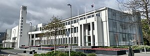
Upper Hutt Central is the commercial and geographic focal point of Upper Hutt city, located in the lower North Island of New Zealand.

Tauranga South is a suburb of Tauranga, on New Zealand's North Island. It is located south-east of Judea, north-east of Gate Pa and south-west of Tauranga Central.

Nelson South is an inner suburb of Nelson, New Zealand. It lies to the southwest of Nelson city centre, between it and Bishopdale, close to the foot of The Grampians. The main inland route to Stoke, New Zealand, Waimea Road, is Nelson South's main road.

Gonville is a residential suburb of Whanganui, New Zealand. It is under the local governance of the Whanganui District Council.

Western Heights is a suburb of Rotorua in the Bay of Plenty Region of New Zealand's North Island.

St Johns Hill is a suburb of Whanganui, in the Whanganui District and Manawatū-Whanganui region of New Zealand's North Island.

College Estate Suburb of Whanganui in New Zealand

College Estate is a suburb of Whanganui, in the Whanganui District and Manawatū-Whanganui region of New Zealand's North Island.

Masterton West is a suburb of Masterton, a town on New Zealand's North Island.

References

  1. "Population estimate tables - NZ.Stat". Statistics New Zealand . Retrieved 22 October 2021.
  2. "ArcGIS Web Application". statsnz.maps.arcgis.com. Retrieved 11 June 2021.
  3. 1 2 "Statistical area 1 dataset for 2018 Census". Statistics New Zealand. March 2020. Hutt Central North (244300) and Hutt Central South (244800).
  4. 2018 Census place summary: Hutt Central North
  5. 2018 Census place summary: Hutt Central South
  6. "Eastern Hutt School Official School Website". easternhutt.school.nz.
  7. "Eastern Hutt School Education Review Office Report". ero.govt.nz. Education Review Office.
  8. "Eastern Hutt School Ministry of Education School Profile". educationcounts.govt.nz. Ministry of Education.
  9. "Find schools in Lower Hutt City". educationcounts.govt.nz. Ministry of Education.
  10. "Hutt Valley High School Education Review Office Report". ero.govt.nz. Education Review Office.
  11. "Hutt Valley High School Ministry of Education School Profile". educationcounts.govt.nz. Ministry of Education.
  12. "Hutt Valley High School Official School Website". hvhs.school.nz.
  13. "Sts Peter and Paul School Official School Website". stpeterpaul.school.nz.
  14. "Sts Peter and Paul School Education Review Office Report". ero.govt.nz. Education Review Office.
  15. "Sts Peter and Paul School Ministry of Education School Profile". educationcounts.govt.nz. Ministry of Education.
  16. "Chilton St James School Education Review Office Report". ero.govt.nz. Education Review Office.
  17. "Chilton St James School Ministry of Education School Profile". educationcounts.govt.nz. Ministry of Education.
  18. "Chilton St James School Official School Website". chilton.school.nz.
  19. "Sacred Heart College Education Review Office Report". ero.govt.nz. Education Review Office.
  20. "Sacred Heart College Ministry of Education School Profile". educationcounts.govt.nz. Ministry of Education.
  21. "Sacred Heart College Official School Website". sacredheartcollege.school.nz.
  22. "St Bernard's College Education Review Office Report". ero.govt.nz. Education Review Office.
  23. "St Bernard's College Ministry of Education School Profile". educationcounts.govt.nz. Ministry of Education.
  24. "St Bernard's College Official School Website". sbc.school.nz.

Coordinates: 41°12′32″S174°54′22″E / 41.208764°S 174.905975°E / -41.208764; 174.905975