Woburn, New Zealand

Last updated

Woburn
Suburb of Lower Hutt City
Hutt Railway Workshops, Woburn. The pattern shop, 1930 ATLIB 290270.png
Hutt Railway Workshops pattern shop in 1930
Woburn, New Zealand
Country New Zealand
CityLower Hutt City
Electoral wardCentral / Harbour
Established1840s
Area
  Land0.62 ha (1.53 acres)
Population
 (June 2021) [1]
  Total1,850
Train station(s) Woburn Railway Station
Lower Hutt CBD Waterloo
Pfeil oben.svg
Pfeil links.svgWoburnPfeil rechts.svg
Pfeil unten.svg
Waiwhetū
Ava Moera

Woburn is a suburb of Lower Hutt, Wellington situated at the bottom of the North Island of New Zealand.

Contents

Henry Petre farmed the area in the 1840s and named the area after the Duke of Bedford's estate, Woburn Abbey. Petre's farm was later taken over by Daniel and Harriet Riddiford, whose descendants built a large home there, with the land being gradually subdivided. [2] Riddiford Street in Lower Hutt commemorates them.

Demographics

Woburn statistical area covers 0.62 km2 (0.24 sq mi). [3] It had an estimated population of 1,850 as of June 2021, [1] with a population density of 2,984 people per km2.

Historical population
YearPop.±% p.a.
20061,734    
20131,692−0.35%
20181,752+0.70%
Source: [4]
The Prince Edward Cinema, since demolished Former Prince Edward Cinema Woburn, Lower Hutt (4420441341).jpg
The Prince Edward Cinema, since demolished

Woburn had a population of 1,752 at the 2018 New Zealand census, an increase of 60 people (3.5%) since the 2013 census, and an increase of 18 people (1.0%) since the 2006 census. There were 660 households. There were 831 males and 921 females, giving a sex ratio of 0.9 males per female. The median age was 43.1 years (compared with 37.4 years nationally), with 279 people (15.9%) aged under 15 years, 321 (18.3%) aged 15 to 29, 849 (48.5%) aged 30 to 64, and 300 (17.1%) aged 65 or older.

Ethnicities were 71.9% European/Pākehā, 8.9% Māori, 2.6% Pacific peoples, 23.6% Asian, and 2.2% other ethnicities (totals add to more than 100% since people could identify with multiple ethnicities).

The proportion of people born overseas was 30.0%, compared with 27.1% nationally.

Although some people objected to giving their religion, 45.0% had no religion, 40.8% were Christian, 5.8% were Hindu, 0.7% were Muslim, 1.2% were Buddhist and 2.1% had other religions.

Of those at least 15 years old, 561 (38.1%) people had a bachelor or higher degree, and 156 (10.6%) people had no formal qualifications. The median income was $41,300, compared with $31,800 nationally. The employment status of those at least 15 was that 738 (50.1%) people were employed full-time, 243 (16.5%) were part-time, and 45 (3.1%) were unemployed. [4]

Related Research Articles

Eastbourne, New Zealand Place in New Zealand

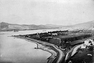
Eastbourne is a suburb of Lower Hutt, a part of Wellington, New Zealand. Lying beside the sea, it is a popular local tourist destination via car from Petone or from ferry crossings from central Wellington. An outer suburb, it lies on the eastern shore of Wellington Harbour, five kilometres south of the main Lower Hutt urban area and directly across the harbour from the Miramar Peninsula in Wellington city. A narrow exposed coastal road connects it with the rest of Lower Hutt via the Eastern Bays and the industrial suburb of Seaview. It is named for Eastbourne in England, another seaside town known as a destination for day-trips.

Alicetown is a central suburb of Lower Hutt located at the bottom of the North Island of New Zealand.

Belmont, Wellington Suburb of Lower Hutt City in New Zealand

Belmont, a suburb of Lower Hutt, to the north of Wellington in the North Island of New Zealand, lies on the west bank of the Hutt River, on State Highway 2, the Wellington-Hutt main road, and across the river from the centre of Lower Hutt.

Waterloo is an eastern suburb of Lower Hutt, Wellington. It is named after the Battle of Waterloo won by the Duke of Wellington in 1815.

Moera Suburb of Lower Hutt City in New Zealand

Moera, a suburb of the city of Lower Hutt in New Zealand, forms part of the urban area of greater Wellington.

Ebdentown, a suburb of Upper Hutt located in the lower North Island of New Zealand, near Upper Hutt Central.

Hutt Central, a suburb of the city of Lower Hutt in New Zealand, forms part of the urban area of greater Wellington. It includes the Lower Hutt CBD.

Kelson, New Zealand Suburb of Hutt City in New Zealand

Kelson is a suburb of Lower Hutt in Wellington, New Zealand. It is situated on the western hills of the Hutt Valley. To the west of the suburb lies the Belmont Regional Park, while to the east runs the Hutt River and State Highway 2.

Boulcott is a central suburb of Lower Hutt City situated in the south of the North Island of New Zealand. The suburb lies about a kilometre north-east of the Lower Hutt CBD.

Tirohanga is a suburb of Lower Hutt City situated at the bottom of the North Island of New Zealand. The suburb is located on the western side of the Hutt River and State Highway 2.

Manor Park, a northern suburb of Lower Hutt City, lies in the south of the North Island of New Zealand. The suburb separates the western bank of the Hutt River from State Highway 2.

Waiwhetū Suburb of Lower Hutt City in New Zealand

Waiwhetū is an eastern suburb of Lower Hutt in the Wellington Region situated in the south of the North Island of New Zealand.

Maungaraki is a suburb of Lower Hutt City situated at the bottom of the North Island of New Zealand. The suburb is located on the western hills of the Hutt Valley with access to the area via State Highway 2 and offers extensive views of Wellington harbour and Matiu/Somes Island. It contains the largest suburban development on the Hutt Valley's western escarpment that runs along the Wellington Fault.

Gracefield is an industrial suburb of Lower Hutt City, located at the bottom of the North Island of New Zealand.

Korokoro, New Zealand Suburb of Lower Hutt City in New Zealand

Korokoro, a suburb of Lower Hutt City, lies in the south of the North Island of New Zealand. The suburb occupies part of the western hills of the Hutt Valley; its eastern slopes overlook Petone and the Wellington harbour.

Parkway, New Zealand Suburb of Lower Hutt City in New Zealand

Parkway is a suburb of Wainuiomata, part of Lower Hutt city situated in the lower North Island of New Zealand.

Glendale is a suburb of Wainuiomata, part of Lower Hutt city situated in the lower North Island of New Zealand.

Arakura is a suburb of Wainuiomata, part of Lower Hutt city situated in the lower (southern) North Island of New Zealand.

Hutt Valley District Health Board

The Hutt Valley District Health Board is a district health board with the focus on providing healthcare to the cities of Lower Hutt and Upper Hutt in New Zealand.

Pipitea, New Zealand Suburb of Wellington City in New Zealand

Pipitea is a central suburb of Wellington, in the Wellington region of New Zealand's North Island.

References

  1. 1 2 "Population estimate tables - NZ.Stat". Statistics New Zealand . Retrieved 22 October 2021.
  2. Te Ara: The Encyclopaedia of New Zealand - Hutt Valley - central and west Retrieved: 10 January 2009
  3. "ArcGIS Web Application". statsnz.maps.arcgis.com. Retrieved 12 June 2021.
  4. 1 2 "Statistical area 1 dataset for 2018 Census". Statistics New Zealand. March 2020. Woburn (245300). 2018 Census place summary: Woburn

Coordinates: 41°13′S174°54′E / 41.217°S 174.900°E / -41.217; 174.900