The Historic Places Act 1954 was an act of the New Zealand Parliament. It established the New Zealand Historic Places Trust for the purpose of preserving, marking and recording places of historic interest in New Zealand.

Tiritiri Matangi Lighthouse, also known as Tiritiri Lighthouse, is a lighthouse on Tiritiri Matangi, an island in the Hauraki Gulf 28 km north of Auckland in the North Island of New Zealand. It is owned and operated by Maritime New Zealand. It is considered the best-preserved lighthouse complex in the country, and is the oldest lighthouse in New Zealand still in operation. It was once the most powerful lighthouse in the Southern Hemisphere.

Cape Egmont Lighthouse is a lighthouse at Cape Egmont in the Taranaki Region of the North Island of New Zealand. It is owned and operated by Maritime New Zealand. The light was manufactured by Simpson & Co., Pimlico, London, in 1864 and erected on Mana Island to the north west of Porirua in 1865, but it was sometimes confused with the Pencarrow Head light at the entrance to Wellington Harbour and in 1877 the light was dismantled and moved to Cape Egmont.

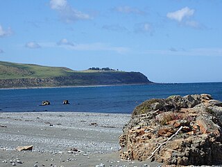
The Kātiki Point Lighthouse, also known as Moeraki Lighthouse, shone for the first time in 1878, following several accidents on the dangerous reefs around the area, to make the area safer for ships that sailed past on their way to Port Chalmers, Dunedin. The lighthouse was built between the settlements of Moeraki and Kātiki, on the tip of the Moeraki Peninsula, which is known as Kātiki Point or Moeraki Point.

Baring Head Lighthouse is a concrete lighthouse at Baring Head in the Wellington Region of the North Island of New Zealand, with an LED beacon powered by mains electricity. It is owned and operated by Maritime New Zealand, and can be accessed via walking tracks in the southern area of the East Harbour Regional Park, south of Wainuiomata.
The following lists events that happened during 1859 in New Zealand.

Nugget Point Lighthouse is a lighthouse at Nugget Point in the Otago region of the South Island of New Zealand. It is owned and operated by Maritime New Zealand.

Mokohinau Islands Lighthouse is a lighthouse on Burgess Island, one of the Mokohinau Islands, which lie off the northeast coast of the North Island of New Zealand. It is owned and operated by Maritime New Zealand. The lighthouse sits at the entrance to the Hauraki Gulf as the landfall light for vessels approaching Auckland from the north and northeast.

Point Clark Lighthouse is located on in a beach community, Point Clark, Ontario, near a point that protrudes into Lake Huron. Built between 1855 and 1859 under the instructions of the Board of Works, Canada West, it is one of the few on the Great Lakes to be made primarily from stone. It is one of the Imperial Towers, a group of six nearly identical towers built by contractor John Brown for the "Province of Canada" on Lake Huron and Georgian Bay, all completed by 1859. The location for the Point Clark lighthouse was selected to warn sailors of the shoals (sandbars) 2 miles (3.2 km) off the Lake Huron coast. It is still functioning as an automated light. A restoration that eventually exceeded $2.3 million started in 2011 and the facility reopened for tourism in June 2015.
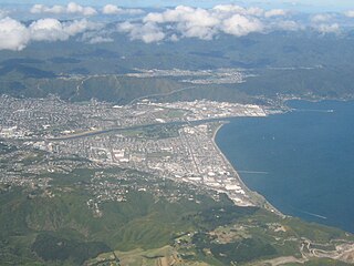
Lower Hutt is a city in the Wellington Region of New Zealand. Administered by the Hutt City Council, it is one of the four cities that constitute the Wellington metropolitan area.
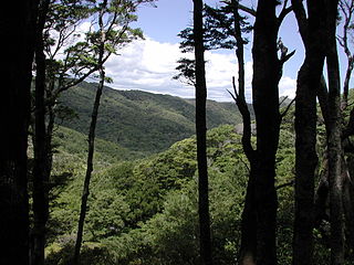
East Harbour Regional Park is a regional park stretching from Baring Head along the east side of the Wellington Harbour along the east side of Eastbourne. It is located in Lower Hutt City, in the Wellington Region of New Zealand's North Island.
Baring Head is a headland, located between Wellington Harbour and Palliser Bay at the southern end of the North Island of New Zealand. It marks the southern end of Fitzroy Bay.

Mary Jane Bennett was the first official lighthouse keeper in New Zealand, and the only woman to ever hold the role.

Pencarrow Head, also known as Pencarrow, is a headland in the Wellington Region of New Zealand and the name of the surrounding area, which was derived from Pencarrow, the family home of New Zealand Company director, Sir William Molesworth. The name is Cornish and formed from Pen which translates to English as head and Carrow which is a valley.

The Dog Island Lighthouse on Dog Island in Foveaux Strait is New Zealand's tallest lighthouse, and one of its oldest. It is notable for its masonry construction, and is a work example by an engineer who was prominent at the time. The lighthouse employed the first revolving beam in New Zealand, and the unique original light apparatus was in use for 60 years. Dog Island Lighthouse is one of the most distinct lighthouses in New Zealand, with only two others having stripes painted on them for better visibility at daytime. The lighthouse is registered by Heritage New Zealand as a Category I structure, and the adjacent lighthouse keepers cottage has a Category II registration. Originally operated by three lighthouse keepers, the structure has since 1989 been remote controlled from Maritime New Zealand's Wellington office, with Dog Island since having been uninhabited. Dog Island Lighthouse has twice featured on New Zealand stamps.

Boulder Bank Lighthouse is a decommissioned 19th century lighthouse located near the Port Nelson end of the Boulder Bank. It was New Zealand's second permanent lighthouse.

The Grand Harbour Lighthouse was a Canadian lighthouse marking the entrance to Grand Harbour, Grand Manan, New Brunswick. It was built and first lit in 1879 and was decommissioned in 1963. It was severely damaged in the Groundhog Day gale of 1976 and destroyed by a gale in November 2013.

The Stephens Island / Takapourewa lighthouse is one of New Zealand most powerful lights with a range of 18 nautical miles. Perched 183 metres (600 ft) up, on top of Stephens Island, it guards Cook Strait and Tasman Bay / Te Tai-o-Aorere, at the top of the South Island / Te Wai Pounamu.The light flashes white once every six seconds from a white cast iron tower.

Bean Rock Lighthouse is a lighthouse situated at the end of a reef in the Waitematā Harbour in Auckland, New Zealand. It is the only remaining example in New Zealand of a wooden cottage-style lighthouse, and it is one of only a few remaining worldwide. It is also the oldest wooden lighthouse and only wave-washed tower in New Zealand. It is owned, operated and maintained by Ports of Auckland.

The Cape Foulwind Lighthouse is a lighthouse that is located at Cape Foulwind, 11 km (7 mi) west of the town of Westport on the West Coast of New Zealand's South Island. Perched 70 metres (230 ft) above the Tasman Sea, the light guides vessels along the Buller coast, and is one of the most accessible lighthouses in the country. The LED light flashes white once every 12 seconds and has a range 10 nautical miles. It is a Category 2 heritage listed structure.