Mokohinau Islands Lighthouse

Last updated

Mokohinau Islands Lighthouse
Mokohinau Islands lighthouse 25 September 1902.jpg
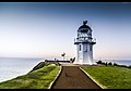
The lighthouse, 25 September 1902
Mokohinau Islands Lighthouse
Location Mokohinau Islands
North Island
New Zealand
Coordinates 35°54′23″S175°06′54″E / 35.9063°S 175.1149°E / -35.9063; 175.1149 Coordinates: 35°54′23″S175°06′54″E / 35.9063°S 175.1149°E / -35.9063; 175.1149
Tower
Constructed1883 [1]
Constructionstone tower
Automated1980
Height14 metres (46 ft)
Shapecylindrical tower with balcony and lantern
Markingswhite tower, black balcony
Power sourcesolar power  OOjs UI icon edit-ltr-progressive.svg
Light
First lit1883
Focal height122 metres (400 ft)
Range19 nautical miles (35 km; 22 mi)
Characteristic Fl W 10s.

Mokohinau Islands Lighthouse is a lighthouse on Burgess Island, one of the Mokohinau Islands, which lie off the northeast coast of the North Island of New Zealand. It is owned and operated by Maritime New Zealand. [2] The lighthouse sits at the entrance to the Hauraki Gulf as the landfall light for vessels approaching Auckland from the north and northeast. [3]

Contents

The lighthouse was built in 1883 and first lit during June of that year. Its isolated position, approximately 50 km northeast of Cape Rodney makes it one of the most distant lighthouses from the mainland.

During World War II, the lighthouse was turned off as the German destroyer suspected to be in the area laying mines. [4] The lighthouse was not relit until 1947. [5]

In 1980, the lighthouse was fully automated and the lighthouse keepers were withdrawn. The lighthouse is now monitored remotely from Wellington. The white light flashes every 10 seconds and can be seen for 19 nautical miles (35 km). [3]

See also

Related Research Articles

<span class="mw-page-title-main">Great Barrier Island</span>

Great Barrier Island lies in the outer Hauraki Gulf, New Zealand, 100 kilometres (62 mi) north-east of central Auckland. With an area of 285 square kilometres (110 sq mi) it is the sixth-largest island of New Zealand and fourth-largest in the main chain. Its highest point, Mount Hobson, is 627 metres (2,057 ft) above sea level. The local authority is the Auckland Council.

<span class="mw-page-title-main">Rangitoto Island</span> Island in New Zealand

Rangitoto Island is a volcanic island in the Hauraki Gulf near Auckland, New Zealand. The 5.5 km (3.4 mi) wide island is a symmetrical shield volcano cone capped by central scoria cones, reaching a height of 260 m (850 ft). Rangitoto is the youngest and largest of the approximately 50 volcanoes of the Auckland volcanic field, having erupted in two phases about 620 and 600 years ago and covering an area of 2,311 ha. It is separated from the mainland of Auckland's North Shore by the Rangitoto Channel. Since World War II, it has been linked by a causeway to the much older, non-volcanic Motutapu Island.

<span class="mw-page-title-main">New Zealand storm petrel</span> Species of bird

The New Zealand storm petrel is a small seabird of the family Oceanitidae. Thought to be extinct since 1850, a series of sightings from 2003 to the present indicates the presence of a previously unknown colony. As of 2010, it is ranked on the IUCN Red List as critically endangered.

<span class="mw-page-title-main">Waiheke Island</span> Island in the Hauraki Gulf of New Zealand

Waiheke Island is the second-largest island in the Hauraki Gulf of New Zealand. Its ferry terminal in Matiatia Bay at the western end is 21.5 km (13.4 mi) from the central-city terminal in Auckland.

<span class="mw-page-title-main">Tiritiri Matangi Island</span> Island located in the Hauraki Gulf of New Zealand

Tiritiri Matangi Island is located in the Hauraki Gulf of New Zealand, 3.4 km (2.1 mi) east of the Whangaparaoa Peninsula in the North Island and 30 km (19 mi) north east of Auckland. The 2.2 km2 (1 sq mi) island is an open nature reserve managed by the Supporters of Tiritiri Matangi Incorporated, under the supervision of the Department of Conservation and is noted for its bird life, including takahē, North Island kōkako and kiwi. It attracts between 30,000 and 32,000 visitors a year, the latter figure being the maximum allowed by the Auckland Conservation Management Strategy.

<span class="mw-page-title-main">Hauraki Gulf</span> Gulf in New Zealand

The Hauraki Gulf / Tīkapa Moana is a coastal feature of the North Island of New Zealand. It has an area of 4000 km2, and lies between, in anticlockwise order, the Auckland Region, the Hauraki Plains, the Coromandel Peninsula, and Great Barrier Island. Most of the gulf is part of the Hauraki Gulf Marine Park.

<span class="mw-page-title-main">Little Barrier Island</span> Island in the Hauraki Gulf, New Zealand

Little Barrier Island, or Hauturu in Māori, lies off the northeastern coast of New Zealand's North Island. Located 80 kilometres (50 mi) to the north of Auckland, the island is separated from the mainland to the west by Jellicoe Channel, and from the larger Great Barrier Island to the east by Cradock Channel. The two aptly named islands shelter the Hauraki Gulf from many of the storms of the Pacific Ocean.

<span class="mw-page-title-main">Whangaparaoa Peninsula</span> Suburban area in Auckland Council, Auckland, New Zealand

The Whangaparaoa Peninsula is a suburban area about 25 km north of Auckland, New Zealand. It had 30,672 residents in 2013, many of them in the eponymous town of Whangaparaoa on its southern side. It is part of the Hibiscus Coast. The area is populated largely by retired Aucklanders and “weekenders” who may swell the numbers to many thousands in the holiday season. However, many residents commute from this area to the Auckland CBD for work both via the Gulf Harbour ferry and the Hibiscus Coast Bus Station.

<span class="mw-page-title-main">Rakino Island</span> Island in the Hauraki Gulf, New Zealand

Rakino Island is one of the many islands in the Hauraki Gulf, an arm of the Pacific Ocean to the northeast of Auckland, New Zealand.

<span class="mw-page-title-main">Auckland City</span> Former territorial authority of New Zealand in Auckland

Auckland City was a territorial authority with city status covering the central isthmus of the urban area of Auckland, New Zealand. It was governed by the Auckland City Council from 1989 to 2010, and as a territory within the wider Auckland Region, was also governed by Auckland Regional Council. Auckland City was disestablished as a local authority on 1 November 2010, when Auckland City Council was amalgamated with other councils of the Auckland Region into the new Auckland Council. At the time of its disestablishment, the city had a resident population of around 450,000.

<span class="mw-page-title-main">Ardmore Airport (New Zealand)</span> Airport in Auckland

Ardmore Airport is an airport 3 nautical miles (5.5 km) southeast of Manurewa in Auckland, New Zealand.

Kerikeri Airport, also known as Bay of Islands Airport, is an airport at Kerikeri, New Zealand. It is about a three-hour drive from Auckland and a 45-minute flight from Auckland Airport.

<span class="mw-page-title-main">Tiritiri Matangi Lighthouse</span> Lighthouse in New Zealand

Tiritiri Matangi Lighthouse, also known as Tiritiri Lighthouse, is a lighthouse on Tiritiri Matangi, an island in the Hauraki Gulf 28 km north of Auckland in the North Island of New Zealand. It is owned and operated by Maritime New Zealand. It is considered the best-preserved lighthouse complex in the country, and is the oldest lighthouse in New Zealand still in operation. It was once the most powerful lighthouse in the Southern Hemisphere.

<span class="mw-page-title-main">Mokohinau Islands</span>

The Mokohinau Islands (Pokohinau) are a small group of islands that lie off the northeast coast of New Zealand's North Island. The islands are 100 km (62 mi) northeast of Auckland, 21 km (13 mi) northwest of Great Barrier Island and approximately 52 km (32 mi) east of Bream Head. The main islands of the group include Fanal Island (Motukino), Burgess Island (Pokohinu), Flax Island (Hokoromea), and Trig Island (Atihau). Most of them are managed by the Department of Conservation as nature reserves and wildlife sanctuaries. Landing is not allowed without a permit, with the exception of Burgess Island, much of which is managed as a scenic reserve by the Department of Conservation. The remainder of Burgess Island is Crown Land and is administered by the Ministry of Transport. The total land area of the Mokohinau Islands is 160 ha.

<span class="mw-page-title-main">Auckland</span> Metropolitan city in North Island, New Zealand

Auckland is a large metropolitan city in the North Island of New Zealand. The most populous urban area in the country and the fifth largest city in Oceania, Auckland has an urban population of about 1,440,300. It is located in the greater Auckland Region—the area governed by Auckland Council—which includes outlying rural areas and the islands of the Hauraki Gulf, and which has a total population of 1,695,200. While Europeans continue to make up the plurality of Auckland's population, the city became multicultural and cosmopolitan in the late-20th century, with Asians accounting for 31% of the city's population in 2018. Auckland has the eighth-largest proportion of foreign born residents in the world, with 41% of its residents born overseas. With its large population of Pasifika New Zealanders, the city is also home to the biggest ethnic Polynesian population in the world. The Māori-language name for Auckland is Tāmaki Makaurau, meaning "Tāmaki desired by many", in reference to the desirability of its natural resources and geography.

<span class="mw-page-title-main">The Noises</span> Group of islands in the Hauraki Gulf near Auckland, New Zealand

The Noises are a collection of islands lying northeast of Rakino Island in Auckland's Hauraki Gulf, off the coast of the North Island of New Zealand. The largest and most forested islands are Ōtata and Motuhoropapa; Orarapa and Maria/Ruapuke are also significant. After a rat eradication campaign in the 1960s, Maria was the first New Zealand island to become predator-free. The lack of invasive predators, intact native forest, and large numbers of breeding seabirds give the Noises significant conservation value. There has however been a marked decline in marine biodiversity surrounding the islands from over-fishing.

<span class="mw-page-title-main">Rangitoto Lighthouse</span> Lighthouse in New Zealand

Rangitoto Lighthouse is a lighthouse off the coast in McKenzie Bay, in Auckland's Hauraki Gulf.

<span class="mw-page-title-main">Pakihi Island</span>

Pakihi Island is a privately-owned island located in the Hauraki Gulf to the east of the city of Auckland, New Zealand. With an area of 114 hectares, it is one of the smallest of the Hauraki Gulf Islands. It is located 1 km southwest of Ponui Island, and 1.5 km offshore from Waitawa Regional Park.

<span class="mw-page-title-main">Bean Rock Lighthouse</span> Lighthouse in New Zealand

Bean Rock Lighthouse is a lighthouse situated at the end of a reef in the Waitematā Harbour in Auckland, New Zealand. It is the only remaining example in New Zealand of a wooden cottage-style lighthouse, and it is one of only a few remaining worldwide. It is also the oldest wooden lighthouse and only wave-washed tower in New Zealand. It is owned, operated and maintained by Ports of Auckland.

<span class="mw-page-title-main">Aotea Conservation Park</span>

Aotea Conservation Park is a 12,300 hectare protected area on Great Barrier Island in New Zealand's Hauraki Gulf. It was established in 2015, and comprises 43 percent of the island.

References

  1. "The Hauraki Gulf Marine Park, Part 2". Inset to The New Zealand Herald . 3 March 2010. p. 15.
  2. "Mokohinau Islands lighthouse – Maritime NZ". www.maritimenz.govt.nz. Archived from the original on 16 July 2018. Retrieved 16 July 2018.
  3. 1 2 Rowlett, Russ. "Lighthouses of New Zealand: North Island". The Lighthouse Directory. University of North Carolina at Chapel Hill . Retrieved 16 July 2018.
  4. "Mokohinau Island Lighthouse". www.newzealandlighthouses.com. Archived from the original on 16 July 2018. Retrieved 16 July 2018.
  5. Wright, Danielle (13 January 2012). "Leading lights in New Zealand". New Zealand Herald . ISSN   1170-0777. Archived from the original on 16 July 2018. Retrieved 16 July 2018.