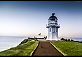
Cape Reinga Lighthouse

Last updated

Cape Reinga Lighthouse
NZ140415 Cape Reinga Lighthouse 01.jpg
Cape Reinga Lighthouse
Location North Island, Far North District, Northland Region, New Zealand OOjs UI icon edit-ltr-progressive.svg
Coordinates 34°25′36″S172°40′40″E / 34.426639°S 172.677639°E / -34.426639; 172.677639
Tower
Constructed1941  OOjs UI icon edit-ltr-progressive.svg
Constructionconcrete (tower)  OOjs UI icon edit-ltr-progressive.svg
Automated1987  OOjs UI icon edit-ltr-progressive.svg
Height10 m (33 ft)  OOjs UI icon edit-ltr-progressive.svg
Shapeoctagon  OOjs UI icon edit-ltr-progressive.svg
Markingswhite (tower), black (lantern)  OOjs UI icon edit-ltr-progressive.svg
Power sourcesolar power  OOjs UI icon edit-ltr-progressive.svg
Operator Maritime New Zealand   OOjs UI icon edit-ltr-progressive.svg
Light
First lit1941  OOjs UI icon edit-ltr-progressive.svg
Focal height165 m (541 ft)  OOjs UI icon edit-ltr-progressive.svg
Range19 nmi (35 km; 22 mi)  OOjs UI icon edit-ltr-progressive.svg
Characteristic Fl W 12s  OOjs UI icon edit-ltr-progressive.svg

Cape Reinga Lighthouse is a lighthouse at Cape Reinga in the Northland Region of the North Island of New Zealand. [1] [2] It is owned and operated by Maritime New Zealand. The lighthouse is a common New Zealand icon and a popular tourist destination although the lighthouse itself is not open to the public.

Contents

History

Journal kept by Cape Reinga Lighthouse Keeper (1945) Journal kept by Cape Reinga Lighthouse Keeper (11456459585).jpg
Journal kept by Cape Reinga Lighthouse Keeper (1945)

The lighthouse was built in 1941 and first lit during May of that year. It was the last manned light to be built in New Zealand and replaced the Cape Maria Van Diemen Lighthouse, located on nearby Motuopao Island, which had been built in 1879. Accessing that lighthouse was difficult due to the rough seas in the area, so in 1938, it was decided to move the lighthouse to Cape Reinga for safety reasons. The complete lantern fittings from Motuopao Island were reused at Cape Reinga, though the new lighthouse was fitted with a 1000 watt electrical lamp instead that could be seen for 26 nautical miles (48 km). The lamp was powered by a diesel generator.

In 1987, the lighthouse was fully automated and the lighthouse keepers were withdrawn. The lighthouse is now monitored remotely from Wellington. In May 2000 the original lens and lamp were replaced by a 50 watt beacon. The beacon is powered by batteries that are recharged by solar cells. The beacon flashes every 12 seconds and can be seen for 19 nautical miles (35 km).

See also

Related Research Articles

<span class="mw-page-title-main">Cape Reinga</span> Northwesternmost tip of New Zealand

Cape Reinga, and officially Cape Reinga / Te Rerenga Wairua, is the northwesternmost tip of the Aupouri Peninsula, at the northern end of the North Island of New Zealand. Cape Reinga is more than 100 km north of the nearest small town of Kaitaia. State Highway 1 extends all the way to the cape, but until 2010 was unsealed gravel road for the last 19 km. Suitable vehicles can also travel much of the way via Ninety Mile Beach and Kauaeparaoa Stream stream bed.

<span class="mw-page-title-main">Katiki Point Lighthouse</span> Lighthouse in New Zealand

The Katiki Point Lighthouse, also known as Moeraki Lighthouse, shone for the first time in 1878, following several accidents on the dangerous reefs around the area, to make the area safer for ships that sailed past on their way to Port Chalmers, Dunedin. The lighthouse was built between the settlements of Moeraki and Katiki, on the tip of the Moeraki Peninsula, which is known as Katiki Point or Moeraki Point.

<span class="mw-page-title-main">Baring Head Lighthouse</span> Lighthouse in New Zealand

Baring Head Lighthouse is a concrete lighthouse at Baring Head in the Wellington Region of the North Island of New Zealand, with an LED beacon powered by mains electricity. It is owned and operated by Maritime New Zealand, and can be accessed via walking tracks in the southern area of the East Harbour Regional Park, south of Wainuiomata.

<span class="mw-page-title-main">Cape Palliser Lighthouse</span> Lighthouse in New Zealand

Cape Palliser Lighthouse is a lighthouse at Cape Palliser in the Wellington region of the North Island of New Zealand. It is owned and operated by Maritime New Zealand.

<span class="mw-page-title-main">Nugget Point Lighthouse</span> Lighthouse in New Zealand

Nugget Point Lighthouse is a lighthouse at Nugget Point in the Otago region of the South Island of New Zealand. It is owned and operated by Maritime New Zealand.

<span class="mw-page-title-main">South Solitary Island Light</span> Lighthouse near Coffs Harbour in New South Wales, Australia

South Solitary Island Light is an active lighthouse on South Solitary Island, an island within the Solitary Islands Marine Park, about 15 kilometres (9.3 mi) northeast of Coffs Harbour, New South Wales, Australia. The lighthouse is located at the summit of the island. It is considered the most isolated lighthouse on the New South Wales coast. It was first in New South Wales to use kerosene over colza oil, and the last to do so before converting to electric power.

<span class="mw-page-title-main">Clarence River Light</span> Lighthouse in New South Wales, Australia

Clarence River Light, also known as Yamba Light or Clarence Head Light, is an active lighthouse located on Pilot Hill, a hill in Wooli Park, Yamba, New South Wales, Australia, south of the entrance of Clarence River. The current lighthouse was built in 1955, replacing a previous lighthouse built in 1880. It serves as the rear range light for two different ranges.

<span class="mw-page-title-main">Booby Island Light</span> Lighthouse

Booby Island Light is an active heritage-listed lighthouse located on Booby Island in the Shire of Torres, near the tip of Cape York Peninsula, west of Prince of Wales Island, within the Endeavour Strait, Queensland, Australia. It marks the western entrance to the navigation channel through the Torres Strait. It was the last of the major lights to be constructed along the Queensland coast.

The New Burnett Heads Light, also known as South Head Light, is an active lighthouse standing on the south side of the Burnett River entrance, in Burnett Heads, Queensland, Australia. In 1971 it replaced the Old Burnett Heads Light, which was relocated inland.

<span class="mw-page-title-main">Cape Capricorn Light</span> Lighthouse in Queensland, Australia

Cape Capricorn Light is an active heritage-listed lighthouse located on Cape Capricorn, a coastal headland on the northeast point of Curtis Island, in Gladstone Region, Central Queensland, Australia. The lighthouse, constructed in 1964, is the third at this site, following a timber frame lighthouse constructed in 1875 and a concrete lighthouse constructed around 1937. It was added to the Queensland Heritage Register on 31 August 2001.

<span class="mw-page-title-main">Cape Bowling Green Light</span> Lighthouse in Queensland, Australia

Cape Bowling Green Light is an active lighthouse located on Cape Bowling Green, a lengthy headland ending with a long low sandspit, about 30 kilometres (19 mi) from Ayr, Queensland, Australia. The lighthouse is at the end of the headland, near the base of the sandspit. The first lighthouse at the location, established in 1874, was moved multiple times. It was prefabricated in Brisbane, shipped to the location, moved twice due to coastal erosion and finally transferred for display at the Australian National Maritime Museum at Darling Harbour in Sydney.

<span class="mw-page-title-main">Cape Moreton Light</span> Lighthouse in Queensland, Australia

Cape Moreton Light, also listed as North Point Range Rear Light, is a heritage-listed active lighthouse located on Cape Moreton, a rocky headland located at the north eastern tip of Moreton Island, a large sand island on the eastern side of Moreton Bay, on the coast of South East Queensland, Australia. It marks the northern entrance to Moreton Bay and Brisbane and also serves as the rear light for the North Point Range. With its two distinctive red bands, it also serves as a daymark. It is the oldest lighthouse in Queensland, and the only one to be built by the New South Wales Government before the separation of Queensland, which took place in 1859. It is also the only lighthouse in Queensland to be built of stone.

<span class="mw-page-title-main">Cape Cleveland Light</span> Lighthouse in Queensland, Australia

Cape Cleveland Light is an active heritage-listed lighthouse located on the northern tip of Cape Cleveland, a promontory projecting into the Coral Sea west of Cleveland Bay in the locality of Cape Cleveland about 40 kilometres (25 mi) east of Townsville, Queensland, Australia. The lighthouse marks the northern point of the Cape, and the entrance to Cleveland Bay.

<span class="mw-page-title-main">Dent Island Light</span> Lighthouse

Dent Island Light is an active lighthouse on Dent Island, a small island off the coast of Queensland, Australia, part of the Whitsunday Group of the Whitsunday Islands. Located on the southwest tip of the island, the light guides ships navigating the Whitsunday Passage, between Whitsunday Island and the islands to the west, and marks the Dent Island Passage.

<span class="mw-page-title-main">Double Island Point Light</span> Lighthouse

Double Island Point Light is an active lighthouse located at the summit of Double Island Point, a coastal headland within the Cooloola section of the Great Sandy National Park. It is located at the southern end of Wide Bay, 70 kilometres (43 mi) north of Noosa Heads, Queensland, Australia.

<span class="mw-page-title-main">Pine Islet Light</span> Lighthouse

Pine Islet Light, also known as Percy Isles Light, is an active lighthouse located at Pine Islet, a small islet belonging to the Percy Isles group of the Northumberland Islands, about 130 kilometres (81 mi) southeast of Mackay, Queensland, Australia. The original lighthouse, established 1885, was active for a hundred years, until it was deactivated in 1985, by then the last kerosene powered lighthouse in Australia. It was relocated to the Mackay Marina in 1985 and restored to full working condition, making it the last fully functional kerosene operated lighthouse in the world. At the original location now stands a modern fiberglass tower.

<span class="mw-page-title-main">Eborac Island Light</span> Lighthouse

Eborac Island Light is an active lighthouse on Eborac Island, a small rocky island in the Adolphus Channel just off Cape York, the northern tip of Cape York Peninsula, Far North Queensland, Australia. It guides ships into the coastal channel inside the Great Barrier Reef. A concrete structure was built in 1921 and converted to solar power in 1990. It was replaced with a fiberglass structure in 2012.

Wharton Reef Light is an inactive lighthouse which used to be located on Wharton Reef in Princess Charlotte Bay off the Cape York Peninsula, Queensland, Australia. When it was deactivated in 1990 it was donated to the Townsville Maritime Museum and it is now on display near the museum. It is the only survivor of a series of twenty automatic lighthouses installed in Queensland during the "Golden Age of Australian Lighthouses" from 1913 to the early 1920s.

<span class="mw-page-title-main">Cape Arkona Lighthouses</span> Lighthouse in Mecklenburg-Western Pomerania, Germany

The Cape Arkona Lighthouse comprises two lighthouses and a radio navigation tower on the German Baltic Sea coast in Mecklenburg-Vorpommern, with the international serial number C 1062. It is located on Cape Arkona on the peninsula of Wittow on the northern tip of the island of Rügen.

<span class="mw-page-title-main">Farewell Spit Lighthouse</span> Lighthouse in New Zealand

Anchored firmly at the end of New Zealand's longest sand spit, the Farewell Spit Lighthouse guides vessels entering Cook Strait from the west and south. The LED rotating beacon flashes white or red, once every 15 seconds. It has a range of 19 nautical miles. Red is shown to warn approaching vessels of extensive shoaling. Standing 27 metres (89 ft) tall, the tower raises higher than most lighthouses, because the shifting sands it is built on are almost at sea level. It is constructed of an open steel lattice to withstand abrasive sand and salt-laden winds.

References

  1. Rowlett, Russ. "Lighthouses of New Zealand: North Island". The Lighthouse Directory. University of North Carolina at Chapel Hill . Retrieved 13 November 2015.
  2. Cape Reinga Lighthouse Profile Archived 11 July 2015 at the Wayback Machine (from the Maritime New Zealand website)