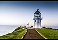
Baring Head Lighthouse

Last updated

Baring Head Lighthouse
Baring Head lighthouse.jpg
Baring Head Lighthouse
LocationBaring Head, North Island
New Zealand
Coordinates 41°24′29″S174°52′16″E / 41.40806°S 174.87111°E / -41.40806; 174.87111
Tower
Constructed1935
Constructionconcrete tower
Automated1989
Height12.2 metres (40 ft)
Shapeoctagonal tower with balcony and lantern
Markingswhite tower and lantern, greenish lantern dome
Power sourcesolar power  OOjs UI icon edit-ltr-progressive.svg
OperatorMaritime New Zealand [1]
Light
First litJune 1935
Focal height87 metres (285 ft)
Range10 nautical miles (19 km; 12 mi)
Characteristic Oc W 15s

Baring Head Lighthouse is a concrete lighthouse at Baring Head in the Wellington Region of the North Island of New Zealand, with an LED beacon powered by mains electricity. [2] It is owned and operated by Maritime New Zealand, and can be accessed via walking tracks in the southern area of the East Harbour Regional Park, south of Wainuiomata.

Contents

The lighthouse tower is 12.2 m tall (40 ft), but the hilltop elevation gives a focal height of 87 m (285 ft). [2] The light range is 10 nautical miles (19 km; 12 mi).

The lighthouse was built to be the main approach light to Wellington Harbour, as well as a coastal light for Cook Strait. Lit on 18 June 1935, it replaced the light at Pencarrow Head, which was decommissioned later that year. [2] The lighthouse was initially powered by a diesel generator but was converted to mains electricity in 1950. [3] The 1000 W light was fully automated in 1989 and demanned. In February 2005, the original lens was replaced by a flashing LED beacon visible from up to 18 kilometres (10 nmi; 11 mi). [3]

See also

Related Research Articles

<span class="mw-page-title-main">The Brothers (New Zealand)</span>

The Brothers is a group of small islands in Cook Strait, New Zealand, off the east coast of Cape Koamaru, Arapaoa Island. The islands are a restricted-access wildlife sanctuary administered by the Department of Conservation.

<span class="mw-page-title-main">Macquarie Lighthouse</span> Lighthouse in New South Wales, Australia

The Macquarie Lighthouse, also known as South Head Upper Light, is the first, and is the longest serving, lighthouse site in Australia. It is located on Dunbar Head, on Old South Head Road, Vaucluse in the Municipality of Woollahra local government area of New South Wales, Australia. The lighthouse is situated approximately 2 kilometres (1 mi) south of South Head near the entrance to Sydney Harbour. There has been a navigational aid in this vicinity since 1791 and a lighthouse near the present site since 1818. The current heritage-listed lighthouse was completed in 1883. The lighthouse and associated buildings were designed by James Barnet and built from 1881 to 1883.

<span class="mw-page-title-main">Cape Reinga Lighthouse</span> Lighthouse in New Zealand

Cape Reinga Lighthouse is a lighthouse at Cape Reinga in the Northland Region of the North Island of New Zealand. It is owned and operated by Maritime New Zealand. The lighthouse is a common New Zealand icon and a popular tourist destination although the lighthouse itself is not open to the public.

<span class="mw-page-title-main">Kātiki Point Lighthouse</span> Lighthouse in New Zealand

The Kātiki Point Lighthouse, also known as Moeraki Lighthouse, shone for the first time in 1878, following several accidents on the dangerous reefs around the area, to make the area safer for ships that sailed past on their way to Port Chalmers, Dunedin. The lighthouse was built between the settlements of Moeraki and Kātiki, on the tip of the Moeraki Peninsula, which is known as Kātiki Point or Moeraki Point.

<span class="mw-page-title-main">Cape Palliser Lighthouse</span> Lighthouse in New Zealand

Cape Palliser Lighthouse is a lighthouse at Cape Palliser in the Wellington region of the North Island of New Zealand. It is owned and operated by Maritime New Zealand.

<span class="mw-page-title-main">Castle Point Lighthouse</span> Lighthouse in New Zealand

Castle Point Lighthouse, located near the village of Castlepoint in the Wellington Region of the North Island of New Zealand, is the North Island's tallest lighthouse standing 52 metres above sea level and is one of only two left in New Zealand with a rotating beam. It is owned and operated by Maritime New Zealand.

<span class="mw-page-title-main">Nugget Point Lighthouse</span> Lighthouse in New Zealand

Nugget Point Lighthouse is a lighthouse at Nugget Point in the Otago region of the South Island of New Zealand. It is owned and operated by Maritime New Zealand.

<span class="mw-page-title-main">Cape Campbell Lighthouse</span> Lighthouse in New Zealand

Cape Campbell Lighthouse is a lighthouse at Cape Campbell in the Marlborough region of the South Island of New Zealand. It is owned and operated by Maritime New Zealand. The original lighthouse at this site was first lit on 1 August 1870. However, this lighthouse was constructed of timber, and in 1898 these timbers were found to be decaying. This led to the construction of the current cast iron tower, which began operating in October 1905.

<span class="mw-page-title-main">Baring Head</span> Headland on North Island, New Zealand

Baring Head is a headland, located between Wellington Harbour and Palliser Bay at the southern end of the North Island of New Zealand. It marks the southern end of Fitzroy Bay.

<span class="mw-page-title-main">Rangitoto Lighthouse</span> Lighthouse in New Zealand

Rangitoto Lighthouse is a lighthouse off the coast in McKenzie Bay, in Auckland's Hauraki Gulf.

<span class="mw-page-title-main">Kiama Light</span> Lighthouse in New South Wales, Australia

Kiama Light, also known as Kiama Harbour Light, is an active lighthouse in Kiama, New South Wales, Australia. The lighthouse is located close to the Kiama Blowhole on Blowhole Point, south of Kiama Harbour.

<span class="mw-page-title-main">Nobbys Head Light</span> Lighthouse in New South Wales, Australia

Nobbys Head Light is an active lighthouse on Nobbys Head, a headland on the south side of the entrance to Newcastle Harbour, New South Wales, Australia. An image of the lighthouse is included in the coat of arms of the City of Newcastle.

<span class="mw-page-title-main">South Solitary Island Light</span> Lighthouse near Coffs Harbour in New South Wales, Australia

South Solitary Island Light is an active lighthouse on South Solitary Island, an island within the Solitary Islands Marine Park, about 15 kilometres (9.3 mi) northeast of Coffs Harbour, New South Wales, Australia. The lighthouse is located at the summit of the island. It is considered the most isolated lighthouse on the New South Wales coast. It was first in New South Wales to use kerosene over colza oil, and the last to do so before converting to electric power.

<span class="mw-page-title-main">Warden Head Light</span> Lighthouse in New South Wales, Australia

Warden Head Light, also known as Ulladulla Lighthouse, is an active lighthouse on Warden Head, a headland south of Ulladulla, New South Wales, Australia, guarding the entrance to the Port of Ulladulla. It is one of only two wrought iron lighthouses in New South Wales, the other being its sibling, Wollongong Breakwater Lighthouse. It is also notable for two relocations: the tower was constructed in 1873 on the Ulladulla Breakwater, and relocated in 1889 to its current location. Its keeper's house was relocated to a different location in the 1920s.

<span class="mw-page-title-main">Clarence River Light</span> Lighthouse in New South Wales, Australia

Clarence River Light, also known as Yamba Light or Clarence Head Light, is an active lighthouse located on Pilot Hill, a hill in Wooli Park, Yamba, New South Wales, Australia, south of the entrance of Clarence River. The current lighthouse was built in 1955, replacing a previous lighthouse built in 1880. It serves as the rear range light for two different ranges.

<span class="mw-page-title-main">Point Danger Light</span> Lighthouse in New South Wales, Australia

Point Danger Light, also known as the Captain Cook Memorial Light, is an active lighthouse located on Point Danger, a headland between Coolangatta and Tweed Heads, marking the border between Queensland and New South Wales, Australia. It lays claim to be the first lighthouse in the world to experiment with laser as a light source.

<span class="mw-page-title-main">Dog Island Lighthouse</span> Lighthouse at Foveaux Strait, New Zealand

The Dog Island Lighthouse on Dog Island in Foveaux Strait is New Zealand's tallest lighthouse, and one of its oldest. It is notable for its masonry construction, and is a work example by an engineer who was prominent at the time. The lighthouse employed the first revolving beam in New Zealand, and the unique original light apparatus was in use for 60 years. Dog Island Lighthouse is one of the most distinct lighthouses in New Zealand, with only two others having stripes painted on them for better visibility at daytime. The lighthouse is registered by Heritage New Zealand as a Category I structure, and the adjacent lighthouse keepers cottage has a Category II registration. Originally operated by three lighthouse keepers, the structure has since 1989 been remote controlled from Maritime New Zealand's Wellington office, with Dog Island since having been uninhabited. Dog Island Lighthouse has twice featured on New Zealand stamps.

<span class="mw-page-title-main">Tuhawaiki Point Lighthouse</span> Lighthouse in New Zealand

The Tuhawaiki Point Lighthouse or Jack's Point Lighthouse stands near to Timaru at the east coast of the South Island of New Zealand.

<span class="mw-page-title-main">Mew Island Lighthouse</span> Lighthouse in Northern Ireland

Mew Island Lighthouse is an active lighthouse within the Copeland Islands of County Down in Northern Ireland. The current 19th-century tower is the most recent in a series of lighthouses that have been built in the islands, which have helped to guide shipping around the archipelago and into Belfast Lough.

<span class="mw-page-title-main">Farewell Spit Lighthouse</span> Lighthouse in New Zealand

The Farewell Spit Lighthouse is located at the end of New Zealand's longest sand spit in Golden Bay / Mohua, near the northern tip of the South Island. It guides vessels entering Cook Strait from the west and south. The LED rotating beacon flashes white or red, once every 15 seconds. It has a range of 19 nautical miles. Red is shown to warn approaching vessels of extensive shoaling. Standing 27 metres (89 ft) tall, the tower needs to be taller than the support structures of most lighthouses built on cliffs or headlands, because the sand foundations it is built upon are almost at sea level. The tower is constructed of an open steel lattice to withstand abrasive sand and salt-laden winds.

References

  1. Rowlett, Russ. "Lighthouses of New Zealand: North Island". The Lighthouse Directory. University of North Carolina at Chapel Hill . Retrieved 22 February 2016.
  2. 1 2 3 "Baring Head Lighthouse". Maritime New Zealand website. Archived from the original on 26 January 2020. Retrieved 5 January 2017.
  3. 1 2 "Baring Head Lighthouse". (section "Operation of the Baring Head Light"). Archived from the original on 26 January 2020. Retrieved 5 January 2017.