Akaroa is a small town on Banks Peninsula in the Canterbury Region of the South Island of New Zealand, situated within a harbour of the same name. The name Akaroa is Kāi Tahu Māori for "Long Harbour", which would be spelled Whangaroa in standard Māori. The area was also named Port Louis-Philippe by French settlers after the reigning French king Louis Philippe I.

Cape Spear is a headland located on the Avalon Peninsula of Newfoundland near St. John's in the Canadian province of Newfoundland and Labrador. At a longitude of 52°37' W, it is the easternmost point in Canada and North America, excluding Greenland.

The National Trust for Canada is a national registered charity in Canada with the mandate to inspire and lead action to save historic places, and promote the care and wise use of our historic environment.

Heritage New Zealand Pouhere Taonga is a Crown entity with a membership of around 20,000 people that advocates for the protection of ancestral sites and heritage buildings in New Zealand. It was set up through the Historic Places Act 1954 with a mission to "...promote the identification, protection, preservation and conservation of the historical and cultural heritage of New Zealand" and is an autonomous Crown entity. Its current enabling legislation is the Heritage New Zealand Pouhere Taonga Act 2014.

Tiritiri Matangi Lighthouse, also known as Tiritiri Lighthouse, is a lighthouse on Tiritiri Matangi, an island in the Hauraki Gulf 28 km north of Auckland in the North Island of New Zealand. It is owned and operated by Maritime New Zealand. It is considered the best-preserved lighthouse complex in the country, and is the oldest lighthouse in New Zealand still in operation. It was once the most powerful lighthouse in the Southern Hemisphere.

Pencarrow Head Lighthouse is a decommissioned lighthouse at Pencarrow Head in the Wellington region of the North Island of New Zealand.

The Boulder Bank is a very unusual naturally formed landform in Nelson, New Zealand. It is a 13 kilometre long stretch of rocky substrate which begins at the Mackay Bluff and ends at the Cut of the Nelson Harbour. Haulashore Island was once a part of the Boulder Bank, but the Cut made it an island, and it is no longer connected to the Boulder Bank. The Boulder Bank separates Tasman Bay and the Nelson Haven and is managed as a scenic reserve by the Department of Conservation. Land access is gained along Boulder Bank Drive, signposted at the northern end of Nelson Haven on State Highway 6.

Shag Point / Matakaea is a headland and township in East Otago, New Zealand. Both the point and the nearby Shag River take their English name from a seabird, the pied shag.

The Ministry for Culture and Heritage is the department of the New Zealand Government responsible for supporting the arts, culture, built heritage, sport and recreation, and broadcasting sectors in New Zealand and advising government on such.

Point Clark Lighthouse is located on in a beach community, Point Clark, Ontario, near a point that protrudes into Lake Huron. Built between 1855 and 1859 under the instructions of the Board of Works, Canada West, it is one of the few on the Great Lakes to be made primarily from stone. It is one of the Imperial Towers, a group of six nearly identical towers built by contractor John Brown for the "Province of Canada" on Lake Huron and Georgian Bay, all completed by 1859. The location for the Point Clark lighthouse was selected to warn sailors of the shoals (sandbars) 2 miles (3.2 km) off the Lake Huron coast. It is still functioning as an automated light. A restoration that eventually exceeded $2.3 million started in 2011 and the facility reopened for tourism in June 2015.

Cape Brett Lighthouse is a lighthouse at Cape Brett in the Northland Region of the North Island of New Zealand. The site was surveyed and chosen in 1908 by Captain John Bollons of NZGSS Hinemoa.

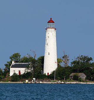
East Charity Shoal Light is an offshore lighthouse located near the Saint Lawrence River's entrance in northeastern Lake Ontario, due south of the city of Kingston, Ontario and approximately five miles (8 km) southwest of Wolfe Island. It is on the southeast rim of a 3,300-foot-diameter (1,000 m) submerged circular depression known as Charity Shoal Crater that may be the remnants of a meteorite impact.

Ogdensburg Harbor Light is a privately owned lighthouse on the St. Lawrence River, listed on the National Park Service's Maritime Heritage Program as Lighthouse to visit. and as one of New York's Historic Light Stations. In 2016 it was listed on the National Register of Historic Places.

Old Orchard Shoal Light was a sparkplug lighthouse in lower New York Bay marking a large shoal area. It was destroyed by Hurricane Sandy on October 29, 2012.

Low Point Lighthouse is an historic Canadian lighthouse marking the eastern entrance to Sydney Harbour at New Victoria, Nova Scotia, near New Waterford, Nova Scotia. This is one of the earliest and most important light stations of Nova Scotia, one of the first dozen beacons in Nova Scotia to be lit to guide mariners, a classic red-and-white lighthouse still operated by the Canadian Coast Guard.
Waipiro Bay is a small coastal settlement in the Gisborne District on the East Coast of the North Island of New Zealand. The name also refers to the bay that the settlement is built on. It was named Waipiro by Chief Paoa, which translates literally to "putrid water", referring to the area's sulphuric properties. It is in the Waiapu ward, along with nearby towns Te Puia Springs, Tokomaru Bay, and Ruatoria. It is located 15 km (9 mi) south of Ruatoria, 77 km (48 mi) north-east of Gisborne, and 41 km (25 mi) south-west of the East Cape Lighthouse, the easternmost point of mainland New Zealand. By road, it is 103 km (64 mi) from Gisborne, and 231 km (144 mi) from Ōpōtiki. Waipiro Bay is governed by the Gisborne District Council, and is in the East Coast electorate.

The Dog Island Lighthouse on Dog Island in Foveaux Strait is New Zealand's tallest lighthouse, and one of its oldest. It is notable for its masonry construction, and is a work example by an engineer who was prominent at the time. The lighthouse employed the first revolving beam in New Zealand, and the unique original light apparatus was in use for 60 years. Dog Island Lighthouse is one of the most distinct lighthouses in New Zealand, with only two others having stripes painted on them for better visibility at daytime. The lighthouse is registered by Heritage New Zealand as a Category I structure, and the adjacent lighthouse keepers cottage has a Category II registration. Originally operated by three lighthouse keepers, the structure has since 1989 been remote controlled from Maritime New Zealand's Wellington office, with Dog Island since having been uninhabited. Dog Island Lighthouse has twice featured on New Zealand stamps.
The Chantry Island Lighthouse, officially known as Chantry Island Lightstation Tower, is a lightstation on Chantry Island, off the coast of Southampton, Ontario in Lake Huron. It was constructed in the years 1855 through to 1859, by John Brown of Thorold, Ontario, under the authority of the Province of Canada and is recognized as one of the six Imperial Towers. Virtually identical, they were completed in 1858-1859 on Lake Huron and Georgian Bay and are among the few lighthouses on the Great Lakes made of cut limestone and granite.

Boulder Bank Lighthouse is a decommissioned 19th century lighthouse located near the Port Nelson end of the Boulder Bank. It was New Zealand's second permanent lighthouse.

Bean Rock Lighthouse is a lighthouse situated at the end of a reef in the Waitematā Harbour in Auckland, New Zealand. It is the only remaining example in New Zealand of a wooden cottage-style lighthouse, and it is one of only a few remaining worldwide. It is also the oldest wooden lighthouse and only wave-washed tower in New Zealand. It is owned, operated and maintained by Ports of Auckland.