
Wellington is the capital city of New Zealand. It is located at the south-western tip of the North Island, between Cook Strait and the Remutaka Range. Wellington is the major population centre of the southern North Island, and is the administrative centre of the Wellington Region, which also includes the cities of Porirua, Upper Hutt and Lower Hutt, the Kapiti Coast and the Wairarapa. It is the world's southernmost capital of a sovereign state. Wellington features a temperate maritime climate, and is the world's windiest city by average wind speed.

Greater Wellington, also known as the Wellington Region, is a non-unitary region of New Zealand that occupies the southernmost part of the North Island. The region covers an area of 8,049 square kilometres (3,108 sq mi), and has a population of 547,000.
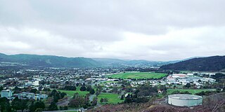
Upper Hutt is a city in the Wellington Region of New Zealand and one of the four cities that constitute the Wellington metropolitan area.

Te Awa Kairangi / Hutt River flows through the southern North Island of New Zealand. It flows south-west from the southern Tararua Range for 56 kilometres (35 mi), forming a number of fertile floodplains, including Kaitoke, central Upper Hutt and Lower Hutt.
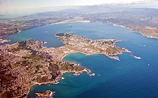
Wellington Harbour is a large natural harbour on the southern tip of New Zealand's North Island. New Zealand's capital city, Wellington, is located on parts of its western and southern sides. Lower Hutt is located on parts of its northern and western sides.
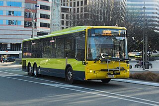
The Wellington Region has a well developed public transport system, the most used in New Zealand. It consists of electric and diesel buses, commuter trains, ferries and a funicular. It also included trams until 1964 and trolleybuses until 2017.

Regional parks of New Zealand are protected areas administered by regional councils, the top tier of local government.

Te Āti Awa is a Māori iwi with traditional bases in the Taranaki and Wellington regions of New Zealand. Approximately 17,000 people registered their affiliation to Te Āti Awa in 2001, with around 10,000 in Taranaki, 2,000 in Wellington and around 5,000 of unspecified regional location.
Wellington Rugby League is the local sporting body responsible for the administration of Rugby league in the Greater Wellington region. It is responsible for the local competition of the same name, as well as its representative team, the Wellington rugby league team.

Manor Park railway station is a suburban railway station serving the suburb of Manor Park in Lower Hutt, New Zealand. The station is located on the Hutt Valley section of the Wairarapa Line, 23.7 km (14.7 mi) northeast of Wellington. The station is served by Metlink's electric multiple unit trains of the "Matangi" FP class. Trains stopping at Manor Park run to Wellington and Upper Hutt. The station has an island platform between two tracks.
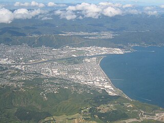
Lower Hutt is a city in the Wellington Region of New Zealand. Administered by the Hutt City Council, it is one of the four cities that constitute the Wellington metropolitan area.

Kaitoke Regional Park is regional park located at Kaitoke, northeast of Upper Hutt, in the Wellington Region of New Zealand's southern North Island. It is administered by Wellington Regional Council, alongside the adjacent regional park of Hutt Water Collection Area.
The Wellington local elections, 2010 are part of the 2010 New Zealand local elections, to elect members to sub-national councils and boards. The Wellington elections cover one regional council, eight territorial authority councils, three district health boards, and various local boards and licensing trusts.
The 2016 Wellington local elections were part of the wider 2016 New Zealand local elections, to elect members to sub-national councils and boards. The Wellington elections cover one regional council, eight territorial authority councils, three district health boards, and various local boards and licensing trusts.
Water supply and sanitation in the Wellington region involves the provision of the "three waters" – drinking water, stormwater, and wastewater services in the Greater Wellington region.
Water supply in the Wellington region involves the provision of drinking water services in the Greater Wellington region of New Zealand.

Hutt Water Collection Area is a regional park located in Upper Hutt in the Wellington Region at the southern end of New Zealand's North Island. It is administered by Wellington Regional Council and is located alongside the larger Kaitoke Regional Park.
Wainuiomata Regional Park is a regional park located near Wainuiomata, Lower Hutt in the Wellington Region at the southern end of New Zealand's North Island. It is administered by Wellington Regional Council. In January 2022 the park's name officially changed from Wainuiomata Recreation Area to Wainuiomata Regional Park.
Wainuiomata Water Collection Area is a regional park located near Wainuiomata, Lower Hutt in the Wellington Region at the southern end of New Zealand's North Island. It is administered by Wellington Regional Council, for exclusive use by Wellington Water as a water catchment reserve. The park covers the catchments of the Wainuiomata River and the Ōrongorongo River. It adjoins Remutaka Forest Park and Wainuiomata Recreation Area.
