Poor Knights Islands

Last updated

Poor Knights Islands
Tawhiti Rahi ( Māori )
Poor Knights Islands
Geography
Location Northland, New Zealand
Coordinates 35°30′S174°45′E / 35.500°S 174.750°E / -35.500; 174.750
Area2.714 [1]  km2 (1.048 sq mi)
Administration
New Zealand
Designated1975
Poor Knights lily (Xeronema callistemon) plants growing in situ Xeronema callistemon on Poor Knights Islands.JPG
Poor Knights lily ( Xeronema callistemon ) plants growing in situ
Flowering Poor Knights lily in cultivation Xeronema.jpg
Flowering Poor Knights lily in cultivation
Large numbers of Buller's shearwaters breed on the islands Bullershearwater.jpg
Large numbers of Buller's shearwaters breed on the islands
The waters off the Poor Knights are a marine reserve with subtropical species Two Clown Nudibranchs.JPG
The waters off the Poor Knights are a marine reserve with subtropical species

The Poor Knights Islands (Māori: Tawhiti Rahi) are a group of islands off the east coast of the Northland Region of the North Island of New Zealand. They lie 50 kilometres (31 mi) to the northeast of Whangārei, and 22 kilometres (14 mi) offshore halfway between Bream Head and Cape Brett. Uninhabited since the 1820s, they are a nature reserve and popular underwater diving spot, with boat tours typically departing from Tutukaka. The Poor Knights Islands Marine Reserve surrounds the island.

Contents

Beaglehole (1955) comments that the origin of the island name is not clear, and speculates that the name could be related to the Poor Knights of Windsor, or that the islands were named for their resemblance to Poor Knight's Pudding, a bread-based dish topped with egg and fried, popular at the time of discovery by Europeans.

Description

The chain consists of two large islands (Tawhiti Rahi, the larger at 151.5 ha (374 acres), and Aorangi (101 ha (250 acres)) to the south), [2] and several smaller islands. Aorangaia and Archway Island lie to the southwest of Aorangi Island, and there is also a group of smaller rocky islets between the two main islands, the largest of which is Motu Kapiti Island. Others include Bird and Kaka Rock. To the south, there is a smaller island named Ngoio Rock. The Poor Knights Islands are the eroded remnants of a 4-million-year-old rhyolitic volcano that is estimated to have been 1,000 metres (3,300 ft) tall and 25 kilometres (16 mi) in diameter. [3]

Oceanography

Spring tide range for the islands is around 2 m (6.56 ft), decreasing to a neap tide of around 1 m (3.28 ft). The deep water around the island results in only moderate tidal currents. These are around the same magnitude as the prevailing shelf currents. In the general vicinity of the islands mean flows are around 0.2 m/s (0.656 ft/s) and run toward the southeast. [4]

A remarkable feature of the region is the large internal tides that occur. These are a form of internal wave driven by the local tidal flow forcing the stratification against sloping areas of the shelf face. The surface manifestation of these waves can be seen from space. [5] These waves generate brief highly localised accelerations. Internal wave amplitudes of around 100 m (109 yd) have been observed, generating flow speeds as great as 0.5 m/s (1.64 ft/s). [6]

Geology

The Poor Knights Islands were created in some of the earliest eruptions of the Coromandel Volcanic Zone, between 10 and 9.5 million years ago. The Poor Knights Islands vulcanism represents an early period for the Coromandel Volcanic Zone, as changes in tectonic forces caused the east belt of the Northland Arc (23 to 16 million years ago) to begin moving southwards, and eventually forming the modern Taupō Volcanic Zone. [7]

Environment

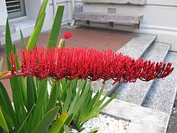
The islands are protected as a nature reserve and a permit is required to land or tie boats up. Permits are usually granted only for scientific research. A notable native plant of the islands is the spectacularly flowering Poor Knights lily, which has become a popular garden plant.

Feral pigs, which had roamed Aorangi since the departure of Māori in the 1820s, were exterminated in 1936. [8] The islands have been identified as an Important Bird Area, by BirdLife International because they are home to a breeding population of about 200,000 pairs of Buller's shearwaters. [9]

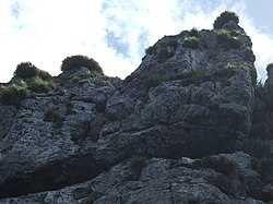
The islands contain rock arches and sea caves, including Rikoriko Cave, the largest cave in the world by volume, with a cavern measuring 221,494 cubic metres (7,822,000 cu ft) and an opening large enough for small tour boats to enter. [10] [11] Rikoriko Cave measures 130 by 80 metres (430 by 260 ft), with a ceiling height of 35 metres (115 ft) and extends 26 metres (85 ft) deep below water. [3]

Tawhiti Rahi contains the Northern Arch, Middle Arch, and Maomao Arch, the latter being a popular diving location. Aorangaia Island's east–west rock arch resembles a long tunnel, while the aptly named Archway Island is bisected by two rock arches, with the larger Cathedral Arch about 40 metres (130 ft) tall. [12]

History

The islands were earlier inhabited by Māori of the Ngāti Wai tribe who grew crops and fished the surrounding sea. The tribe traded with other Maori.

A chief of the tribe named Tatua led his warriors on a fighting expedition to the Hauraki Gulf with Ngā Puhi chief Hongi Hika in the early 1820s. While they were away, a slave named Paha escaped the islands and travelled to Hokianga where he told Waikato, a chief of the Hikutu tribe, that the islands had been left undefended. As Waikato had been offended by Tatua some years previous when he was refused pigs he had come to trade for, so he and his warriors set out on three large canoes to attack the islands. They arrived at the islands one night in December 1823 [13] and soon overpowered the islanders in the absence of their warriors. Many islanders jumped off the high cliffs to avoid being taken as slaves. Tatua's wife Oneho and daughter were captured and taken to the mainland where a distant relative recognised the wife and helped the two to escape.

Tatua returned to the islands to find a scene of destruction. Only nine or ten people were left on the islands, including his five-year-old son Wehiwehi who had been hidden in a cave during the attack. The islands were declared tapu and Tatua left with the survivors and went to Rawhiti in the Bay of Islands where he unexpectedly found his wife and daughter. [14] [15] [16] [17]

See also

Related Research Articles

<span class="mw-page-title-main">Tolaga Bay</span> Town in Gisborne District, New Zealand

Tolaga Bay is both a bay and small town on the East Coast of New Zealand's North Island located 45 kilometres northeast of Gisborne and 30 kilometres south of Tokomaru Bay.

<span class="mw-page-title-main">White Island (Otago)</span> Island in New Zealand

White Island is an island 2,500 metres (2,700 yd) off the coast of Otago, within the boundaries of the city of Dunedin, South Island, New Zealand. It is uninhabited, and is a well-known landmark visible from the city's two inner city beaches at St Clair and St Kilda. The island is 80 metres (87 yd) in length and 30 metres (33 yd) wide at its widest point, covering 1,600 square metres (17,000 sq ft) and rising to a height of approximately 15 metres (49 ft). A rocky reef, parts of which break the surface at low tide, extends for 100 metres (110 yd) from the western end of the island.

<span class="mw-page-title-main">Hen and Chicken Islands</span> Archipelago off the coast of New Zealand

The Hen and Chicken Islands lie to the east of the North Auckland Peninsula off the coast of northern New Zealand. They lie 12 kilometres (7.5 mi) east of Bream Head and 40 kilometres (25 mi) south-east of Whangārei with a total area of 8.44 km2 (3.26 sq mi).

<span class="mw-page-title-main">Poor Knights Islands Marine Reserve</span> Protected area off the coast of New Zealand

The Poor Knights Islands Marine Reserve is a protected area off the coast of the North Island of New Zealand. The reserve, established in 1981 and covering an area of 1,890 ha, is administered by the Department of Conservation. It surrounds the Poor Knights Islands and adjacent rock stacks Sugarloaf Rock and High Peak Rocks. It is one of the world's ten most popular sites for scuba diving. with dive trips regularly leaving from the town of Tutukaka.

<span class="mw-page-title-main">Aorangaia Island</span> Island in New Zealand

Aorangaia Island is an island in the Northland Region of New Zealand, part of the Poor Knights Islands. It has a highest point of 102 metres (335 ft) and is 21 kilometres (13 mi) from the New Zealand mainland.

<span class="mw-page-title-main">Buller's shearwater</span> Species of bird

Buller's shearwater is a Pacific species of seabird in the family Procellariidae; it is also known as the grey-backed shearwater or New Zealand shearwater. A member of the black-billed wedge-tailed Thyellodroma group, among the larger shearwaters of the genus Ardenna, it forms a superspecies with the wedge-tailed shearwater.

<span class="mw-page-title-main">Solander Islands</span> Three islets off the South Island of New Zealand

The Solander Islands / Hautere are three uninhabited volcanic islets toward the western end of the Foveaux Strait just beyond New Zealand's South Island. The Māori name Hautere translates into English as "flying wind". The islands lie 38 km (24 mi) south of Prices Point, near where Lake Hakapoua drains through Big River to the ocean due west of Te Waewae Bay, and 64 km (40 mi) northwest of the Putatara (Rugged) Point in the northwest of Stewart Island / Rakiura, or 56 km (35 mi) from Codfish Island / Whenua Hou. The islands measure 1.2 km2 (0.46 sq mi). Administratively, the islands form part of Southland District, making them the only uninhabited outlying island group of New Zealand to be part of a local authority.

<i>Nestegis apetala</i> Species of tree

Nestegis apetala is a small tree native to northern New Zealand and to Norfolk Island. The common names in New Zealand are coastal maire or broad-leaved maire. On Norfolk Island, the common name is ironwood. The species name apetala refers to the lack of petals on the flowers.

<span class="mw-page-title-main">French Pass</span> Narrow and treacherous stretch of water on the west of New Zealand

French Pass is a narrow and treacherous stretch of water that separates D'Urville Island, at the north end of the South Island of New Zealand, from the mainland coast. At one end is Tasman Bay, and at the other end the outer Pelorus Sound / Te Hoiere leads out to Cook Strait.

Hardy's skink is a species of skink, a lizard in the family Scincidae. The species is endemic to the Poor Knights Islands of New Zealand.

Izatha dulcior is a species of moth in the family Oecophoridae. It is endemic to New Zealand. This species is classified as "At Risk, Naturally Uncommon" by the Department of Conservation. I. dulcior is the first lepidoptera species described as endemic to the Poor Knights Islands.

<span class="mw-page-title-main">Te Tātua a Riukiuta</span> Scoria cone in Auckland, New Zealand

Te Tātua a Riukiuta / Big King is a volcano and Tūpuna Maunga in Three Kings, New Zealand that erupted 28,500 years ago. The volcano had three prominent peaks known as Three Kings and a number of smaller peaks until most of them were quarried away, leaving a sole remaining large peak known as Big King.

<i>Clitarchus rakauwhakanekeneke</i> Species of stick insect

Clitarchus rakauwhakanekeneke is a stick insect that belongs the common New Zealand genus Clitarchus. It lives only on the Poor Knights Islands.

<span class="mw-page-title-main">Tutukaka</span> Place in Northland Region, New Zealand

Tutukaka is a locality on the east coast of Northland, New Zealand, in an area commonly referred to as the Tutukaka Coast which includes Ngunguru and Matapouri. The city of Whangārei is to the southwest. The residential areas of Tutukaka fringe the hills surrounding Tutukaka Harbour, which has a history as a local fishing port and hosts Tutukaka's marina. The Māori name comes from the term tūtū kākā, which means a parrot (kākā) snaring tree (tūtū).

Hawea Marine Reserve is a marine reserve covering an area of 411 hectares in Hāwea / Bligh Sound, in Fiordland on New Zealand's South Island. It was established in 2005 and is administered by the Department of Conservation.

<span class="mw-page-title-main">Te Matuku Marine Reserve</span>

Te Matuku Marine Reserve is a marine reserve administered by the New Zealand Department of Conservation. It includes Te Matuku Bay, one of the largest and least disturbed estuaries on Waiheke Island, as well as a surrounding area of sea. It covers an area of 690 ha and was established in 2003.

<span class="mw-page-title-main">Tauparikākā Marine Reserve</span>

Tauparikākā Marine Reserve is a marine reserve located offshore about 20 kilometres (12 mi) north of Haast on the West Coast of New Zealand's South Island. It covers the area immediately offshore from Ship Creek, which is also known as Tauparikākā in Māori.

<span class="mw-page-title-main">Te Angiangi Marine Reserve</span>

Te Angiangi Marine Reserve is a marine reserve covering a marine area of 446 hectares in the Hawke's Bay Region of New Zealand's North Island. It was established in 1997 and is administered by the Department of Conservation.

Cylix tupareomanaia, the Manaia pygmy pipehorse, is a species of syngnathid, the family of seahorses and pipefish, and is endemic to New Zealand. It was first described in 2021, and is found in the northern parts of the North Island of New Zealand.

The Wharepapa / Arthur Range is a mountain range partially marking the boundary between the Tasman District and West Coast Region of New Zealand's South Island. The range is at the eastern extent of the Tasman Mountains which make up much of the island's northwest, making it easily visible from across the low-lying Waimea Plains further to the east. The range's location and its many uses make it a significant site for local Māori, including the iwi of Te Ātiawa and Ngāti Rārua. This includes the prominent peaks of Mount Arthur and Pukeone / Mount Campbell, which both hold mana in their own right and have become part of the identity of the aforementioned iwi.

References

  1. "Data Table – Protected Areas – LINZ Data Service (recorded area 271.4 ha, incl. Sugarloaf Rock and High Peak Rocks)". Land Information New Zealand . Retrieved 27 August 2019.
  2. West, Carol J. (1999). Poor Knights Islands weed control programme, Conservation Advisory Science Notes No. 233, Department of Conservation, Wellington.
  3. 1 2 "The World's Largest Sea Cave". Tourism New Zealand . Retrieved 19 July 2018.
  4. Sharples, J.; Greig, M. J. N. (1998). "Tidal currents, mean flows, and upwelling on the north-east shelf of New Zealand". N. Z. J. Mar. Freshwater Res. 32 (2): 215–231. doi:10.1080/00288330.1998.9516821. Archived from the original on 1 August 2009.
  5. Sharples; et al. (2001). "Internal tide dissipation, mixing, and vertical nitrate flux at the shelf edge on NE New Zealand". J. Geophys. Res. 106 (C7): 14069–14081. Bibcode:2001JGR...10614069S. doi: 10.1029/2000jc000604 .
  6. Stevens, C.L.; Abraham, E.R.; Moore, C.M.; Boyd, P.W.; Sharples, J. (2005). "Observations of Small-Scale Processes Associated with the Internal Tide Encountering an Island". J. Phys. Oceanogr. 35 (9): 1553–1567. Bibcode:2005JPO....35.1553S. CiteSeerX   10.1.1.569.1232 . doi:10.1175/JPO2754.1.
  7. Hayward, Bruce W. (2017). Out of the Ocean, Into the Fire. Geoscience Society of New Zealand. pp. 134–147. ISBN   978-0-473-39596-4.
  8. Cranwell, L.M.; Moore, L.B. (1938). "Intertidal Communities of the Poor Knights Islands, New Zealand". Transactions and Proceedings of the Royal Society of New Zealand. 67.
  9. BirdLife International. (2012). Important Bird Areas factsheet: Poor Knights Islands. Downloaded from http://www.birdlife.org on 4 February 2012.
  10. Bunnell, D. (May 2004). "Riko Riko Cave, New Zealand-World's Largest Sea Cave ?". NSS News. 62 (5): 145–147.
  11. "Poor Knights Island Marine Reserve" (PDF). Department of Conservation. p. 2. Retrieved 18 July 2018.
  12. Bruce W Hayward. "Geology and geomorphology of the Poor Knights Islands" (PDF). Auckland Institute and Museum. pp. 34–36. Retrieved 18 July 2018.
  13. Borley, Craig (27 May 2008). "'Maori Pompeii' yields treasures". The New Zealand Herald . Retrieved 3 November 2011.
  14. "Poor Knights Islands Marine Reserve Archived 27 September 2007 at the Wayback Machine ", Department of Conservation, New Zealand.
  15. The Poor Knights and The Poor Squires (The Pinnacles) Geology Archived 29 September 2007 at the Wayback Machine . Whangarei Deep Sea Anglers Club. Retrieved 31 May 2008.
  16. "Whakapapa", The Patuone Website.
  17. "Pre-European history – Dive! Tutukaka". diving.co.nz. Retrieved 16 July 2022.

35°30′S174°45′E / 35.500°S 174.750°E / -35.500; 174.750