Bay of Islands

Last updated

Bay of Islands
Urupukapuka Island.jpg
Urupukapuka Island
New Zealand (relief map).png
Disc Plain red.svg
Bay of Islands
Location North Island
Coordinates 35°12′S174°10′E / 35.200°S 174.167°E / -35.200; 174.167
Type Bay
Part of Pacific Ocean
Basin  countries New Zealand

The Bay of Islands is an area on the east coast of the Far North District of the North Island of New Zealand. It is one of the most popular fishing, sailing and tourist destinations in the country, and has been renowned internationally for its big-game fishing since American author Zane Grey publicised it in the 1930s. It is 60 km (37 mi) north-west of the city of Whangārei. Cape Reinga, at the northern tip of the country, is about 210 km (130 mi) by road further to the north-west.

Contents

Geography

The bay itself is an irregularly-shaped 16 km (10 mi)-wide, 260 km2 (100 sq mi) [1] drowned valley system [2] and a natural harbour. It contains 144 islands, [1] of which the largest is Urupukapuka, [3] and numerous peninsulas and inlets. The three largest inlets are Waikare Inlet in the south, and Kerikeri and Te Puna (Mangonui) inlets in the north-west. The Purerua Peninsula, north of Te Puna Inlet, separates the north-western part of the bay from the Pacific Ocean, and Cape Brett Peninsula extends 10 km (6 mi) into the ocean at the eastern end of the bay. The biggest town is Kerikeri, followed by Paihia. The small town of Russell is located at the end of a short peninsula that extends into the bay from the southeast.

History

Kerikeri Kerikeri River mouth.jpg
Kerikeri

About 700 years ago, the Mātaatua, one of the large Māori migration canoes which journeyed to New Zealand from Hawaiki, was sailed to the Bay of Islands (from the Bay of Plenty) by Puhi, a progenitor of the Ngāpuhi iwi (tribe) which today is the largest in the country. [4] Māori settled and multiplied throughout the bay and on several of its many islands to establish various tribes such as the Ngāti Miru at Kerikeri. Many notable Māori were born in the Bay of Islands, including Hōne Heke who several times cut down the flagpole at Kororāreka (Russell) to start the Flagstaff War.

Many of the Māori settlements later played important roles in the development of New Zealand, such as Okiato (the nation's first capital), Waitangi (where the Treaty of Waitangi would later be signed) and Kerikeri, (which was an important departure point for inland Māori going to sea, and later site of the first permanent mission station in the country). Some of the islands became notable as well, such as Motu Apo (Te Pahi Island) where 60 of chief Te Pahi's people were killed as revenge after he was wrongly accused of being responsible for the Boyd Massacre at Whangaroa.

The first European to visit the area was Captain Cook, who named the region in 1769. The Bay of Islands was the first area in New Zealand to be settled by Europeans. Whalers arrived towards the end of the 18th century, while the first missionaries settled in 1814. The first full-blooded European child recorded as being born in the country, Thomas King, was born in 1815 at Oihi Bay in the Bay of Islands (there have been unsubstantiated claims that a European girl was born earlier at the Dusky Sound settlement in the South Island).

The bay has many interesting historic towns including Paihia, Russell, Waitangi and Kerikeri. Russell, formerly known as Kororāreka, was the first permanent European settlement in New Zealand, and dates from the early 19th century. Kerikeri contains many historic sites from the earliest European colonial settlement in the country. These include the Mission House, also called Kemp House, which is the oldest wooden structure still standing in New Zealand. The Stone Store, a former storehouse, is the oldest stone building in New Zealand, construction having begun on 19 April 1832.

The Bay of Islands was visited in the 19th century by sealing ships and whaling ships that hunted in the ocean around New Zealand, [5] often bartering with local iwi to restock their food supplied with local potatoes and pork. [6] In December 1835 Charles Darwin visited the Bay of Islands in HMS Beagle. [7] [8] In February 1840, some members of the United States Exploring Expedition were present at the initial signing of the Treaty of Waitangi at Waitangi. [9]

In a 2006 study, the Bay of Islands was found to have the second bluest sky in the world, after Rio de Janeiro. [10]

A new fast boat manufactured by the Explore Group was introduced in the Bay of Islands in 2019 to take visitors to the Hole in the Rock at speed. The daily transport facility can seat up to 30 passengers and will ply several times during the day. [11]

Cream Trip

In 1886, Albert Ernest Fuller launched the sailing ship Undine in the Bay of Islands to deliver coal supplies to the islands within the Bay. With the fitting of a motor in the early 20th century, Fuller was able to deliver the coal and essential supplies to communities as far out as Cape Brett.

In 1927 Fuller acquired Cream Trip from Eddie Lane – with the facilities on board to transport cream from the islands, and by the 1960s, the newly commissioned Bay Belle started this run.

Although a modern catamaran now takes this historical route of the original Cream Trip, Bay Belle continues to transport visitors and locals between Paihia and Russell throughout the day. [12]

Related Research Articles

<span class="mw-page-title-main">Flagstaff War</span> 1845–46 conflict between the British Empire and Māori warriors in Northland, New Zealand

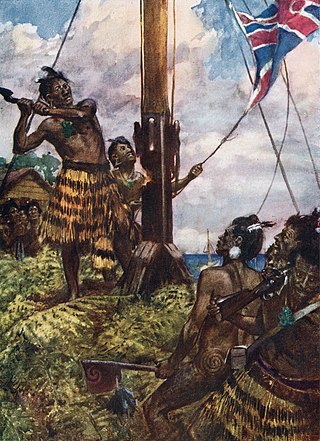
The Flagstaff War, also known as Heke's War, Hōne Heke's Rebellion and the Northern War, was fought between 11 March 1845 and 11 January 1846 in and around the Bay of Islands, New Zealand. The conflict is best remembered for the actions of Hōne Heke who challenged the authority of the British by cutting down the flagstaff on Flagstaff Hill at Kororāreka. The flagstaff had been a gift from Hōne Heke to James Busby, the first British Resident. The Northern War involved many major actions, including the Battle of Kororāreka on 11 March 1845, the Battle of Puketutu on 8 May 1845, the Battle of Ōhaeawai on 23 June 1845 and the siege of Ruapekapeka Pā from 27 December 1845 to 11 January 1846.

<span class="mw-page-title-main">Russell, New Zealand</span> Town in the Northland Region of New Zealand

Russell, also known by the Māori name Kororāreka, is a town in the Bay of Islands, in New Zealand's far north. It was the first permanent European settlement and seaport in New Zealand.

<span class="mw-page-title-main">Northland Region</span> Region of New Zealand

The Northland Region is the northernmost of New Zealand's 16 local government regions. New Zealanders sometimes refer to it as the Winterless North because of its mild climate all throughout the year. The main population centre is the city of Whangārei, and the largest town is Kerikeri. At the 2018 New Zealand census, Northland recorded a population growth spurt of 18.1% since the previous 2013 census, placing it as the fastest growing region in New Zealand, ahead of other strong growth regions such as the Bay of Plenty Region and Waikato.

<span class="mw-page-title-main">Waitangi, Northland</span> Locality in the Bay of Islands, North Island, New Zealand

Waitangi is a locality on the north side of the Waitangi River in the Bay of Islands, 60 kilometres north of Whangarei, on the North Island of New Zealand. It is close to the town of Paihia, to which it is connected by a bridge near the mouth of the Waitangi River estuary. While Statistics New Zealand and NZ Post consider the southern boundary of Waitangi to be the river and estuary, with the area further south being part of Paihia, the area by Te Tī Bay, immediately south of the river, is sometimes referred to as part of Waitangi.

<span class="mw-page-title-main">Ngāpuhi</span> Māori iwi in New Zealand

Ngāpuhi is a Māori iwi associated with the Northland regions of New Zealand centred in the Hokianga, the Bay of Islands, and Whangārei.

<span class="mw-page-title-main">Far North District</span> Territorial authority district in Northland Region, New Zealand

The Far North District is the northernmost territorial authority district of New Zealand, consisting of the northern part of the Northland Peninsula in the North Island. It stretches from North Cape / Otou and Cape Reinga / Te Rerenga Wairua in the north, down to the Bay of Islands, the Hokianga and the town of Kaikohe.

<span class="mw-page-title-main">Paihia</span> Town in Northland Region, New Zealand

Paihia is the main tourist town in the Bay of Islands in the Northland Region of the North Island of New Zealand. It is 60 kilometres north of Whangārei, located close to the historic towns of Russell and Kerikeri. Missionary Henry Williams named the mission station Marsden's Vale. Paihia eventually became the accepted name of the settlement.

<span class="mw-page-title-main">Okiato</span> Place in Northland Region, New Zealand

Okiato or Old Russell is a small town in the Bay of Islands, New Zealand, 7 kilometres (4.3 mi) south of present-day Russell. It was founded in 1840 and served as New Zealand's first national capital until 1841, when the seat of government was moved to Auckland. The car ferry across the Bay of Islands, which provides the main access to Russell, runs between Okiato and Opua.

<span class="mw-page-title-main">Flagstaff Hill (New Zealand)</span>

Flagstaff Hill overlooks the Bay of Islands, New Zealand. Directly north of the small historical village of Russell, the flagstaff on the hill played a significant role in early relations between the local Māori of the Ngāpuhi iwi and early British colonials.

<span class="mw-page-title-main">Purerua Peninsula</span> Peninsula on the northwest side of the Bay of Islands in Northland, New Zealand

Purerua Peninsula is a peninsula on the northwest side of the Bay of Islands in Northland, New Zealand. Te Puna Inlet lies to the south of the peninsula. Communities on the peninsula are Purerua, Te Tii and Taronui Bay. Rangihoua Bay is at the southern end of the peninsula.

Gilbert Mair was a sailor and a merchant trader who visited New Zealand for the first time when he was twenty, and lived there from 1824 till his death. He married Elizabeth Gilbert Puckey – who had the first piano brought to New Zealand in 1827. They had twelve children. Among them were "famous New Zealanders" like Captain Gilbert Mair and Major William Gilbert Mair. Mair is a direct-line ancestor of Māori politician and activist Ken Mair.

<span class="mw-page-title-main">Rangihoua Bay</span> Bay on the Purerua Peninsula in Northland, New Zealand

Rangihoua Bay is a bay at the southern end of the Purerua Peninsula, on the north-west shore of the Bay of Islands in Northland, New Zealand. It is 10 km north across the Bay of Islands from Russell and 12 km north from Paihia. By road it is 32 km from Kerikeri.

<span class="mw-page-title-main">Salt Air</span> Airline of New Zealand

Salt Air is a New Zealand charter airline based at Paihia in the Bay of Islands, in the Northland Region of the North Island.

<span class="mw-page-title-main">Capital of New Zealand</span>

Wellington has been the capital of New Zealand since 1865. New Zealand's first capital city was Old Russell (Okiato) in 1840–41. Auckland was the second capital from 1841 until 1865, when Parliament was permanently moved to Wellington after an argument that persisted for a decade. As the members of parliament could not agree on the location of a more central capital, Wellington was decided on by three Australian commissioners.

<span class="mw-page-title-main">Edward Marsh Williams</span>

Edward Marsh Williams was a missionary, interpreter, and judge who played a significant role in the British colonisation of New Zealand. He was born in Hampstead, Middlesex, the eldest son of Archdeacon Henry Williams and Marianne Williams.

The New Zealand Church Missionary Society (NZCMS) is a mission society working within the Anglican Communion and Protestant, Evangelical Anglicanism. The parent organisation was founded in England in 1799. The Church Missionary Society (CMS) sent missionaries to settle in New Zealand. The Rev. Samuel Marsden, the Society's Agent and the Senior Chaplain to the New South Wales government, officiated at its first service on Christmas Day in 1814, at Oihi Bay in the Bay of Islands, New Zealand.

<span class="mw-page-title-main">Christ Church, Russell</span> Church in New Zealand

Christ Church is New Zealand's oldest surviving church, located in the village of Russell.

<span class="mw-page-title-main">Pōmare II (Ngāpuhi)</span> Maori leader (d. 1850)

Pōmare II, originally named Whiria, was a Māori rangatira (chief) of the Ngāpuhi iwi (tribe) in New Zealand and the leader of the Ngāti Manu hapu (subtribe) of the Ngāpuhi. He was the nephew of Pōmare I, his mother Haki being the elder sister of Pōmare I. When he succeeded his uncle as leader of the Ngāti Manu he took his uncle's names, Whētoi and Pōmare. He is referred to as Pōmare II, so as to distinguish him from his uncle.
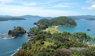
James Shepherd (1796–1882) was an Australian-born Wesleyan Christian missionary and settler in Northland, New Zealand. He was prominent in the early European community of the Bay of Islands, involved in construction of the Stone Store in Kerikeri, and involved in drafting of the first written Maori publications.

Puketona is a locality at the junction of State Highway 10 and State Highway 11 in the Far North District of New Zealand. Kerikeri is 10 kilometres north, Paihia is 14 kilometres east, Moerewa is 15 kilometres southeast, and Kaikohe is 20 kilometres southwest.

References

  1. 1 2 Hartel, Elizabeth F.; Constantine, Rochelle; Torres, Leigh G. (2014). "Changes in habitat use patterns by bottlenose dolphins over a 10-year period render static management boundaries ineffective". Aquatic Conservation: Marine and Freshwater Ecosystems. 25 (5): 701–711. doi:10.1002/aqc.2465.
  2. Edbrooke, S.W.; Brook, F.J. (compilers) (2009). Geology of the Whangarei Area. Institute of Geological & Nuclear Sciences 1:250 000 Geological Map 2 Archived 30 October 2014 at the Wayback Machine . Lower Hutt, New Zealand: GNS Science.
  3. "Historic Urupukapuka Island". Department of Conservation. Archived from the original on 25 October 2014. Retrieved 26 October 2014.
  4. "2006 Census – QuickStats About Māori (revised)". Statistics New Zealand. 4 April 2007. Archived from the original on 28 September 2007. Retrieved 25 May 2007.
  5. Wolfe, Richard (2005). Hellhole of the Pacific. Penguin Books(NZ). ISBN   0143019872.
  6. Colenso, William (1880). "On the vegetable food of the ancient New Zealanders before Cook's visit". Transactions and Proceedings of the Royal Society of New Zealand. 13: 3–38. Archived from the original on 24 June 2021. Retrieved 18 June 2021.
  7. Charles Darwin, Journal of a Voyage Round the World, 1831–36
  8. Fitzgerald, Caroline (2004). Marianne Williams: Letters from the Bay of Islands. Penguin Books, New Zealand. pp. 219–230. ISBN   0-14-301929-5.
  9. Wilkes, Charles (1845). Narrative of the United States exploring expedition during the years 1838, 1839, 1840, 1841, 1842. Vol. 2. Lea and Blanchard. p. 375. Archived from the original on 12 May 2021. Retrieved 22 April 2018. ...a disastrous circumstance for the natives...
  10. Dumé, Belle (2 August 2006). "World's bluest sky revealed". Optics.org. Archived from the original on 5 February 2019. Retrieved 16 July 2012.
  11. "New fast boat for Bay of Islands". The New Zealand Herald . 4 March 2019. Archived from the original on 4 May 2019. Retrieved 4 June 2019.
  12. "The Cream Trip". Fullers GreatSights Bay of Islands. Archived from the original on 3 March 2014. Retrieved 8 May 2014.