
Dhilba Guuranda–Innes National Park, formerly Innes National Park, is an IUCN-designated protected area in the Australian state of South Australia located on the southwest tip of Yorke Peninsula about 300 kilometres (190 mi) west of the state capital of Adelaide. It is a popular destination for camping, bushwalking, fishing, surfing and scuba diving.

The Bay of Islands is an area on the east coast of the Far North District of the North Island of New Zealand. It is one of the most popular fishing, sailing and tourist destinations in the country, and has been renowned internationally for its big-game fishing since American author Zane Grey publicised it in the 1930s. It is 60 km (37 mi) north-west of the city of Whangārei. Cape Reinga, at the northern tip of the country, is about 210 km (130 mi) by road further to the north-west.

Marc-Joseph Marion du Fresne was a French privateer, East India captain and explorer. The expedition he led to find the hypothetical Terra Australis in 1771 made important geographic discoveries in the south Indian Ocean and anthropological discoveries in Tasmania and New Zealand. In New Zealand they spent longer living on shore than any previous European expedition. Half way through the expedition's stay Marion was killed during a military assault by the Ngare Raumati iwi (tribe) of Maoris.

Abel Tasman National Park is a national park at the north end of New Zealand's South Island. It covers 237.1 km2 (91.5 sq mi) of land between Golden Bay / Mohua and Tasman Bay / Te Tai-o-Aorere, making it the smallest of New Zealand's national parks. Despite this, the park is one of the most visited, partially due to the popularity of the Abel Tasman Coast Track which spans 60 km (37 mi) along the eastern and northern coastal areas of the park.

The Whanganui National Park is a national park located in the North Island of New Zealand. Established in 1986, it covers an area of 742 km2 bordering the Whanganui River. It incorporates areas of Crown land, former state forest and a number of former reserves. The river itself is not part of the park, but is a popular paddling route titled the Whanganui Journey, one of New Zealand's "Great Walks". The New Zealand Department of Conservation highlights Whanganui National Park as being the National Park most closely tied to human settlement.
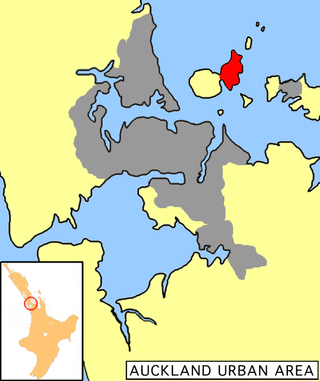
Motutapu Island is a 1,510 ha (3,700-acre) island in the Hauraki Gulf to the northeast of the city of Auckland, New Zealand. The island is part of the Hauraki Gulf Maritime Park. The island can be accessed via regular ferry services departing from Auckland City.

San Juan Island National Historical Park, also known as American and English Camps, San Juan Island, is a US National Historical Park owned and operated by the National Park Service on San Juan Island in the state of Washington. The park is made up of the sites of the British and U.S. Army camps during the Pig War, a boundary dispute over the ownership of the island. The camp sites were designated a National Historic Landmark in 1961, and listed on the National Register of Historic Places in 1966. The park was created by an act of Congress in 1966 and expanded slightly in 2013.

Middlesex Fells Reservation, often referred to simply as the Fells, is a public recreation area covering more than 2,200 acres (890 ha) in Malden, Medford, Melrose, Stoneham, and Winchester, Massachusetts, United States. The state park surrounds two inactive reservoirs, Spot Pond and the Fells Reservoir, and the three active reservoirs that are part of the water supply system for the town of Winchester. Spot Pond and the Fells Reservoir are part of the Wachusett water system, one of six primary water systems that feed metropolitan Boston's waterworks. The park is managed by the Massachusetts Department of Conservation and Recreation and is part of the Metropolitan Park System of Greater Boston.

Pymatuning State Park is a Pennsylvania state park covering 21,122 acres (8,548 ha) in Conneaut, North Shenango, Pine, Sadsbury, South Shenango, West Fallowfield and West Shenango Townships, Crawford County, Pennsylvania, in the United States. Pymatuning State Park is the largest state park in Pennsylvania and contains the 17,088 acres (69.15 km2) of Pymatuning Lake, three-quarters of which is in Pennsylvania and one-quarter of which is in Ohio. A 1.7-mile (2.7 km) causeway extends between Pennsylvania and Ohio near the center of the lake. The lake provides fishing and boating year round. There are two natural areas, Clark Island and Blackjack in the park. The park is also home to the University of Pittsburgh's Pymatuning Laboratory of Ecology. Like all Pennsylvania state parks, admission to the Pymatuning State Park is free. The northern access for Pymatuning State Park can be reached from U.S. Route 6 and the southern access is reached from U.S. Route 322.

The Lumber River, sometimes referred to as the Lumbee River, is a 133-mile-long (214 km) river in south-central North Carolina in the flat Coastal Plain. European settlers first called the river Drowning Creek, which is still used as the name of its headwater. The waterway known as the Lumber River extends downstream from the Scotland County-Hoke County border to the North Carolina-South Carolina border. Soon after crossing into South Carolina, the Lumber River flows into the Little Pee Dee River, which flows into the Pee Dee River, or Great Pee Dee River. Finally, the combined waters flow into Winyah Bay and the Atlantic Ocean.
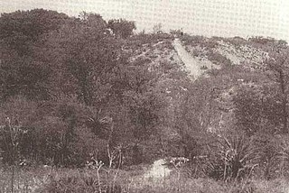
Mound Key Archaeological State Park is a Florida State Park, located in Estero Bay, near the mouth of the Estero River. One hundred and thirteen of the island's one hundred and twenty-five acres are managed by the park system. It is a complex of mounds and accumulated shell, fish bone, and pottery middens that rises more than 30 feet above the waters of the bay.
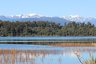
Lake Mahinapua is a shallow lake on the West Coast of New Zealand's South Island. Once a lagoon at the mouth of the Hokitika River, it became a lake when the river shifted its course. Lake Māhinapua was the site of a significant battle between Ngāi Tahu and Ngāti Wairangi Māori, and is regarded by them as a sacred site where swimming and fishing are prohibited. In European times it was part of an inland waterway that carried timber and settlers between Hokitika and Ross until the building of the railway. Today it is protected as a scenic reserve for boating, camping, and hiking.
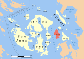
Cypress Island is the westernmost part of Skagit County, Washington, and is about halfway between the mainland and offshore San Juan County. It is separated from Blakely Island to the west by Rosario Strait and from Guemes Island to the east by Bellingham Channel. The island has a land area of 5,500 acres (22 km2), and a population of 40 persons as of the 2000 United States Census.

The Mohaka river is on the North Island of New Zealand in the east central region of Hawke’s Bay. Mohaka is a Maori word, roughly translated it means “place for dancing”. The iwi associated with the Mohaka River are Ngāti Pāhauwera, Ngāti Hineuru, Ngāti Tūwharetoa and Mana Ahuriri. The headwaters are found in the Kaweka and Kaimanawa ranges. From the range it winds southeast before twisting northeast and finally southeast again to empty into the Pacific Ocean near the town of Mohaka. There are many gorges on the Mohaka; some as steep as 200m. Its main tributaries are the Waipunga, Taharua, Hautapu rivers. The full length is 172 kilometres (107 mi) and it drains a basin of 2,357 square kilometres (910 sq mi). The Mohaka Viaduct is a railway bridge over the lower Mohaka river. The Napier–Taupo road has had several bridges over the upper Mohaka, with the current one built in 1962.

Green Head is a small Australian coastal town in the Shire of Coorow. The town is situated between Geraldton and Perth in the Mid West region of Western Australia along Indian Ocean Drive. Its beaches and lifestyle provide a relaxed holiday atmosphere. It is the home of what was a significant, but now declining, rock lobster industry.

Scandrett Regional Park is a regional park located on the north east tip of the Mahurangi Peninsula, north of the city of Auckland, New Zealand. It encompasses Mullet Point and includes regenerating coastal forest, rocky headlands that protrude into Kawau Bay, Scandretts Bay beach and a precinct of historic farm buildings. The people of Auckland own the park through the Auckland Council.
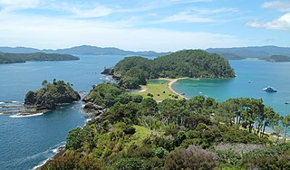
Motuarohia Island is a small island in the Bay of Islands of New Zealand, located about 4 kilometres (2.5 mi) northeast of Russell. The island stretches for 2 kilometres (1.2 mi) east-west, with the south coast offering two bays backed by sandy beaches. The north coast is dominated by steep cliffs in the west, rising to 78 metres (256 ft), and two shallow lagoons in the west. The twin lagoons nearly reach across the island to the bay on the south coast, almost bisecting the island.

Ulva Island-Te Wharawhara Marine Reserve is a marine reserve covering an area of 1,075 hectares south-west and north-east of Ulva Island, in the Paterson Inlet of New Zealand's Stewart Island. It was established in 2004 and is administered by the Department of Conservation.

Whitireia Park is a headland north of Tītahi Bay and Te Awarua-o-Porirua Harbour in Porirua, in the Wellington Region at the southern end of New Zealand's North Island. It is a park administered by the Whitireia Park Board, in collaboration with Wellington Regional Council. The park includes Onehunga Bay, Kaitawa Point and part of Rocky Bay.

Te Paepae o Aotea Marine Reserve is a marine reserve covering an area of 1,267 hectares in the Bay of Plenty of New Zealand's North Island. It includes an area around Te Paepae o Aotea, 55 kilometres (34 mi) north-northwest of Whakatāne and 5 kilometres (3.1 mi) northwest of Whakaari/White Island.


