"},"population_footnotes":{"wt":"{{NZ population data 2018||||y}}"},"population_as_of":{"wt":"{{NZ population data 2018|||y}}"},"population_total":{"wt":"{{NZ population data 2018|Waitangi (Far North district)|y}}"},"population_density_km2":{"wt":"auto"},"subdivision_type":{"wt":"[[List of sovereign states|Country]]"},"subdivision_name":{"wt":"New Zealand"},"subdivision_type1":{"wt":"[[Regions of New Zealand|Region]]"},"subdivision_name1":{"wt":"[[Northland Region]]"},"subdivision_type2":{"wt":"[[Districts of New Zealand|District]]"},"subdivision_name2":{"wt":"[[Far North District]]"},"subdivision_type3":{"wt":"Ward"},"subdivision_name3":{"wt":"Bay of Islands-Whangaroa"},"subdivision_type4":{"wt":"Community"},"subdivision_name4":{"wt":"Bay of Islands-Whangaroa"},"subdivision_type5":{"wt":"Subdivision"},"subdivision_name5":{"wt":"Paihia"},"leader_title":{"wt":"Territorial Authority"},"leader_name":{"wt":"[[Far North District Council]]"},"leader_title1":{"wt":"Regional council"},"leader_name1":{"wt":"[[Northland Regional Council]]"},"leader_title2":{"wt":"[[Mayor of Far North]]"},"leader_name2":{"wt":"{{NZ officeholder data|Far North District Mayor|y}}"},"leader_title3":{"wt":"[[Northland (New Zealand electorate)|Northland MP]]"},"leader_name3":{"wt":"{{NZ officeholder data|Northland MP|y}}"},"leader_title4":{"wt":"[[Te Tai Tokerau|Te Tai Tokerau MP]]"},"leader_name4":{"wt":"{{NZ officeholder data|Te Tai Tokerau MP|y}}"},"seat_type":{"wt":"Electorates"},"seat":{"wt":"{{ubl|[[Northland (New Zealand electorate)|Northland]]|[[Te Tai Tokerau]]}}"},"image_map":{"wt":"{{infobox mapframe|coord={{coord|35|15|58|S|174|4|48|E}}|zoom=10}}"},"coordinates":{"wt":"{{coord|35|15|58|S|174|4|48|E|region:NZ|display=inline}}"}},"i":0}}]}" id="mwCQ">Place in Northland Region, New Zealand
Waitangi | |
---|---|
![]() Te Whare Rūnanga, the carved meeting house on the Waitangi Treaty Grounds | |
![]() | |
Coordinates: 35°15′58″S174°4′48″E / 35.26611°S 174.08000°E | |
Country | New Zealand |
Region | Northland Region |
District | Far North District |
Ward | Bay of Islands-Whangaroa |
Community | Bay of Islands-Whangaroa |
Subdivision | Paihia |
Electorates | |
Government | |
• Territorial Authority | Far North District Council |
• Regional council | Northland Regional Council |
• Mayor of Far North | Moko Tepania |
• Northland MP | Grant McCallum |
• Te Tai Tokerau MP | Mariameno Kapa-Kingi |
Area | |
• Total | 17.19 km2 (6.64 sq mi) |
Population (June 2024) [2] | |
• Total | 60 |
• Density | 3.5/km2 (9.0/sq mi) |
Waitangi [a] is a locality on the north side of the Waitangi River in the Bay of Islands, 60 kilometres (37 miles) north of Whangārei, on the North Island of New Zealand. It is close to the town of Paihia, to which it is connected by a bridge near the mouth of the Waitangi River estuary. While Statistics New Zealand and NZ Post consider the southern boundary of Waitangi to be the river and estuary, with the area further south being part of Paihia, the area by Te Tī Bay, immediately south of the river, is sometimes referred to as part of Waitangi.
The Treaty of Waitangi was first signed at Waitangi on 6 February 1840. It is also the place where the Declaration of Independence of New Zealand was signed five years earlier, on 28 October 1835. This document was ratified by the British Crown the following year (1836).
"Waitangi" is a Māori-language name meaning "noisy waters" or "weeping waters", probably referring to the Haruru Falls on the Waitangi River. [5]
The Treaty of Waitangi proper began on 5 February 1840 when a public meeting was held on the grounds in front of James Busby's residence. Lieutenant Governor Hobson read a proposed document to the 300 or so European and Māori who were in attendance and then provided the Māori chiefs an opportunity to speak. Initially, a large number of chiefs (including Te Kemara, Rewa and Moka Te Kainga-mataa) spoke against accepting the Crown's proposition to rule over Aotearoa. [6] Later in the proceedings a few chiefs began to entertain the idea; amongst the more notable chiefs to support the Crown were Te Wharerahi, Pumuka, and the two Hokianga chiefs, Tāmati Wāka Nene and his brother Eruera Maihi Patuone. [6]
The proceedings were ended and were to recommence on 7 February; however, a number of chiefs pressed to sign earlier. The Treaty of Waitangi was initially signed on 6 February 1840 in a marquee erected in the grounds of James Busby's house at Waitangi by representatives of the British Crown, the chiefs of the Confederation of the United Tribes of New Zealand, and other Māori tribal leaders, and subsequently by other Māori chiefs at other places in New Zealand. Not all of the chiefs chose to sign this document, with a number of chiefs either delaying or refusing to put pen to paper.
In 2007, researcher Brent Kerehona claimed[ citation needed ] that uncertainty has arisen over whether Ngapuhi chief Moka Te Kainga-mataa actually signed; despite his name appearing on this document. A close inspection of the Treaty document itself shows no evidence of a signature or 'mark' next to Moka's name (which is written as 'Te Tohu o Moka'). Kerehona elaborates by inferring that it is clear by the accounts of Colenso (1890) [6] that not only did Moka clearly express his concerns about the Treaty's effects whilst at the meeting on February 5, but that the discussion that he had with the Reverend Charles Baker, combined with Moka's final comment, should be taken into account.
The Treaty of Waitangi followed on from The Declaration of Independence (He Whakaputanga) but did not render it void. [7]
Waitangi Treaty Grounds has been open to the public since 1934. [8] [9] What is now called the 'Treaty House' was first occupied by James Busby, who acted as the British resident in New Zealand from 1832 until the arrival of William Hobson, and his wife Agnes Busby. The Treaty House was restored in the 1930s, in preparation for New Zealand Centenary in 1940, sparking the first emergence of the Treaty into Pākehā attention since the 19th century.
Te Whare Rūnanga, a carved Māori meeting house, was built near the Treaty House in 1939 and opened on 6 February 1940. The area of the whare is sometimes used as if it is a marae and referred to as the "upper marae", although it is not a true marae. There is a marae, Te Tii Waitangi, in Te Tī Bay on the south side of the Waitangi River that is sometimes referred to as the "lower marae". [10]
Te Kōngahu Museum of Waitangi opened on the grounds in 2015. [11] [9] Another museum, Te Rau Aroha, opened in 2020. [12] [9]
In early November 2024, the Sixth National Government allocated NZ$10.2 million from the Regional Infrastructure Fund for building upgrades and repairs at the Waitangi Treaty Grounds. [13]
The Waitangi Wharf is at the mouth of the Waitangi River estuary, and is used by passenger ferry services between Russell and Paihia. [14] In 1990, artist Selwyn Muru requisitioned copper from the historic wharf piles, and incorporated these into Waharoa , a sculpture located in Aotea Square, Auckland. [15]
Statistics New Zealand describes Waitangi as a rural settlement. It covers 17.19 km2 (6.64 sq mi) [1] and had an estimated population of 60 as of June 2024, [2] with a population density of 3.5 people per km2. The settlement is part of the larger Puketona-Waitangi statistical area. [16]
Year | Pop. | ±% p.a. |
---|---|---|
2006 | 72 | — |
2013 | 66 | −1.24% |
2018 | 51 | −5.03% |
2023 | 57 | +2.25% |
Source: [17] [18] |
Waitangi had a population of 57 in the 2023 New Zealand census, an increase of 6 people (11.8%) since the 2018 census, and a decrease of 9 people (−13.6%) since the 2013 census. There were 39 males and 21 females in 39 dwellings. [19] 10.5% of people identified as LGBTIQ+. The median age was 33.8 years (compared with 38.1 years nationally). There were 9 people (15.8%) aged under 15 years, 12 (21.1%) aged 15 to 29, 24 (42.1%) aged 30 to 64, and 12 (21.1%) aged 65 or older. [18]
People could identify as more than one ethnicity. The results were 73.7% European (Pākehā), 15.8% Māori, and 15.8% Asian. English was spoken by 100.0%, and other languages by 21.1%. New Zealand Sign Language was known by 5.3%. The percentage of people born overseas was 26.3, compared with 28.8% nationally.
Religious affiliations were 26.3% Christian, 5.3% Hindu, 5.3% Māori religious beliefs, and 5.3% Buddhist. People who answered that they had no religion were 57.9%, and 10.5% of people did not answer the census question.
Of those at least 15 years old, 15 (31.2%) people had a bachelor's or higher degree, 24 (50.0%) had a post-high school certificate or diploma, and 6 (12.5%) people exclusively held high school qualifications. The median income was $42,000, compared with $41,500 nationally. 3 people (6.2%) earned over $100,000 compared to 12.1% nationally. The employment status of those at least 15 was that 33 (68.8%) people were employed full-time, and 6 (12.5%) were part-time. [18]
Climate data for Waitangi (1981–2010) | |||||||||||||
---|---|---|---|---|---|---|---|---|---|---|---|---|---|
Month | Jan | Feb | Mar | Apr | May | Jun | Jul | Aug | Sep | Oct | Nov | Dec | Year |
Mean daily maximum °C (°F) | 24.2 (75.6) | 24.3 (75.7) | 23.1 (73.6) | 20.7 (69.3) | 18.8 (65.8) | 16.6 (61.9) | 15.9 (60.6) | 16.1 (61.0) | 17.7 (63.9) | 19.1 (66.4) | 20.4 (68.7) | 22.8 (73.0) | 20.0 (68.0) |
Daily mean °C (°F) | 19.4 (66.9) | 20.0 (68.0) | 18.7 (65.7) | 16.5 (61.7) | 14.8 (58.6) | 12.3 (54.1) | 11.6 (52.9) | 12.0 (53.6) | 13.4 (56.1) | 14.5 (58.1) | 15.9 (60.6) | 18.2 (64.8) | 15.6 (60.1) |
Mean daily minimum °C (°F) | 14.7 (58.5) | 15.8 (60.4) | 14.3 (57.7) | 12.3 (54.1) | 10.8 (51.4) | 7.9 (46.2) | 7.2 (45.0) | 7.8 (46.0) | 9.0 (48.2) | 10.0 (50.0) | 11.4 (52.5) | 13.6 (56.5) | 11.2 (52.2) |
Average rainfall mm (inches) | 84.9 (3.34) | 125.5 (4.94) | 169.4 (6.67) | 120.7 (4.75) | 95.3 (3.75) | 140.3 (5.52) | 134.5 (5.30) | 119.1 (4.69) | 133.5 (5.26) | 115.4 (4.54) | 97.6 (3.84) | 88.0 (3.46) | 1,424.2 (56.06) |
Mean monthly sunshine hours | 229.4 | 176.8 | 163.5 | 148.4 | 145.6 | 112.9 | 142.5 | 142.2 | 161.5 | 206.8 | 174.6 | 199.9 | 2,004.1 |
Source: NIWA [20] |
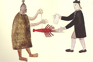
The Treaty of Waitangi, sometimes referred to as Te Tiriti, is a document of central importance to the history of New Zealand, its constitution, and its national mythos. It has played a major role in the treatment of the Māori people in New Zealand by successive governments and the wider population, something that has been especially prominent from the late 20th century. The treaty document is an agreement, not a treaty as recognised in international law. It was first signed on 6 February 1840 by Captain William Hobson as consul for the British Crown and by Māori chiefs from the North Island of New Zealand. The treaty's quasi-legal status satisfies the demands of biculturalism in contemporary New Zealand society. In general terms, it is interpreted today as having established a partnership between equals in a way the Crown likely did not intend it to in 1840. Specifically, the treaty is seen, first, as entitling Māori to enjoyment of land and of natural resources and, if that right were ever breached, to restitution. Second, the treaty's quasi-legal status has clouded the question of whether Māori had ceded sovereignty to the Crown in 1840, and if so, whether such sovereignty remains intact.
Waitangi Day, the national day of New Zealand, marks the anniversary of the initial signing—on 6 February 1840—of the Treaty of Waitangi. The Treaty of Waitangi was an agreement towards British sovereignty by representatives of the Crown and indigenous Māori chiefs, and so is regarded by many as the founding document of the nation.
The Declaration of the Independence of New Zealand, sometimes referred to as He Whakaputanga, is a document signed by a number of Māori chiefs in 1835, proclaimed the sovereign independence of New Zealand prior to the signing of the Treaty of Waitangi in 1840.
Russell, also known by the Māori name Kororāreka, is a town in the Bay of Islands, in New Zealand's far north. It was the first permanent European settlement and seaport in New Zealand.
Ngāpuhi is a Māori iwi associated with the Northland regions of New Zealand centred in the Hokianga, the Bay of Islands, and Whangārei.
Ngāti Whātua is a Māori iwi (tribe) of the lower Northland Peninsula of New Zealand's North Island. It comprises a confederation of four hapū (subtribes) interconnected both by ancestry and by association over time: Te Uri-o-Hau, Te Roroa, Te Taoū, Ngāti Whātua o Kaipara and Ngāti Whātua-o-Ōrākei. The five hapū can act together or separately as independent tribes.
Otakou is a settlement within the boundaries of the city of Dunedin, New Zealand. It is located 25 kilometres from the city centre at the eastern end of Otago Peninsula, close to the entrance of Otago Harbour. Though a small fishing village, Otakou is important in the history of Otago for several reasons. The settlement is the modern centre and traditional home of the Ōtākou rūnanga (assembly) of Ngāi Tahu. In 1946 Otakou Fisheries was founded in the township; this was later to become a major part of the Otago fishing industry.
Kawhia Harbour is one of three large natural inlets in the Tasman Sea coast of the Waikato region of New Zealand's North Island. It is located to the south of Raglan Harbour, Ruapuke and Aotea Harbour, 40 kilometres southwest of Hamilton. Kawhia is part of the Ōtorohanga District and is in the King Country. It has a high-tide area of 68 km2 (26 sq mi) and a low-tide area of 18 km2 (6.9 sq mi). Te Motu Island is located in the harbour.
Paihia is the main tourist town in the Bay of Islands in the Northland Region of the North Island of New Zealand. It is 60 kilometres north of Whangārei, located close to the historic towns of Russell and Kerikeri. Missionary Henry Williams named the mission station Marsden's Vale. Paihia eventually became the accepted name of the settlement.
The United Tribes of New Zealand was a confederation of Māori tribes based in the north of the North Island, existing legally from 1835 to 1840. It received diplomatic recognition from the United Kingdom, which shortly thereafter proclaimed the foundation of the Colony of New Zealand upon the signing of the Treaty of Waitangi.
The following lists events that happened during 1834 in New Zealand.
Kaeo is a township in the Far North District of New Zealand, located some 22 km (14 mi) northwest of Kerikeri. The town's name comes from the Māori-language name of the New Zealand freshwater mussel, which is found in nearby rivers.
Te Wharerahi was a highly respected rangatira (chief) of the Ipipiri area of New Zealand.
MokaKainga-mataa [Te Kaingamataa/Te Kaingamata/Te Kainga-mata/Te Kainga-mataa] (1790s–1860s) was a Māori rangatira (chief) of the Ngā Puhi iwi from Northland in New Zealand. He was distinguished in war and an intelligent participant in the Treaty of Waitangi process.
Waimate North is a small settlement in Northland, New Zealand. It is situated between Kerikeri and Lake Ōmāpere, west of the Bay of Islands.
Herekino is a locality in Northland, New Zealand. It lies 26 km south west of Kaitaia. The Herekino Harbour, also called the Herekino River, is an estuary and inlet from the Tasman Sea to the west. The Herekino Forest, which contains a stand of large kauri, is to the north, and the Tauroa Peninsula lies to the north west.
Waimā is a community in the south Hokianga area of Northland, New Zealand. State Highway 12 runs through the area. The Waima River flows through the Waima Valley into the Hokianga Harbour. Rawene is to the north west, and Kaikohe is to the north east.
Puketona is a locality at the junction of State Highway 10 and State Highway 11 in the Far North District of New Zealand. Kerikeri is 10 kilometres north, Paihia is 14 kilometres east, Moerewa is 15 kilometres southeast, and Kaikohe is 20 kilometres southwest.
The flag now known as the flag of theUnited Tribes of New Zealand or Te Kara is a flag originally designed by Henry Williams to represent the New Zealand Church Missionary Society. It was adopted as a national flag by a group of rangatira in 1834 and is today more closely associated with the Māori people.
Charles Frederick Baker was an English member of the Church Missionary Society (CMS) active as a missionary in New Zealand in the 19th century. He supervised the construction of the historic church at Russell and was involved in the Treaty of Waitangi proceedings, a collection consisting of his journals and papers was added to the UNESCO Memory of the World New Zealand register in 2018.
Media related to Waitangi at Wikimedia Commons