The national parks of New Zealand are protected areas administered by the Department of Conservation (DOC). Although the national parks contain some of New Zealand's most beautiful scenery, the first few established were all focused on mountain scenery. Since the 1980s the focus has been on developing a more diverse representation of New Zealand landscapes. The parks are all culturally significant and many also contain historic features. Tongariro National Park is one of the World Heritage Sites that are of both cultural and natural significance, while four of the South Island national parks form Te Wahipounamu, another World Heritage Site. There are currently 13 national parks; a 14th, Te Urewera National Park, was disestablished in 2014.

A swamp is a forested wetland. Swamps are considered to be transition zones because both land and water play a role in creating this environment. Swamps vary in size and are located all around the world. The water of a swamp may be fresh water, brackish water, or seawater. Freshwater swamps form along large rivers or lakes where they are critically dependent upon rainwater and seasonal flooding to maintain natural water level fluctuations. Saltwater swamps are found along tropical and subtropical coastlines. Some swamps have hammocks, or dry-land protrusions, covered by aquatic vegetation, or vegetation that tolerates periodic inundation or soil saturation. The two main types of swamp are "true" or swamp forests and "transitional" or shrub swamps. In the boreal regions of Canada, the word swamp is colloquially used for what is more correctly termed a bog, fen, or muskeg. Some of the world's largest swamps are found along major rivers such as the Amazon, the Mississippi, and the Congo.
Peat, sometimes known as turf, is an accumulation of partially decayed vegetation or organic matter. It is unique to natural areas called peatlands, bogs, mires, moors, or muskegs. The peatland ecosystem covers 3.7 million square kilometres and is the most efficient carbon sink on the planet, because peatland plants capture CO2 naturally released from the peat, maintaining an equilibrium. In natural peatlands, the "annual rate of biomass production is greater than the rate of decomposition", but it takes "thousands of years for peatlands to develop the deposits of 1.5 to 2.3 m [4.9 to 7.5 ft], which is the average depth of the boreal [northern] peatlands", which store around 415 gigatonnes of carbon (about 46 times 2019 global CO2 emissions). Globally, it even stores up to 550 gigatonnes of carbon, representing 42% of all soil carbon and exceeds the carbon stored in all other vegetation types, including the world's forests. Across the world, peat covers just 3% of the land’s surface, but stores one-third of the Earth’s soil carbon. Sphagnum moss, also called peat moss, is one of the most common components in peat, although many other plants can contribute. The biological features of sphagnum mosses act to create a habitat aiding peat formation, a phenomenon termed 'habitat manipulation'. Soils consisting primarily of peat are known as histosols. Peat forms in wetland conditions, where flooding or stagnant water obstructs the flow of oxygen from the atmosphere, slowing the rate of decomposition.

Resource depletion is the consumption of a resource faster than it can be replenished. Natural resources are commonly divided between renewable resources and non-renewable resources. Use of either of these forms of resources beyond their rate of replacement is considered to be resource depletion. The value of a resource is a direct result of its availability in nature and the cost of extracting the resource, the more a resource is depleted the more the value of the resource increases. There are several types of resource depletion, the most known being: Aquifer depletion, deforestation, mining for fossil fuels and minerals, pollution or contamination of resources, slash-and-burn agricultural practices, Soil erosion, and overconsumption, excessive or unnecessary use of resources.

Agathis australis, commonly known by its Māori name kauri, is a coniferous tree of Araucariaceae in the genus Agathis, found north of 38°S in the northern districts of New Zealand's North Island.
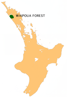
Waipoua Forest is a forest, on the west coast of the Northland Region of New Zealand's North Island. It preserves some of the best examples of kauri forest remaining in New Zealand. It is notable for having two of the largest living kauri trees, Tāne Mahuta and Te Matua Ngahere.

Sphagnum is a genus of approximately 380 accepted species of mosses, commonly known as "peat moss" though they are different as peat moss has a more acidic pH level. Accumulations of Sphagnum can store water, since both living and dead plants can hold large quantities of water inside their cells; plants may hold 16 to 26 times as much water as their dry weight, depending on the species. The empty cells help retain water in drier conditions.

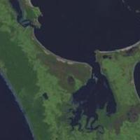
Kaipara Harbour is a large enclosed harbour estuary complex on the north western side of the North Island of New Zealand. The northern part of the harbour is administered by the Kaipara District and the southern part is administered by the Auckland Council. The local Māori tribe is Ngāti Whātua.
The Aupouri Peninsula is a tombolo at the northern tip of the North Island of New Zealand. It projects between the Tasman Sea to the west and the Pacific Ocean to the east. It constitutes the northern part of the Far North District, incorporating North Cape, Houhora and the northern half of Awanui.

Dacrycarpus dacrydioides or kahikatea is a coniferous tree endemic to New Zealand.
Marsden B was an unused 250 MW oil-fired power station near the Marsden Point Oil Refinery at Marsden Point, Ruakaka, Northland, New Zealand. Due to rising oil prices, the plant was mothballed in 1978 without ever being commissioned. The Marsden site also includes the Marsden A power station, now a synchronous compensation facility owned and operated by Mercury Energy.
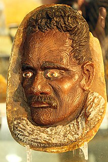
Kauri gum is a fossilised resin extracted from kauri trees, which is made into crafts such as jewellery. Kauri forests once covered much of the North Island of New Zealand, before Māori and European settlers caused deforestation, causing several areas to revert to sand dunes, scrubs, and swamps. Even afterward, ancient kauri fields continued to provide a source for the gum and the remaining forests.
New Zealand has several notable wetlands but 90% of wetland areas have been lost following European settlement.

The environment of New Zealand is characterised by an endemic flora and fauna which has evolved in near isolation from the rest of the world. The main islands of New Zealand span two biomes, temperate and subtropical, complicated by large mountainous areas above the tree line. There are also numerous smaller islands which extend into the subantarctic. The prevailing weather systems bring significantly more rain to the west of the country. New Zealand's territorial waters cover a much larger area than its landmass and extend over the continental shelf and abyssal plateau in the South Pacific Ocean, Tasman Sea and Southern ocean.

Swamp kauri, sometimes marketed as "ancient kauri", are prehistoric kauri trees, buried and preserved in peat up to 50,000 years ago in New Zealand's North Island. Buried under a peat swamp by an unexplained act of nature at the end of the last Ice Age, the trees have survived the centuries underground, sealed in a chemically balanced environment that has preserved the timber in perfect condition.

The Northland temperate kauri forests is an ecoregion in northern New Zealand, within the temperate broadleaf and mixed forests biome.

Deforestation in Borneo has taken place on an industrial scale since the 1960s. Borneo, the third largest island in the world, divided between Indonesia, Malaysia and Brunei, was once covered by dense tropical and subtropical rainforests.

Rangaunu Harbour is a shallow harbour in the far north of New Zealand. It is situated on the east coast at the base of the Aupouri Peninsula. The name in Māori means "To pull out a shoal of fish". With an area of 115 square kilometres (44 sq mi) it is the fifth-largest harbour in New Zealand.

The Whangamarino Wetland in the Waikato District is the second largest wetland complex of the North Island of New Zealand. Encompassing a total area of more than 7200 hectares, the Department of Conservation Te Papa Atawhai manages 5,923 hectares of peat bog, swamp, mesotrophic lags, open water and river systems listed as a wetland of international importance under the Ramsar Convention. Fish and Game New Zealand are the second largest landowner, managing 748 hectares of the wetland primarily as gamebird hunting habitat.

Corybas carsei, commonly known as the swamp helmet orchid, is a species of terrestrial orchid endemic to New Zealand. It is found only in Whangamarino Wetland in the Waikato District, where the population of fewer than 250 plants is critically endangered.