
The South Island, also officially named Te Waipounamu, is the larger of the two major islands of New Zealand in surface area, the other being the smaller but more populous North Island. It is bordered to the north by Cook Strait, to the west by the Tasman Sea, and to the south and east by the Pacific Ocean. The South Island covers 150,437 square kilometres (58,084 sq mi), making it the world's 12th-largest island. It has a temperate climate.

Mount Ruapehu is an active stratovolcano at the southern end of the Taupo Volcanic Zone in New Zealand. It is 23 kilometres (14 mi) northeast of Ohakune and 23 km (14 mi) southwest of the southern shore of Lake Taupo, within Tongariro National Park. The North Island's major ski resorts and only glaciers are on its slopes.

Lake Taupo is a lake in the North Island of New Zealand. It is in the caldera of the Taupo Volcano. With a surface area of 616 square kilometres (238 sq mi), it is the largest lake by surface area in New Zealand, and the second largest freshwater lake by surface area in geopolitical Oceania after Lake Murray in Papua New Guinea. Motutaiko Island lies in the south east area of the lake.

Queenstown is a resort town in Otago in the south-west of New Zealand's South Island. It has an urban population of 16,000.

Taupō, is a town on the shore of Lake Taupo, which occupies the caldera of the Taupo Volcano in the centre of the North Island of New Zealand. It is the seat of the Taupo District Council and lies in the southern Waikato Region.

The Waikato River is the longest river in New Zealand, running for 425 kilometres (264 mi) through the North Island. It rises in the eastern slopes of Mount Ruapehu, joining the Tongariro River system and flowing through Lake Taupo, New Zealand's largest lake. It then drains Taupo at the lake's northeastern edge, creates the Huka Falls, and flows northwest through the Waikato Plains. It empties into the Tasman Sea south of Auckland, at Port Waikato. It gives its name to the Waikato region that surrounds the Waikato Plains. The present course of the river was largely formed about 17,000 years ago. Contributing factors were climate warming, forest being reestablished in the river headwaters and the deepening, rather than widening, of the existing river channel. The channel was gradually eroded as far up river as Piarere, leaving the old Hinuera channel through the Hinuera Gap high and dry. The remains of the old river path can be clearly seen at Hinuera where the cliffs mark the ancient river edges. The river's main tributary is the Waipa River, which has its confluence with the Waikato at Ngāruawāhia.

Rotorua is a city on the southern shores of Lake Rotorua from which the city takes its name, located in the Bay of Plenty Region of New Zealand's North Island. It is the seat of the Rotorua Lakes District, a territorial authority encompassing Rotorua and several other nearby towns. The majority of the Rotorua District is in the Bay of Plenty Region, but a sizeable southern section and a small western section are in the Waikato region. Rotorua is in the heart of the North Island, 60 kilometres south of Tauranga, 80 km (50 mi) north of Taupō, 105 km (65 mi) east of Hamilton, and 230 km (140 mi) southeast of the nation's most populous city, Auckland.

Fiordland is a geographic region of New Zealand in the south-western corner of the South Island, comprising the western-most third of Southland. Most of Fiordland is dominated by the steep sides of the snow-capped Southern Alps, deep lakes, and its steep, glacier-carved and now ocean-flooded western valleys. The name "Fiordland" comes from a variant spelling of the Scandinavian word for this type of steep valley, "fjord". The area of Fiordland is dominated by, and very roughly coterminous with, Fiordland National Park, New Zealand's largest National Park.

Lake Wānaka is New Zealand's fourth-largest lake. In the Otago region, it is 278 meters above sea level, covers 192 km2 (74 sq mi), and is more than 300 m (980 ft) deep.
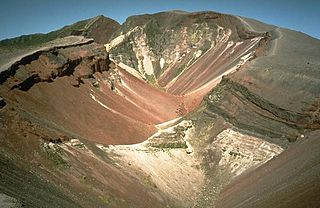
Mount Tarawera is a volcano on the North Island of New Zealand. Located 24 kilometres southeast of Rotorua, it consists of a series of rhyolitic lava domes that were fissured down the middle by an explosive basaltic eruption in 1886. This eruption was one of New Zealand's largest historical eruptions, and killed an estimated 120 people. The fissures run for about 17 kilometres northeast-southwest.

Wanaka, once called Pembroke, is a popular ski and summer resort town in the Otago region of the South Island of New Zealand. At the southern end of Lake Wānaka, it is at the start of the Clutha River and is the gateway to Mount Aspiring National Park.

The Waitaki River is a large braided river that drains the Mackenzie Basin and runs some 110 kilometres (68 mi) south-east to enter the Pacific Ocean between Timaru and Oamaru on the east coast of the South Island of New Zealand. It starts at the confluence of the Ohau River and the Tekapo River, now in the head of the artificial Lake Benmore, these rivers being fed by three large glacial lakes, Pukaki, Tekapo, and Ohau. The Waitaki flows through Lake Benmore, Lake Aviemore and Lake Waitaki, these lakes being contained by hydroelectric dams, Benmore Dam, Aviemore Dam and Waitaki Dam. The Waitaki has several tributaries, notably the Ahuriri River and the Hakataramea River. It passes Kurow and Glenavy before entering the Pacific Ocean.

Te Anau is a town in the Southland region of the South Island of New Zealand. It is on the eastern shore of Lake Te Anau in Fiordland. Lake Te Anau is the largest lake in the South Island and within New Zealand second only to Lake Taupo. The 2013 census recorded the town's population as 1,911. The town has a wide range of accommodation, with over 4,000 beds available in summer.

Lake Karapiro is an artificial reservoir lake on the Waikato River, 30 kilometres (19 mi) south-east of the city of Hamilton in New Zealand's North Island. The lake was formed in 1947 by damming the Waikato River to store water for the 96-megawatt Karapiro hydroelectric power station.

Queenstown-Lakes District, a local government district, is in the Otago Region of New Zealand that was formed in 1986. It is surrounded by the districts of Central Otago, Southland, Westland and Waitaki.

New Zealand is an island country in the southwestern Pacific Ocean. It consists of two main landmasses—the North Island and the South Island —and around 600 smaller islands, covering a total area of 268,021 square kilometres (103,500 sq mi). New Zealand is about 2,000 kilometres (1,200 mi) east of Australia across the Tasman Sea and 1,000 kilometres (600 mi) south of the islands of New Caledonia, Fiji, and Tonga. The country's varied topography and sharp mountain peaks, including the Southern Alps, owe much to tectonic uplift and volcanic eruptions. New Zealand's capital city is Wellington, and its most populous city is Auckland.

There are 3,820 lakes in New Zealand that have a surface area larger than one hectare. Many of the lakes in the central North Island are volcanic crater lakes. The majority of the lakes near the Southern Alps were carved by glaciers. Artificial lakes created as hydroelectric reservoirs are common in South Canterbury, Central Otago and along the Waikato River.
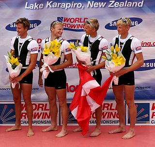
The 2010 World Rowing Championships were World Rowing Championships that were held from 31 October to 7 November 2010 on Lake Karapiro near Cambridge, New Zealand. The annual week-long rowing regatta was organised by FISA. Usually held at the end of the northern hemisphere summer, they were held later in the year in the southern hemisphere. In non-Olympic years the regatta is the highlight of the international rowing calendar.
