The South Wairarapa District is a district at the south-east tip of the North Island of New Zealand, governed by the South Wairarapa District Council. The district comprises the southernmost part of the Wairarapa, and is part of the Wellington Region.

The Thames-Coromandel District is a territorial authority district in the North Island of New Zealand, covering all the Coromandel Peninsula and extending south to Hikutaia.

Hauraki District is a territorial authority governed by the Hauraki District Council within the Waikato region of New Zealand. The seat of the council is at Paeroa.

Southland District is a New Zealand territorial authority district that covers most of the southern end of the South Island as well as Stewart Island.

The Far North District is the northernmost territorial authority district of New Zealand, consisting of the northern part of the Northland Peninsula in the North Island. It stretches from North Cape / Otou and Cape Reinga / Te Rerenga Wairua in the north, down to the Bay of Islands, the Hokianga and the town of Kaikohe.

Central Otago District is local government district in New Zealand. It is administered by the Central Otago District Council, and it is in the Otago region, the top tier of local government in New Zealand. The major towns in the district are Alexandra, Cromwell, Roxburgh, Clyde and Ranfurly. The district covers 9,968 km2 (3,849 sq mi), making it the fourth-largest district in New Zealand by area, and is home to 26,500 people as of June 2024.

Mackenzie District is a local government district on New Zealand's South Island, administered by the Mackenzie District Council. It is part of the larger Canterbury Region. The region takes its name from the Mackenzie Basin, an elliptical intermontane basin which covers much of inland Canterbury.

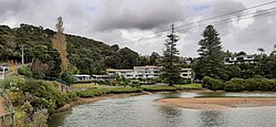
Opua is a locality in the Bay of Islands, in the sub-tropical Northland Region of New Zealand. It is notable as the first port for overseas yachts arriving in the country after crossing the Pacific Ocean. In the original 1870s plans for the town, it was named Newport. The town of Paihia is nearby, and the small settlement of Te Haumi is in between.

Herekino is a locality in Northland, New Zealand. It lies 26 km south west of Kaitaia. The Herekino Harbour, also called the Herekino River, is an estuary and inlet from the Tasman Sea to the west. The Herekino Forest, which contains a stand of large kauri, is to the north, and the Tauroa Peninsula lies to the north west.
Kaingaroa is a locality in the Far North District of New Zealand. It lies on State Highway 10 north-east of Awanui and Kaitaia, and south-west of Karikari Peninsula.

Matihetihe is a community in the Hokianga area of Northland, New Zealand. The Warawara Forest lies to the north. The Matihetihe Stream runs into the Tasman Sea to the west. The locality is named for the tihetihe tumbleweed that grows in the local sand dunes.
Pukepoto is a town in Northland, New Zealand. It lies south west of Kaitaia and north east of Ahipara. The Herekino Forest lies to the south east.
Waikare is a locality in Northland, New Zealand. The Waikare River flows from the Russell Forest past Waikare and into the Waikare Inlet, which leads into the Bay of Islands.
Panguru is a community in the northern Hokianga harbour, in Northland, New Zealand. The Whakarapa Stream flows from the Panguru Range in the Warawara Forest to the west, through Panguru and into the Hokianga.
Rawhiti is a small beachfront town about 27km from Russell in the Bay of Islands of New Zealand.

Wairoa District is a territorial authority district within the Hawke's Bay Region in the North Island of New Zealand. The Wairoa District Council is headquartered in the largest town, Wairoa. The district covers the northern half of the Hawke's Bay coast, extending from Māhia Peninsula to Lake Waikaremoana, and south to the mouth of the Waikare River.

Taupō Bay is a bay, village and rural community in the Far North District and Northland Region of New Zealand's North Island. There are about 40 permanent residents, and 180 properties. The white sand beach is 1.5 km wide.

Takahue is a rural community in the Far North District and Northland Region of New Zealand's North Island, south of Kaitaia.
Whakatāne District is a territorial authority district on the North Island of New Zealand. The Whakatāne District Council is headquartered in the largest town, Whakatāne. The district falls within the Bay of Plenty Region. Victor Luca has been the mayor of Whakatāne since the 2022 local elections.
Kapiro is a locality in the Far North District of Northland, New Zealand. State Highway 10 passes through Kapiro. Waipapa is 2.7 km south, and Kaeo is 19 km northwest, by road.