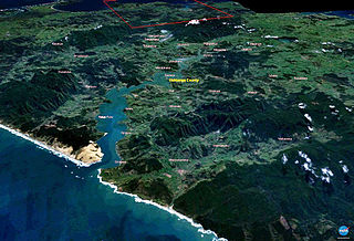
The Hokianga is an area surrounding the Hokianga Harbour, also known as the Hokianga River, a long estuarine drowned valley on the west coast in the north of the North Island of New Zealand.

Dargaville is a town located in the North Island of New Zealand. It is situated on the bank of the Northern Wairoa River in the Kaipara District of the Northland region. Dargaville is located 55 kilometres (34 mi) southwest of Whangārei, and 174 kilometres (108 mi) north of Auckland.

The Far North District is the northernmost territorial authority district of New Zealand, consisting of the northern part of the Northland Peninsula in the North Island. It stretches from North Cape / Otou and Cape Reinga / Te Rerenga Wairua in the north, down to the Bay of Islands, the Hokianga and the town of Kaikohe.

Rangiahua is a small locality near the Hokianga Harbour in the Northland Region of New Zealand. State Highway 1 passes through it. Umawera is to the west, and Okaihau to the east. Rangiahua is part of the Omahuta Forest-Horeke statistical area, which covers the upper Hokianga Harbour. For demographics of this area, see Horeke.

Kohukohu is a village on the Hokianga Harbour in the Northland Region of New Zealand. It was one of the first European settlements in New Zealand.

Herekino is a locality in Northland, New Zealand. It lies 26 km south west of Kaitaia. The Herekino Harbour, also called the Herekino River, is an estuary and inlet from the Tasman Sea to the west. The Herekino Forest, which contains a stand of large kauri, is to the north, and the Tauroa Peninsula lies to the north west.

Horeke is a settlement in the upper reaches of the Hokianga Harbour in Northland, New Zealand. Kohukohu is just across the harbour. The Horeke basalts are located near the town, and can be viewed on an easy stroll through the Wairere Boulders, a commercial park.
Mangamuka is a district in Northland, New Zealand, at the junction of the Mangamuka and Opurehu Rivers. State Highway 1 runs through the area, and the settlement of Mangamuka Bridge lies at the point where the highway crosses the Mangamuku River. The river runs into the upper Hokianga Harbour. Just to the north west, the highway runs through Mangamuka Gorge in the Maungataniwha Range. Umawera lies to the south east.
Omanaia is a settlement in the Hokianga area of Northland, New Zealand. It is part of the Hokianga South statistical area, which covers the southern side of Hokianga Harbour between Rawene and Koutu. For demographics of this area, see Rawene.
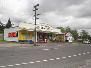
Broadwood is a town about 25 km to the north of the north side of the Hokianga harbour, in Northland, New Zealand. Herekino is 21 km to the west, and Mangamuka Bridge is the same distance to the east.
Whirinaki is a locality on the Whirinaki River in the south Hokianga, in Northland, New Zealand. The name means "to lean against a support". Highway 12 runs through it. Opononi lies to the south west, and Rawene lies to the north east.

Whangape Harbour is a harbour on the west coast of Northland, New Zealand. There is a settlement called Whangape on the northern side of the harbour. Another, called Pawarenga, is located on the southern side. Kaitaia is 42 km north east.

Whangaroa Harbour, previously spelled Wangaroa Harbour, is an inlet on the northern coast of Northland, New Zealand. Whangaroa Bay and the Pacific Ocean are to the north. The small settlements of Totara North and Saies are on the west side of the harbour, Waitaruke on the south side, and Whangaroa on the east. State Highway 10 runs through Waitaruke. The name comes from the lament "Whaingaroa" or "what a long wait" of a woman whose warrior husband had left for a foray to the south. The harbour was formed when rising sea levels drowned a river valley about 6,000 years ago. Steep outcrops remain from ancient volcanic rocks.
Panguru is a community in the northern Hokianga harbour, in Northland, New Zealand. The Whakarapa Stream flows from the Panguru Range in the Warawara Forest to the west, through Panguru and into the Hokianga.
Umawera is a community in Northland, New Zealand. State Highway 1 runs through the community. Mangamuka Bridge is to the northwest, and Rangiahua is to the east. Umawera is part of the Omahuta Forest-Horeke statistical area, which covers the upper Hokianga Harbour. For demographics of this area, see Horeke.
Waimā is a community in the south Hokianga area of Northland, New Zealand. State Highway 12 runs through the area. The Waima River flows through the Waima Valley into the Hokianga Harbour. Rawene is to the north west, and Kaikohe is to the north east.
Aranga is a locality in Northland, New Zealand. State Highway 12 passes through it. Ōmāpere is 47 km northwest, and Dargaville is 42 km southeast. The Waipoua Forest is to the north. Maunganui Bluff and the Tasman Sea are to the west, with the small settlement of Aranga Beach lying at the northern end of Ripiro Beach.
Te Rarawa is a Māori iwi of Northland, New Zealand. The iwi is one of five Muriwhenua iwi of the far north of the North Island.
Waimamaku is a village and rural community, based along the banks of the Waimamaku River south of the Hokianga Harbour on the west coast of New Zealand's North Island. It is located in the Far North District and Northland Region on State Highway 12, south of Ōmāpere and north of Waipoua.
Mitimiti is a small settlement in Northland, New Zealand. It lies close to the Warawara Forest, between the mouths of the Whangape Harbour and Hokianga Harbour on Northland's west coast, 44 km west of Kohukohu. Mitimiti is part of the Hokianga North statistical area. For demographics of this area, see Panguru.
