Horeke (Māori: Hōreke) is a settlement in the upper reaches of the Hokianga Harbour in Northland, New Zealand. Kohukohu is just across the harbour. The Horeke basalts are located near the town, and can be viewed on an easy stroll through the Wairere Boulders, a commercial park.[3]
The town was initially called Deptford after the Royal Navy shipyard in England.[6] It was one of the first places settled by Europeans in New Zealand, with shipbuilding established in the late 1820s.[7]
David Ramsay and Gordon Davies Browne came from Sydney to set up a trading post and shipbuilding settlement about 1826.[8] Three ships were built - a 40-ton schooner called Enterprise, a 140-ton brigantine called New Zealander, and the 394 (or 392)-ton barque Sir George Murray,[9][10] but the firm went bankrupt in 1830.[11]
In October 2020, the Government committed $441,900 from the Provincial Growth Fund to upgrade Mataitaua Marae, creating 10 jobs. It also committed $496,514 to upgrade the Puketawa Marae, creating 22 jobs.[16]
The Maraeroa community, east of Horeke, has two Ngāpuhi marae:[14]
In October 2020, the Government committed $471,100 to upgrade Rangatahi Marae, creating 15 jobs.[16]
Demographics
The SA1 statistical area which includes Horeke covers 12.35km2 (4.77sqmi).[1] The SA1 area extends to the Utukura River and Ruapapaka Island, and is part of the larger Omahuta Forest-Horeke statistical area.
Historical population for Horeke and surrounds
Year
Pop.
±% p.a.
2001
171
—
2006
108
−8.78%
2013
114
+0.78%
2018
150
+5.64%
2023
162
+1.55%
Populations before 2013 are for the equivalent meshblock 0022000. Source: [2]
The SA1 statistical area had a population of 162 in the 2023 New Zealand census, an increase of 12 people (8.0%) since the 2018 census, and an increase of 48 people (42.1%) since the 2013 census. There were 81 males, 81 females and 3 people of other genders in 51 dwellings.[17] 1.9% of people identified as LGBTIQ+. The median age was 36.8 years (compared with 38.1 years nationally). There were 39 people (24.1%) aged under 15 years, 30 (18.5%) aged 15 to 29, 75 (46.3%) aged 30 to 64, and 21 (13.0%) aged 65 or older.[2]
People could identify as more than one ethnicity. The results were 31.5% European (Pākehā), 88.9% Māori, 5.6% Pasifika, and 1.9% Asian. English was spoken by 94.4%, Māori language by 33.3%, Samoan by 3.7% and other languages by 3.7%. New Zealand Sign Language was known by 1.9%. The percentage of people born overseas was 7.4, compared with 28.8% nationally.
Religious affiliations were 33.3% Christian, and 16.7% Māori religious beliefs. People who answered that they had no religion were 42.6%, and 9.3% of people did not answer the census question.
Of those at least 15 years old, 3 (2.4%) people had a bachelor's or higher degree, 66 (53.7%) had a post-high school certificate or diploma, and 51 (41.5%) people exclusively held high school qualifications. The median income was $23,200, compared with $41,500 nationally. The employment status of those at least 15 was that 27 (22.0%) people were employed full-time, 12 (9.8%) were part-time, and 12 (9.8%) were unemployed.[2]
Omahuta Forest-Horeke
Omahuta Forest-Horeke covers the upper Hokianga Harbour. It has an area of 463.71km2 (179.04sqmi)[1] and had an estimated population of 1,190 as of June 2024,[18] with a population density of 2.6 people per km2.
Omahuta Forest-Horeke had a population of 1,143 in the 2023 New Zealand census, an increase of 87 people (8.2%) since the 2018 census, and an increase of 255 people (28.7%) since the 2013 census. There were 567 males, 564 females and 9 people of other genders in 387 dwellings.[21] 1.8% of people identified as LGBTIQ+. The median age was 41.5 years (compared with 38.1 years nationally). There were 255 people (22.3%) aged under 15 years, 183 (16.0%) aged 15 to 29, 504 (44.1%) aged 30 to 64, and 198 (17.3%) aged 65 or older.[20]
People could identify as more than one ethnicity. The results were 53.3% European (Pākehā), 67.5% Māori, 6.8% Pasifika, 2.1% Asian, and 1.6% other, which includes people giving their ethnicity as "New Zealander". English was spoken by 96.3%, Māori language by 21.5%, Samoan by 1.0% and other languages by 3.1%. No language could be spoken by 1.8% (e.g. too young to talk). New Zealand Sign Language was known by 0.3%. The percentage of people born overseas was 8.4, compared with 28.8% nationally.
Religious affiliations were 30.7% Christian, 12.1% Māori religious beliefs, 0.3% Buddhist, 0.5% New Age, and 0.8% other religions. People who answered that they had no religion were 46.5%, and 9.4% of people did not answer the census question.
Of those at least 15 years old, 63 (7.1%) people had a bachelor's or higher degree, 510 (57.4%) had a post-high school certificate or diploma, and 291 (32.8%) people exclusively held high school qualifications. The median income was $26,300, compared with $41,500 nationally. 27 people (3.0%) earned over $100,000 compared to 12.1% nationally. The employment status of those at least 15 was that 330 (37.2%) people were employed full-time, 117 (13.2%) were part-time, and 66 (7.4%) were unemployed.[20]
Education
Horeke School is a coeducational contributing primary (years 1-8) school[22] which had a roll of 20 students as of August 2024.[23] The school was established in 1920.[24]
Tasman District is a local government district in the northwest of the South Island of New Zealand. It borders the Canterbury Region, West Coast Region, Marlborough Region and Nelson City. It is administered by the Tasman District Council, a unitary authority, which sits at Richmond, with community boards serving outlying communities in Motueka and Golden Bay / Mohua. The city of Nelson has its own unitary authority separate from Tasman District, and together they comprise a single region in some contexts, but not for local government functions or resource management (planning) functions.
Kaitaia is a town in the Far North District of New Zealand, at the base of the Aupōuri Peninsula, about 160 km northwest of Whangārei. It is the last major settlement on State Highway 1. Ahipara Bay, the southern end of Te Oneroa-a-Tōhē / Ninety Mile Beach, is 5 kilometres (3.1 mi) west.
South Waikato District is a local government district in the Waikato Region of the North Island of New Zealand. It is located between the cities of Hamilton to the north, Rotorua to the east, Taupō to the south and Ruapehu District to the west.
Kawerau is a town in the Bay of Plenty Region on the North Island of New Zealand. It is situated 100 km south-east of Tauranga and 58 km east of Rotorua. It is the seat of the Kawerau District Council, and the only town in Kawerau District.
The Far North District is the northernmost territorial authority district of New Zealand, consisting of the northern part of the Northland Peninsula in the North Island. It stretches from North Cape / Otou and Cape Reinga / Te Rerenga Wairua in the north, down to the Bay of Islands, the Hokianga and the town of Kaikohe.
Taipa-Mangonui or Taipa Bay-Mangonui is a string of small resort settlements – Taipa, Cable Bay, Coopers Beach, and Mangōnui – that lie along the coast of Doubtless Bay and are so close together that they have run together to form one larger settlement.
Matauri Bay is a bay in New Zealand, situated 30 km north of Kerikeri, in Whangaroa county, just north of the Bay of Islands. It has over a kilometre of white sand and crystal clear water, making it a popular summer destinations for surfers, divers, fishers and holidaymakers.
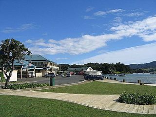
Kohukohu is a village on the Hokianga Harbour in the Northland Region of New Zealand. It was one of the first European settlements in New Zealand.
Kaeo is a township in the Far North District of New Zealand, located some 22 km (14 mi) northwest of Kerikeri. The town's name comes from the Māori-language name of the New Zealand freshwater mussel, which is found in nearby rivers.
Herekino is a locality in Northland, New Zealand. It lies 26 km south west of Kaitaia. The Herekino Harbour, also called the Herekino River, is an estuary and inlet from the Tasman Sea to the west. The Herekino Forest, which contains a stand of large kauri, is to the north, and the Tauroa Peninsula lies to the north west.
Peria is a locality in Northland, New Zealand. It lies south of Taipa and east of Kaitaia. The area was once known as Oruru Valley.
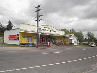
Broadwood is a town about 25 km to the north of the north side of the Hokianga harbour, in Northland, New Zealand. Herekino is 21 km to the west, and Mangamuka Bridge is the same distance to the east.
Pukepoto is a town in Northland, New Zealand. It lies south west of Kaitaia and north east of Ahipara. The Herekino Forest lies to the south east.
The Karikari Peninsula on the east coast of the far north of Northland, New Zealand, is between Rangaunu Harbour to the west, and Doubtless Bay to the southeast. It is a right-angled land mass of two relatively distinct parts. The rocky northern part, which has an east–west orientation and is approximately 17 km long, was originally an island but is now connected to the mainland by a low sandy tombolo approximately 11 km long, which has a north–south orientation. The spiritually significant Puwheke sits high above the north-facing beaches.
Whangape Harbour is a harbour on the west coast of Northland, New Zealand. There is a settlement called Whangape on the northern side of the harbour. Another, called Pawarenga, is located on the southern side. Kaitaia is 42 km north east.
Panguru is a community in the northern Hokianga harbour, in Northland, New Zealand. The Whakarapa Stream flows from the Panguru Range in the Warawara Forest to the west, through Panguru and into the Hokianga.
Hihi or Hihi Beach is a village and rural community in the Far North District and Northland Region of New Zealand's North Island.
Mangōnui is a settlement on the west side of Mangōnui Harbour in Northland, New Zealand. State Highway 10 runs through it. It is the easternmost of the Taipa-Mangonui string of settlements, separated from Coopers Beach to the northwest by Mill Bay Road.
Taupō Bay is a bay, village and rural community in the Far North District and Northland Region of New Zealand's North Island. There are about 40 permanent residents, and 180 properties. The white sand beach is 1.5 km wide.
Takahue is a rural community in the Far North District and Northland Region of New Zealand's North Island, south of Kaitaia.
This page is based on this Wikipedia article Text is available under the CC BY-SA 4.0 license; additional terms may apply. Images, videos and audio are available under their respective licenses.