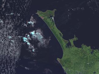
Waipapakauri

Last updated

Waipapakauri
Waipapakauri
Coordinates: 35°01′30″S173°13′30″E / 35.02500°S 173.22500°E / -35.02500; 173.22500 Coordinates: 35°01′30″S173°13′30″E / 35.02500°S 173.22500°E / -35.02500; 173.22500
CountryNew Zealand
Region Northland Region
District Far North District
WardTe Hiku
Electorates
Government
  Territorial Authority Far North District Council
  Regional council Northland Regional Council
Area
[1]
  Total9.64 km2 (3.72 sq mi)
Population
 (2018 census) [2]
  Total186
  Density19/km2 (50/sq mi)

Waipapakauri is a small settlement in the Far North District of New Zealand. It is located on State Highway 1 at the isthmus of the Aupouri Peninsula. The larger settlement of Awanui lies to the southeast. Waipapakauri is some 12 kilometres to the north of Kaitaia, the nearest town.

Contents

The small Waipapakauri Creek crosses SH1 just to the east, flowing north to reach the broad mudflats of Rangaunu Harbour. Several small lakes lie to the southwest of the settlement, the largest of them being Lake Ngatu. Waipapakauri is located close to Ninety Mile Beach and has long beek known for shellfish harvesting. [3] Flax milling was also formerly carried out at Waipapakauri. The settlement was the site of an airforce base, RNZAF Station Waipapakauri, during World War II.

The name Waipapakauri is Māori for "Swamp where the kauri grow". [4]

Noted people connected with Waipapakauri include former All Blacks Percy Erceg (who was born in the settlement), Peter Jones (who spent his last years there), former MP John Carter is a resident of Waipapakauri and Edward Te Whiu, 82nd person to be judicially executed in New Zealand.

History

Waipapakauri was an important location for the late 19th/early 20th century kauri gum digging trade. In the 1910s, the lower quality chip gum found at the southern half of the Aupouri Peninsula greatly increased in value. [5]

Demographics

The SA1 statistical area which includes Waipapakauri covers 9.64 km2 (3.72 sq mi). [1] The SA1 area is part of the larger Rangaunu Harbour statistical area. [6]

Historical population
YearPop.±% p.a.
2006168    
2013168+0.00%
2018186+2.06%
Source: [2]

7000024 had a population of 186 at the 2018 New Zealand census, an increase of 18 people (10.7%) since the 2013 census, and an increase of 18 people (10.7%) since the 2006 census. There were 57 households, comprising 96 males and 90 females, giving a sex ratio of 1.07 males per female. The median age was 35.4 years (compared with 37.4 years nationally), with 42 people (22.6%) aged under 15 years, 39 (21.0%) aged 15 to 29, 75 (40.3%) aged 30 to 64, and 27 (14.5%) aged 65 or older.

Ethnicities were 61.3% European/Pākehā, 69.4% Māori, 3.2% Pacific peoples, and 8.1% Asian. People may identify with more than one ethnicity.

Of those people who chose to answer the census's question about religious affiliation, 53.2% had no religion, 29.0% were Christian, 1.6% were Buddhist and 6.5% had Māori religious beliefs.

Of those at least 15 years old, 9 (6.2%) people had a bachelor or higher degree, and 42 (29.2%) people had no formal qualifications. The median income was $22,800, compared with $31,800 nationally. 6 people (4.2%) earned over $70,000 compared to 17.2% nationally. The employment status of those at least 15 was that 69 (47.9%) people were employed full-time, 18 (12.5%) were part-time, and 15 (10.4%) were unemployed. [2]

Related Research Articles

<span class="mw-page-title-main">Katikati</span> Town in the Bay of Plenty, New Zealand

Katikati is a town in New Zealand located on the Uretara Stream near a tidal inlet towards the northern end of Tauranga Harbour, 28 kilometres south of Waihi and 40 kilometres northwest of Tauranga. State Highway 2 passes through the town; a bypass scheduled to have begun construction in 2008 is on hold.

<span class="mw-page-title-main">Helensville</span> Place in Auckland, New Zealand

Helensville is a town in the North Island of New Zealand. It is sited 40 kilometres (25 mi) northwest of Auckland, close to the southern extremity of the Kaipara Harbour. State Highway 16 passes through the town, connecting it to Waimauku 16 kilometres (10 mi) to the south, and Kaukapakapa about 12 kilometres (7.5 mi) to the north-east. Parakai is two kilometres (1.2 mi) to the north-west.

<span class="mw-page-title-main">Aupouri Peninsula</span> Northernmost peninsula of New Zealand

The Aupouri Peninsula is a tombolo at the northern tip of the North Island of New Zealand. It projects between the Tasman Sea to the west and the Pacific Ocean to the east. It constitutes the northern part of the Far North District, incorporating North Cape, Houhora and the northern half of Awanui.

<span class="mw-page-title-main">Riverhead, New Zealand</span> Place in Auckland Region, New Zealand

Riverhead is a small, historically predominantly working-class town located at the head of the Waitematā Harbour in the north-west of Auckland, New Zealand. The region around Riverhead and the neighbouring towns of Kumeu and Huapai is known for its vineyards. This town has had its 15 minutes in the spotlight appearing in movies Bridge to Terabithia and Crooked Earth and the odd television show such as Outrageous Fortune. The region features a pine plantation forest that is popular with horse riders, mountain bikers and motorcyclists. Riverhead Forest is operated by Matariki Forests, under Crown Licence. The forest was originally planted on poor kauri gum fields.

<span class="mw-page-title-main">Whangateau</span> Place in Auckland Region, New Zealand

Whangateau is a small town on the east coast of the North Island of New Zealand. It is situated in Rodney District, part of the Auckland Region, and is on a peninsula stretching out into the Hauraki Gulf, north of Auckland. Whangateau is on the northern shore of Whangateau Harbour which is fed by the Omaha River and separated from Omaha Bay by the Maungatawhiri sandspit. The settlement is in two parts of 20 to 30 houses each. The main settlement includes a large public reserve with sports fields and a campground. There is also a public hall which hosts music events and a flax weaving group. The smaller settlement is Tram Car Bay, named for two tram cars which were used as holiday homes. Whangateau is situated between the rural settlement of Matakana and the fishing village of Leigh. A tsunami siren is located in the town.

<span class="mw-page-title-main">Whangaroa</span> Place in Northland Region, New Zealand

Whangaroa, also known as Whangaroa Village to distinguish it the larger area of the former Whangaroa County, is a settlement on Whangaroa Harbour in the Far North District of New Zealand. It is 8 km north-west of Kaeo and 35 km north-west of Kerikeri. The harbour is almost landlocked and is popular both as a fishing spot in its own right and as a base for deep-sea fishing.

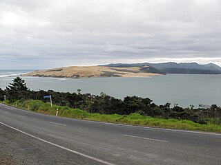
Awanui is an historical river port in the far north of New Zealand, on the banks of the Awanui River just before it flows into Rangaunu Bay. Awanui lies at the south end of the Aupouri Peninsula in the Far North District Council of the Northland Region, approximately 7 km north of Kaitaia. The river port has ceased operation and a recreational wharf is located at Unahi, on the shore of Rangaunu Bay, approximately 3 km north of the township. The traditional name of Awanui was Kaiwaka and Awanui proper refers to the "River at Kaiwaka". According to the 2013 New Zealand census, Awanui has a population of 339, a decrease of 9 people since the 2006 census.

<span class="mw-page-title-main">Herekino</span> Place in Northland Region, New Zealand

Herekino is a locality in Northland, New Zealand. It lies 26 km south west of Kaitaia. The Herekino Harbour, also called the Herekino River, is an estuary and inlet from the Tasman Sea to the west. The Herekino Forest, which contains a stand of large kauri, is to the north, and the Tauroa Peninsula lies to the north west.

<span class="mw-page-title-main">Houhora</span> Place in Northland Region, New Zealand

Houhora is a locality and harbour on the east side of the Aupouri Peninsula of Northland, New Zealand. It is 41 km (25 mi) north of Kaitaia. Waihopo, Te Raupo, Pukenui, Raio and Houhora Heads are associated localities on the southern shores of the harbour. State Highway 1 passes through all these localities except for Houhora Heads. Te Kao is 24 km north west, and Waiharara is 22 km south east.

<span class="mw-page-title-main">Te Kao</span> Place in Northland Region, New Zealand

Te Kao is a village on the Aupouri Peninsula of Northland, New Zealand. Te Aupōuri are mana whenua over Te Kao and the surrounding district, and it is the principal settlement of the iwi (tribe). Te Aupōuri's Post-Settlement Governance Entity, Te Runanga Nui o Te Aupōuri, has an office at Te Kao, along with the iwi's marae and urupa. State Highway 1 passes through the district. Cape Reinga is 46 km to the north, and Houhora is 24 km to the south. The Aupouri Forest and Ninety Mile Beach are to the west.

<span class="mw-page-title-main">Whangape Harbour</span> Body of water

Whangape Harbour is a harbour on the west coast of Northland, New Zealand. There is a settlement called Whangape on the northern side of the harbour. Another, called Pawarenga, is located on the southern side. Kaitaia is 42 km north east.

Panguru is a community in the northern Hokianga harbour, in Northland, New Zealand. The Whakarapa Stream flows from the Panguru Range in the Warawara Forest to the west, through Panguru and into the Hokianga.

Waiharara is a community at the base of the Aupouri Peninsula in Northland, New Zealand. State Highway 1 runs through the community. To the west is Aupouri Forest, and beyond that Ninety Mile Beach. To the east is Rangaunu Harbour. Houhora is 22 km north west, and Awanui is 16 km south east. Lake Waiparera, 35 metres above sea level, is immediately to the north west.

<span class="mw-page-title-main">Matakohe</span> Place in Northland Region, New Zealand

Matakohe is a settlement in Northland, New Zealand. The Matakohe River is a short river which runs from the north into the Arapaoa River, which is part of the Kaipara Harbour. State Highway 12 passes through Matakohe. Ruawai is 16 km to the west, and Paparoa is 6 km north east. The Hukatere Peninsula extends south into the Kaipara Harbour.

<span class="mw-page-title-main">Tinopai</span> Place in Northland Region, New Zealand

Tinopai is a settlement on the Komiti Bay, part of the Hukatere Peninsula in the northern Kaipara Harbour in Northland, New Zealand. The Otamatea River flows from the north east past Tinopai and into the harbour. Matakohe is 23 km (14 mi) to the north.

Marsden Bay is a locality and bay at the south head of Whangārei Harbour in Northland, New Zealand. The western side of Marsden Bay is a coastal community called One Tree Point, and the eastern side is the industrial development of Marsden Point. Ruakākā lies about 9 km to the south.

Rangaunu Harbour is a shallow harbour in the far north of New Zealand. It is situated on the east coast at the base of the Aupouri Peninsula. The name in Māori means "To pull out a shoal of fish". With an area of 115 square kilometres (44 sq mi) it is the fifth-largest harbour in New Zealand.

Paparore is a small coastal settlement near the north of Waipapakauri, adjacent to Rangaunu Harbour. It has a marae and cemetery.

Kaimaumau is a locality on the northeast side of Rangaunu Harbour and on west side of the Aupouri Peninsula of Northland, New Zealand.

<span class="mw-page-title-main">Ōmāpere</span> Place in Northland Region, New Zealand

Ōmāpere is a settlement on the south shore of Hokianga Harbour in Northland, New Zealand. State Highway 12 runs through Ōmāpere. Opononi is on the shore to the north of Ōmāpere.

References

  1. 1 2 "ArcGIS Web Application". statsnz.maps.arcgis.com. Retrieved 21 March 2022.
  2. 1 2 3 "Statistical area 1 dataset for 2018 Census". Statistics New Zealand. March 2020. 7000024.
  3. Wise's New Zealand guide (1969) Dunedin: H. Wise & Co. p.388.
  4. Reed, A.W. (1975). Place names of New Zealand. Wellington: A.H. & A.W. Reed. p.452.
  5. Hayward, Bruce W. (1989). Kauri Gum and the Gumdiggers. The Bush Press. p. 4. ISBN   0-908608-39-X.
  6. 2018 Census place summary: Rangaunu Harbour