Otiria

Last updated
Otiria
Otiria Junction showing railway yards, the railway station, and several trains ATLIB 338372.png
Otiria Junction showing railway yards, the railway station, and several trains, 1930s
NZ-Northland plain map2.png
Disc Plain red.svg
Otiria
Coordinates: 35°23′54″S174°0′1″E / 35.39833°S 174.00028°E / -35.39833; 174.00028
CountryNew Zealand
Region Northland Region
District Far North District
Postcode
0281

Otiria is a rural locality in the Northland Region of New Zealand's North Island. [1] It neighbours Moerewa to the east, with the nearest major town, Kawakawa a few kilometres further eastwards. Other nearby localities include Pokapu to the south, Orauta to the west, and Hupara to the north.

Contents

The New Zealand Ministry for Culture and Heritage gives a translation of "place of planting" for Ōtiria. [2]

Education

Otiria used to have a primary school. It was closed in 2005 and students were transferred to Moerewa School. [3]

Transportation

Otiria is situated just off State Highway 1.

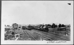
Otiria is the northernmost operational point of the national railway network. It is the terminus of the North Auckland Line, although a disused siding extends into Moerewa. Otiria railway station (closed in 1993) was a railway junction until the mid-1980s. The Opua Branch section of the North Auckland Line ran northeast to Kawakawa and Opua, while the Okaihau Branch ran northwest to Kaikohe and Okaihau. The railway through Otiria was built in the early 20th century to connect Opua and Kawakawa with Whangarei; the through route opened on 13 April 1911. [4] This was quickly followed by the commencement of work on the Okaihau Branch from Otiria; it opened to Kaikohe in May 1914 and Okaihau in October 1923. [5]

In December 1925, passenger trains offering direct service to and from Auckland began running through Otiria. This was initially the Northland Express between Auckland and Opua, with carriages for Okaihau detached in Otiria. It was cancelled in November 1956 and replaced by 88 seater railcars that ran between Auckland and Okaihau. Due to declining patronage and the poor reliability of the railcars, this service ended in July 1967. [6] Mixed trains to Whangarei continued to operate; the final passenger service through Otiria ran on 18 June 1976. [7] The line from Otiria to Opua ceased to be used in 1985, and when the Okaihau Branch closed on 1 November 1987, Otiria became the northernmost locality served by rail in New Zealand. [8] In 2007, one freight train was timetabled to operate every weekday each way between Otiria and Whangarei. [9] However the line was mothballed in August 2016. As of March, 2019, a possible re-opening of all or part of the Whangarei to Otiria line for freight only is under consideration. [10] In January 2020 the Government announced the reopening and building of a container terminal as part of a $109.7 million investment in Northland rail. [11]

Related Research Articles

Kaikohe Place in Northland Region, New Zealand

Kaikohe is a town in the Far North District of New Zealand, situated on State Highway 12 about 260 km from Auckland. It is the largest inland town and highest community above sea level in the Northland Region. With a population of over 4000 people it is a shopping and service centre for an extensive farming district and is sometimes referred to as "the hub of the north".

Far North District Territorial authority in Northland Region, New Zealand

The Far North District is the northernmost territorial authority district of New Zealand, consisting of the northern part of the Northland Peninsula in the North Island. It stretches from North Cape and Cape Reinga / Te Rerenga Wairua in the north, down to the Bay of Islands, the Hokianga and the town of Kaikohe.

Kawakawa, New Zealand Place in Northland Region, New Zealand

Kawakawa is a small town in the Bay of Islands area of the Northland Region of New Zealand. Kawakawa developed as a service town when coal was found there in the 1860s, but coal mining ceased in the early 20th century. The economy is now based on farming. The town is named after the kawakawa shrub.

Moerewa Place in Northland Region, New Zealand

Moerewa is a small town in the Northland Region of the North Island of New Zealand. It is located close to the Bay of Islands five kilometres to the west of Kawakawa.

The Dargaville Branch is a branch line railway that leaves the North Auckland Line not far south of Whangarei and runs westward to Dargaville. Construction of this relatively short line took approximately two decades, and when it was completed, it linked the now closed Donnelly's Crossing Section with the national rail network. The branch has been closed to all traffic since 2014 and is currently used by a tourist railcart operation.

North Auckland Line railway line in New Zealand

The North Auckland Line is a major section of New Zealand's national rail network, and is made up of the following parts: the portion of track that runs northward from Westfield Junction to Newmarket Station; from there, westward to Waitakere; from there, northward to Otiria via Whangārei. The first section was opened in 1868 and the line was completed in 1925. The line, or sections of it, have been known at various times as the Kaipara Line, the Waikato-Kaipara Line, the Kaipara Branch and the North Auckland Main Trunk.

The Okaihau Branch, sometimes known as the Kaikohe Branch and rarely the Rangiahua Branch, was a branch line railway that joined the North Auckland Line of the national rail network of New Zealand at Otiria. It was the most northerly line in New Zealand and was intended to run all the way to Kaitaia. It opened to Ōkaihau in 1923 and closed in 1987.

The Onerahi Branch, sometimes known as the Grahamstown Railway, was a branch line railway in the Northland Region of New Zealand. It operated from 1911 until 1933 and linked the city of Whangārei to the nearby harbour in Onerahi.

The Opua Branch or Otiria-Opua Industrial Line, partially still operational as the Bay of Islands Vintage Railway, is a former section of the North Auckland Line in the Northland Region of New Zealand, between Otiria and the Bay of Islands township of Opua. The first section was constructed as a bush tramway in 1868 and converted to a railway in the next decade. Today the railway is partially used by the Bay of Islands Vintage Railway, which runs tourist services between Kawakawa and Taumarere. The line's centrepiece is the section where it runs down along the main street of Kawakawa.

NZR RM class (88 seater) class of 35 New Zealand railcars

The NZR RM class 88-seaters were a class of railcar used in New Zealand. New Zealand Government Railways (NZR) classed them RM , the notation used for all railcars, numbering the 35 sets from RM100 to RM134. They were the most numerous railcars in NZR service, and were known unofficially as "Articulated", "Eighty Eights", "Twinsets", "Drewrys" or "Fiats". Their purchase and introduction saw the demise of steam-hauled provincial passenger trains and mixed trains.

Glossary of New Zealand railway terms Wikipedia glossary

This is a list of jargon commonly used by railfans and railway employees in New Zealand.

The Northland Express, also known as the Opua Express, was an express passenger train operated by the New Zealand Railways Department between 1925 and 1956. It ran from Auckland via Whangarei to Opua in the Bay of Islands.

Opua Place in Northland Region, New Zealand

Opua is a locality in the Bay of Islands, in the sub-tropical Northland Region of New Zealand. It is notable as the first port for overseas yachts arriving in the country after crossing the Pacific Ocean. In the original 1870s plans for the town, it was named Newport. The town of Paihia is nearby, and the small settlement of Te Haumi is in between.

Ōkaihau Place in Northland Region, New Zealand

Ōkaihau is a small town in the Northland Region of New Zealand's North Island, just north of Kaikohe. State Highway 1 passes through Okaihau making it fairly busy. Okaihau has a primary school and a secondary school.

The Marsden Point Branch is a proposed branch line railway in the Northland Region of New Zealand's North Island. It would diverge from the North Auckland Line south of Whangarei and serve Northport at Marsden Point. The proposal has existed since the 1970s and as of 2007, land is actively being purchased for a rail corridor. In October 2017, the new Labour–NZ First coalition government announced that it would spend $600 million on rehabilitating the North Auckland Line and building the branch at a cost of $200 million, the total works to cost $800 million.

The Wanganui Branch is a 5.00 km branch line railway in the Manawatu-Wanganui region of New Zealand's North Island. It links Wanganui with the Marton - New Plymouth Line (MNPL) at Aramoho and has been open since 21 January 1878, although solely for freight traffic since 7 September 1959. Another branch line diverged from the Wanganui Branch near its terminus, the Castlecliff Branch.

Taumarere Place in Northland Region, New Zealand

Taumarere is a locality in the Bay of Islands in Northland, New Zealand. The Kawakawa River and State Highway 11 run through Taumarere. The town of Kawakawa is 3 km to the southwest. Opua is 7 km to the north and Paihia 14 km.

Bay of Islands Vintage Railway

The Bay of Islands Vintage Railway Trust (BOIVRT) is a heritage railway in Kawakawa, in Northland in New Zealand. The railway operates on part of the former Opua Branch railway.

Kawakawa River river in New Zealand

The Kawakawa River is in the Northland Region of New Zealand's North Island. It flows predominantly eastward to Opua, where it joins the Waikare Inlet to flow into the Veronica Channel at the southern end of the Bay of Islands.

Kaikohe Aerodrome airport in New Zealand

Kaikohe Aerodrome is an airfield south-east of Kaikohe in the Northland region of New Zealand. Built in 1942 as a US Marines bomber base, is the largest grass strip in the Southern hemisphere used now by general aviation. Other than powered aircraft, gliders use the airfield, and an area next to the runways is used by model airplane flyers. There are skydiving operations as well, with a landing spot near the old terminal.

References

  1. "Place name detail: Otiria". New Zealand Gazetteer. Land Information New Zealand . Retrieved 27 June 2008.
  2. "1000 Māori place names". New Zealand Ministry for Culture and Heritage. 6 August 2019.
  3. "Mergers, Closures and New Schools, January 2005 - December 2005" (XLS). Education Counts.
  4. H. J. Hansen and F. J. Neil, Tracks in the North (Auckland: H. J. Hansen, 1992), 86-88.
  5. David Leitch and Brian Scott, Exploring New Zealand's Ghost Railways, revised edition (Wellington: Grantham House, 1998 [1995]), 9.
  6. J. D. Mahoney, Kings of the Iron Road: Steam Passenger Trains of New Zealand (Palmerston North: Dunmore Press, 1982), 13.
  7. Churchman & Hurst 2001, p. 96.
  8. Churchman & Hurst 2001, p. 95.
  9. [http://www.railnz.co.nz/times/TrainTimetableGuide.htm New Zealand Train Timetable Guide Archived 2007-10-10 at the Wayback Machine , effective 17 June 2007, last updated 21 June 2007, accessed 27 June 2008.
  10. 'Northland rail line may reopen' The Northern Advocate, March 28, 2019
  11. "Northland rail rejuvenation". KiwiRail. Retrieved 2020-01-31.

Bibliography

  • Churchman, Geoffrey B; Hurst, Tony (2001) [1990, 1991]. The Railways of New Zealand: A Journey through History (Second ed.). Transpress New Zealand. ISBN   0-908876-20-3.

Coordinates: 35°23′54″S174°00′01″E / 35.39833°S 174.00028°E / -35.39833; 174.00028