Coca-Cola, or Coke, is a carbonated soft drink manufactured by The Coca-Cola Company. Originally marketed as a temperance drink and intended as a patent medicine, it was invented in the late 19th century by John Stith Pemberton and was bought out by businessman Asa Griggs Candler, whose marketing tactics led Coca-Cola to its dominance of the world soft-drink market throughout the 20th century. The drink's name refers to two of its original ingredients: coca leaves, and kola nuts. The current formula of Coca-Cola remains a trade secret; however, a variety of reported recipes and experimental recreations have been published. The drink has inspired imitators and created a whole classification of soft drink: colas.

The Northland Region is the northernmost of New Zealand's 16 local government regions. New Zealanders sometimes refer to it as the Winterless North because of its mild climate. The main population centre is the city of Whangārei, and the largest town is Kerikeri. At the 2018 New Zealand census Northland recorded a surprising population growth spurt of 18.1% since the previous 2013 census, placing it as the fastest growing region of New Zealand, ahead of other strong growth regions such as the Bay of Plenty and Waikato.
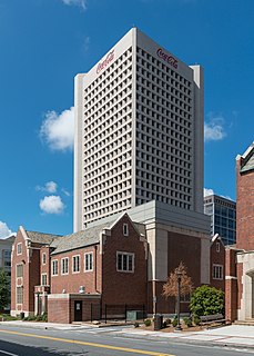
The Coca-Cola Company is an American multinational beverage corporation incorporated under Delaware's General Corporation Law and headquartered in Atlanta, Georgia. The Coca-Cola Company has interests in the manufacturing, retailing, and marketing of nonalcoholic beverage concentrates and syrups. The company produces Coca-Cola, invented in 1886 by pharmacist John Stith Pemberton. In 1889, the formula and brand were sold for $2,300 to Asa Griggs Candler, who incorporated The Coca-Cola Company in Atlanta in 1892.
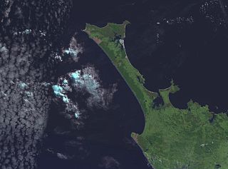
The Aupouri Peninsula is a tombolo at the northern tip of the North Island of New Zealand. It projects between the Tasman Sea to the west and the Pacific Ocean to the east. It constitutes the northern part of the Far North District, incorporating North Cape, Houhora and the northern half of Awanui.

Lake Ōmāpere is the largest lake in the Northland Region of New Zealand. It is located to the North of Kaikohe.
Kofi Karikari was the tenth King of the Kingdom of Ashanti, and grandnephew of Kwaku Dua I, whose sudden death in April 1867 sparked internal strife about the succession. Kofi Karikari was chosen by electoral majority, reigning from 28 May 1867 until his forced abdication on 26 October 1874. Karikari was the son of Afua Kobi.
The Karikari Peninsula on the east coast of the far north of Northland is between Rangaunu Harbour to the west, and Doubtless Bay to the southeast. It is a right-angled land mass of two relatively distinct parts. The rocky northern part, which has an east–west orientation and is approximately 17 km long, was originally an island but is now connected to the mainland by a low sandy tombolo approximately 11 km long, which has a north–south orientation. The spiritually significant Puwheke sits high above the north-facing beaches.

Godfred Karikari is a Ghanaian-born Hong Kong former professional footballer.
Bulrush Lake is a small lake on the Aupouri Peninsula in the Northland Region of New Zealand. It has a wetland area at its southwest end, but no flow outlet. On the north side of the lake there is an inflow drain. The catchment is predominately pine forest and pasture, with a small amount scrub to the west.
Half Mile Lagoon is a lake in the Northland Region of New Zealand. It is located 5 km to the northwest of Ngataki, on the Aupouri Peninsula.
Lake Morehurehu is a dune lake in the Northland Region of New Zealand. It is located to the Northeast of Te Kao on the Aupouri Peninsula.
Lake Ngakapua is a dune lake in the Northland Region of New Zealand. It is located to the northwest of Awanui, near Waipapakauri on the Aupouri Peninsula.
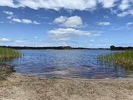
Lake Waiparera is a dune lake in the Northland Region of New Zealand.It is located immediately North-West of Waiharara on the Aupouri Peninsula. The lake is the largest of the Aupouri Lakes. The catchment is predominately pasture, with the remainder scrub or wetland. The lake has several inflows (drains), with no obvious outflows. The lake is easily accessed from SH1.
Lake Waiporohita is a dune lake in the Northland Region of New Zealand. It is located near Tokerau Beach on the Karikari Peninsula.

New Zealand's Northland Region is built upon a basement consisting mainly of greywacke rocks, which are exposed on the eastern side of the peninsula. In-place Eocene coal measures crop out at Kamo, near Whangarei, and Oligocene limestone crops out at Hikurangi, near Whangarei.
Rangaunu Harbour is a shallow harbour in the far north of New Zealand. It is situated on the east coast at the base of the Aupouri Peninsula. The name in Māori means "To pull out a shoal of fish". With an area of 115 square kilometres (44 sq mi) it is the fifth-largest harbour in New Zealand.
Muriwhenua are a group of northern Māori iwi, based in Te Hiku o te Ika, the northernmost part of New Zealand's North Island. It consists of five iwi, Ngāti Kurī, Ngāi Takoto, Te Pātū, Ngāti Kahu, Te Aupōuri and Te Rarawa, with a combined population of about 34,000 people. The spiritually significant Hokianga Harbour, located just to the south of the Maungataniwha Range, is of special significance to the Muriwhenua people.
Clitarchus tepaki is a stick insect that belongs to the common New Zealand genus Clitarchus. It is endemic to the North Cape area of New Zealand, in particular Te Paki and the Karikari Peninsula.
Lake Rotokawau is the name of numerous lakes in New Zealand:
Lake Rotokawau is a dune lake on the Karikari Peninsula in the Far North District of New Zealand. It is northeast of Rangiputa village and near Puwheke Beach. It is sometimes referred to as 'Lake Rotokawau West' and is the larger of two adjacent lakes.