The North Island, also officially named Te Ika-a-Māui, is one of the two main islands of New Zealand, separated from the larger but much less populous South Island by the Cook Strait. The island's area is 113,729 square kilometres (43,911 sq mi), making it the world's 14th-largest island. It has a population of 3,896,200, accounting for approximately 77% of the total residents of New Zealand.

The South Island, also officially named Te Waipounamu, is the larger of the two major islands of New Zealand in surface area, the other being the smaller but more populous North Island. It is bordered to the north by Cook Strait, to the west by the Tasman Sea, and to the south and east by the Pacific Ocean. The South Island covers 150,437 square kilometres (58,084 sq mi), making it the world's 12th-largest island. At low altitude, it has an oceanic climate.

Queenstown is a resort town in Otago in the south-west of New Zealand's South Island. It has an urban population of 16,000.

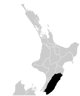
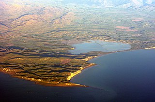
Wairarapa, a geographical region of New Zealand, lies in the south-eastern corner of the North Island, east of metropolitan Wellington and south-west of the Hawke's Bay Region. It is lightly populated, having several rural service towns, with Masterton being the largest. It is named after its largest lake, Lake Wairarapa.

Rotorua is a city on the southern shores of Lake Rotorua from which the city takes its name, in the Bay of Plenty region of New Zealand's North Island. It is the seat of the Rotorua Lakes District, a territorial authority encompassing Rotorua and several other nearby towns. Rotorua has an estimated resident population of 58,500, making it the country's 12th largest urban area, and the Bay of Plenty's second largest urban area behind Tauranga.

Chatham Island is by far the largest island of the Chatham Islands group, in the south Pacific Ocean off the eastern coast of New Zealand's South Island. It is said to be "halfway between the equator and the pole, and right on the International Date Line", though the point in fact lies ca. 173 miles WSW of the island's westernmost point. The island is called Rekohu in Moriori, and Wharekauri in Māori.

Fiordland National Park occupies the southwest corner of the South Island of New Zealand. It is by far the largest of the 13 national parks in New Zealand, with an area of 12,607 square kilometres (4,868 sq mi), and a major part of the Te Wahipounamu World Heritage site. The park is administered by the Department of Conservation.

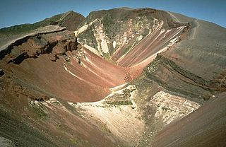
Mount Tarawera is a volcano on the North Island of New Zealand. Located 24 kilometres southeast of Rotorua, it consists of a series of rhyolitic lava domes that were fissured down the middle by an explosive basaltic eruption in 1886. This eruption was one of New Zealand's largest historical eruptions, and killed an estimated 120 people. The fissures run for about 17 kilometres northeast-southwest.

Wanaka, called Pembroke by post-colonial inhabitants until 1940, is a popular ski and summer resort town in the Otago region of the South Island of New Zealand. At the southern end of Lake Wānaka, it is at the start of the Clutha River / Mata-Au and is the gateway to Mount Aspiring National Park.

Nelson Lakes National Park is in the South Island of New Zealand, at the northern end of the Southern Alps. It was formed after the passing of the National Parks Act in 1952. It was created in 1956. The park contains beech forests, multiple lakes, snow covered mountains and valleys created by glaciers during the ice ages.

Bevan John Docherty is a triathlete from New Zealand, who won medals twice at the Olympic Games. Docherty attended Tauhara College, Taupo.

Lake Pukaki is the largest of three roughly parallel alpine lakes running north–south along the northern edge of the Mackenzie Basin on New Zealand's South Island. The others are Lakes Tekapo and Ohau. All three lakes were formed when the terminal moraines of receding glaciers blocked their respective valleys, forming moraine-dammed lakes. The Alps2Ocean mountain bike trail follows the edge of Lake Pukaki for part of its length.

Lake Grassmere / Kapara Te Hau is a New Zealand lake in the northeastern South Island, close to Cook Strait. The lake is used for the production of salt.

Lake Waikaremoana is located in Te Urewera in the North Island of New Zealand, 60 kilometres northwest of Wairoa and 80 kilometres west-southwest of Gisborne. It covers an area of 54 km2 (21 sq mi). From the Maori Waikaremoana translates as 'sea of rippling waters'.

Saint Arnaud is a small alpine village in the Tasman district of New Zealand's South Island, west of the mountains of the Saint Arnaud Range and 90 kilometres southwest of Nelson near the historic Tophouse Settlement. It is situated at the northern end of Lake Rotoiti.
Kelvin David George Nagle AM was an Australian professional golfer best known for winning The Open Championship in 1960. He won at least one tournament each year from 1949 to 1975.
Ashburton was a New Zealand electorate, first created in 1881 and centred on the South Island town of Ashburton.

New Zealand is an island country in the southwestern Pacific Ocean. It consists of two main landmasses—the North Island and the South Island —and more than 700 smaller islands, covering a total area of 268,021 square kilometres (103,500 sq mi). New Zealand is about 2,000 kilometres (1,200 mi) east of Australia across the Tasman Sea and 1,000 kilometres (600 mi) south of the islands of New Caledonia, Fiji, and Tonga. The country's varied topography and sharp mountain peaks, including the Southern Alps, owe much to tectonic uplift and volcanic eruptions. New Zealand's capital city is Wellington, and its most populous city is Auckland.

State Highway 6 is a major New Zealand state highway. It extends from the northeastern corner of the South Island across the top of the island, then down the length of the island, initially along the West Coast and then across the Southern Alps through inland Otago and finally across the Southland Plains to the island's south coast. Distances are measured from north to south.
Jake Robertson is a New Zealand distance runner. When he was 17 he moved to Iten, Kenya with his twin brother and fellow professional runner Zane Robertson.


