
RNZ National, formerly Radio New Zealand National, and known until 2007 as the National Programme or National Radio, is a publicly funded non-commercial New Zealand English-language radio network operated by Radio New Zealand. It specialises in programmes dedicated to news, the arts, music, and New Zealand culture generally, including some material in the Māori language. Historically the programme was broadcast on the (AM) "YA" stations 1YA, 2YA, 3YA and 4YA in the main centres.

The Horeke basalts is a disused formation that contained Miocene-Pliocene basalt lava flows that covered a large area in central Northland Region of New Zealand, and in places forms a high plateau around Okaihau.
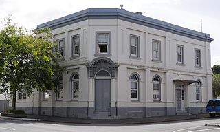
Kaikohe is the seat of the Far North District of New Zealand, situated on State Highway 12 about 260 km from Auckland. It is the largest inland town and highest community above sea level in the Northland Region. With a population of over 4000 people it is a shopping and service centre for an extensive farming district and is sometimes referred to as "the hub of the north".

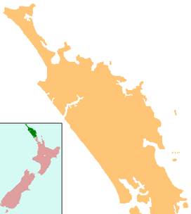
The Far North District is the northernmost territorial authority district of New Zealand, consisting of the northern part of the Northland Peninsula in the North Island. It stretches from North Cape and Cape Reinga / Te Rerenga Wairua in the north, down to the Bay of Islands, the Hokianga and the town of Kaikohe.

The Okaihau Branch, sometimes known as the Kaikohe Branch and rarely the Rangiahua Branch, was a branch line railway that joined the North Auckland Line of the national rail network of New Zealand at Otiria. It was the most northerly line in New Zealand and was intended to run all the way to Kaitaia. It opened to Ōkaihau in 1923 and closed in 1987.
Florian Habicht is a New Zealand film director. Florian was born in Berlin, Germany and moved with his family to the Bay of Islands, New Zealand, when he was eight. He went to high school in Kerikeri before attending the University of Auckland's Elam School of Fine Arts.
Monument Hill may refer to:
The Ngawha geothermal field is a geothermal area in the North Island of New Zealand. It is situated approximately 5 km east of Kaikohe and is centred on the village of Ngawha Springs. The field covers an area of around 25 km2, much smaller than the other major high-temperature geothermal field in New Zealand, the Taupo Volcanic Zone. The hot springs arising in this area are slightly acidic and are rich in ammonia, bicarbonate, boron and mercury, which is not typical of springs in New Zealand.
Radio Northland was a radio station based in Whangarei, New Zealand.
Far North District Council is the territorial authority for the Far North District of New Zealand.
Far North is a former New Zealand parliamentary electorate, which existed for one parliamentary term from 1993 to 1996, and was held by National's John Carter.
Otiria is a rural locality in the Northland Region of New Zealand's North Island. It neighbours Moerewa to the east, with the nearest major town, Kawakawa a few kilometres further eastwards. Other nearby localities include Pokapu to the south, Orauta to the west, and Hupara to the north.

The recently active basaltic Kaikohe-Bay of Islands volcanic field in the Northland Region of New Zealand is associated geographically with an older region of extinct volcanism to its north the Wairakau Volcanic Centre, meaning eruptions in this region have occurred over the last 20 million years. All the cones older than 2 million years have eroded away, leaving plateaus from Ōkaihau to Kerikeri and north to Whangaroa from the old andesite/dacite stratovolcanoes of the Wairakau Volcanic Centre and the ten million year old or more recent volcanoes in field towards the south. In the southern part of the field, around 12 small basaltic scoria cones, and a rhyolite dome erupted in the last 500,000 years around Kaikohe. The field is considered dormant, rather than extinct.
Te Puke is a 136 metres (446 ft) high group of basaltic scoria cones, in the Kaikohe-Bay of Islands volcanic field in Northland, New Zealand. It is the easternmost volcano of the field, being located near Waitangi. The three or four small, cratered cones are in a southwest–northeast alignment. The last eruption was 1300 to 1800 years ago.
Maungaturoto is a 282 metres (925 ft) high basaltic scoria cone, in the Kaikohe-Bay of Islands volcanic field in New Zealand. It was the site of a pā.
Tarahi is a 388 m (1,273 ft) high andesite volcano, in the Kaikohe-Bay of Islands volcanic field in New Zealand. Northwest of Tarahi is a smaller, 350 m (1,150 ft) basaltic scoria cone, Haruru pā, before the higher cone of Te Ahuahu. To its immediate east is Putahi and the location of a famous battle of the Flagstaff War adjacent to Lake Ōmāpere.
Kaikohe Aerodrome is an airfield south-east of Kaikohe in the Northland region of New Zealand. Built in 1942 as a US Marines bomber base, is the largest grass strip in the Southern hemisphere used now by general aviation. Other than powered aircraft, gliders use the airfield, and an area next to the runways is used by model airplane flyers. There are skydiving operations as well, with a landing spot near the old terminal.

Peter Smith was a New Zealand rugby union player. He was a member of the 1947 All Blacks team that toured Australia, but did not appear in any Test matches. He played second five-eighth.
The 2004 New Year Honours in New Zealand were appointments by Elizabeth II in her right as Queen of New Zealand, on the advice of the New Zealand government, to various orders and honours to reward and highlight good works by New Zealanders, and to celebrate the passing of 2003 and the beginning of 2004. They were announced on 31 December 2003.
