The Ring of Fire is a tectonic belt of volcanoes and earthquake.
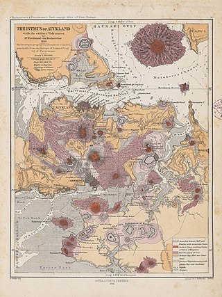
The Auckland volcanic field is an area of monogenetic volcanoes covered by much of the metropolitan area of Auckland, New Zealand's largest city, located in the North Island. The approximately 53 volcanoes in the field have produced a diverse array of maars, tuff rings, scoria cones, and lava flows. With the exception of Rangitoto, no volcano has erupted more than once, but the other eruptions lasted for various periods ranging from a few weeks to several years. Rangitoto erupted several times and recently twice; in an eruption that occurred about 600 years ago, followed by a second eruption approximately 50 years later. The field is fuelled entirely by basaltic magma, unlike the explosive subduction-driven volcanism in the central North Island, such as at Mount Ruapehu and Lake Taupō.

The Anahim Volcanic Belt (AVB) is a west–east trending chain of volcanoes and related magmatic features in British Columbia, Canada. It extends from Athlone Island on the Central Coast, running eastward through the strongly uplifted and deeply dissected Coast Mountains to near the community of Nazko on the Interior Plateau. The AVB is delineated as three west-to-east segments that differ in age and structure. A wide variety of igneous rocks with differing compositions occur throughout these segments, comprising landforms such as volcanic cones, volcanic plugs, lava domes, shield volcanoes and intrusions.

Volcanic activity is a major part of the geology of Canada and is characterized by many types of volcanic landform, including lava flows, volcanic plateaus, lava domes, cinder cones, stratovolcanoes, shield volcanoes, submarine volcanoes, calderas, diatremes, and maars, along with less common volcanic forms such as tuyas and subglacial mounds.

The geology of the Pacific Northwest includes the composition, structure, physical properties and the processes that shape the Pacific Northwest region of North America. The region is part of the Ring of Fire: the subduction of the Pacific and Farallon Plates under the North American Plate is responsible for many of the area's scenic features as well as some of its hazards, such as volcanoes, earthquakes, and landslides.

Mount Manaia is a dominant landmark approximately 30 kilometres southeast of Whangārei city on the Whangārei Heads peninsula.
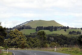
Hurupaki Mountain is in Kamo, Whangārei, New Zealand. The centre of Hurupaki Mountain lies between Three Mile Bush Road and Dip Road, approximately 1.5 kilometres west of Kamo township. Hurupaki Mountain is visible from State Highway 1.

The volcanism of New Zealand has been responsible for many of the country's geographical features, especially in the North Island and the country's outlying islands.

The geology of New Zealand is noted for its volcanic activity, earthquakes and geothermal areas because of its position on the boundary of the Australian Plate and Pacific Plates. New Zealand is part of Zealandia, a microcontinent nearly half the size of Australia that broke away from the Gondwanan supercontinent about 83 million years ago. New Zealand's early separation from other landmasses and subsequent evolution have created a unique fossil record and modern ecology.

The Auckland Region of New Zealand is built on a basement of greywacke rocks that form many of the islands in the Hauraki Gulf, the Hunua Ranges, and land south of Port Waikato. The Waitākere Ranges in the west are the remains of a large andesitic volcano, and Great Barrier Island was formed by the northern end of the Coromandel Volcanic Zone. The Auckland isthmus and North Shore are composed of Waitemata sandstone and mudstone, and portions of the Northland Allochthon extend as far south as Albany. Little Barrier Island was formed by a relatively isolated andesitic volcano, active around 1 to 3 million years ago.

The Canadian Cascade Arc, also called the Canadian Cascades, is the Canadian segment of the North American Cascade Volcanic Arc. Located entirely within the Canadian province of British Columbia, it extends from the Cascade Mountains in the south to the Coast Mountains in the north. Specifically, the southern end of the Canadian Cascades begin at the Canada–United States border. However, the specific boundaries of the northern end are not precisely known and the geology in this part of the volcanic arc is poorly understood. It is widely accepted by geologists that the Canadian Cascade Arc extends through the Pacific Ranges of the Coast Mountains. However, others have expressed concern that the volcanic arc possibly extends further north into the Kitimat Ranges, another subdivision of the Coast Mountains, and even as far north as Haida Gwaii.

New Zealand's Northland Region is built upon a basement consisting mainly of greywacke rocks, which are exposed on the eastern side of the peninsula. In-place Eocene coal measures crop out at Kamo, near Whangarei, and Oligocene limestone crops out at Hikurangi, near Whangarei.
Te Puke is a 136 metres (446 ft) high group of basaltic scoria cones, in the Kaikohe-Bay of Islands volcanic field in Northland, New Zealand. It is the easternmost volcano of the field, being located near Waitangi. The three or four small, cratered cones are in a southwest–northeast alignment. The last eruption was 1300 to 1800 years ago.

Markagunt Plateau is a volcanic field in southern Utah, United States. Formed in a region of older volcanics, it consists of several cinder cones and associated lava flows. Some of the lava flows feature lava tubes such as Mammoth Cave, while others have formed lava dams and lakes like Navajo Lake. Volcanism took place during the Pliocene and latest Pleistocene but may have continued into the Holocene; legends of the Southern Paiute may reflect past eruptions.
The Waitākere volcano, also known as the Manukau volcano, was a Miocene era volcano that formed off the west coast of the modern Auckland Region of New Zealand's North Island. Erupting intermittently between 23 million and 15 million years ago, the volcano was at one point one of the tallest mountains in New Zealand. The volcano alternated between periods as a seamount and as a volcanic island, before tectonic forces raised the volcano up from the seafloor 17 million years ago. Volcanism at the site ceased 15 million years ago and the cone has mostly eroded, however the modern Waitākere Ranges are formed from the remnants of the volcano's eastern slopes. A number of visible volcanic sites associated with the Waitākere volcano remain around Auckland, including Pukematekeo, Karekare and Lion Rock.

The South Auckland volcanic field, also known as the Franklin Volcanic Field, is an area of extinct monogenetic volcanoes around Pukekohe, the Franklin area and north-western Waikato, south of the Auckland volcanic field. The field contains at least 82 volcanoes, which erupted between 550,000 and 1,600,000 years ago.
The extinct Ngatutura volcanic field that was active between 1.54 and 1.83 million years ago is one of four volcanic fields in an intraplate back arc relationship with the still active Hauraki Rift and the presently dormant Auckland volcanic field. The other volcanic fields, which are part of the Auckland Volcanic Province, are the oldest, Okete to the south near Raglan in late Pliocene times. and to the north the younger South Auckland volcanic field.
The Alexandra Volcanic Group is a chain of extinct calc-alkalic basaltic stratovolcanoes that were most active between 2.74 and 1.60 million years ago but is now known to have had more recent activity between 1.6 and 0.9 million years ago. They extend inland from Mount Karioi near Raglan with Mount Pirongia being the largest, with Pukehoua on the eastern slopes of Pirongia, Kakepuku, Te Kawa, and Tokanui completing the definitive lineament. The associated, but usually separated geologically basaltic monogenetic Okete volcanic field, lies mainly between Karioi and Pirongia but extends to the east and is quite scattered.
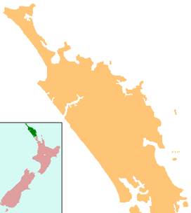
The Whangārei volcanic field is an area of intra-plate monogenetic volcanism located near the city of Whangārei, North Island, New Zealand. It was last active between 260,000 to 319,000 years ago and continues to be potentially active as a low-velocity seismic zone in the crust exists beneath Whangārei, which is interpreted to be a body of partial melt. This mantle source has been coupled to the lithosphere for about 8 million years. As the field has potentially been active at low frequency for millions of years, with 100,000 years or more between events it might best be regarded as dormant. The recent vents active in the last million years include some dacite in composition. Composition details are freely available for most of the field but many vents do not have ages.
Much of the volcanic activity in the northern portions of the North Island of New Zealand is recent in geological terms and has taken place over the last 30 million years. This is primarily due to the North Island's position on the boundary between the Indo-Australian and Pacific Plates, a part of the Pacific Ring of Fire, and particularly the subduction of the Pacific Plate under the Indo-Australian Plate. The activity has included some of the world's largest eruptions in geologically recent times and has resulted in much of the surface formations of the North Island being volcanic as shown in the map.