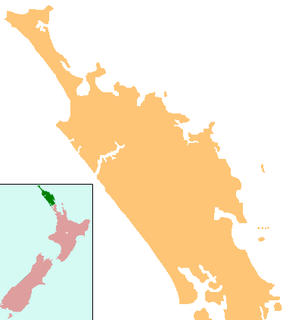
Towai or Tōwai is a locality in the Northland Region of the North Island of New Zealand. State Highway 1 passes just to the east. Kawakawa is 16 km northwest, and Whakapara is 17 km southeast.

Rahotu is a community in the west of Taranaki, in the North Island of New Zealand. It is located on State Highway 45, 16 kilometres north of Opunake and 11 km south of Warea.

Kaniere is a locality in the Westland District of the West Coast region of New Zealand's South Island. Hokitika lies to the north-west, and the Hokitika River flows past to the south-west.

Barrytown is a town in the West Coast region of New Zealand's South Island. Barrytown sits on State Highway 6 and is 21 kilometres (13 mi) north of Runanga. Punakaiki is 16 kilometres (10 mi) further north. The town is near the southern end of Pakiroa Beach.

Waiharara is a community at the base of the Aupouri Peninsula in Northland, New Zealand. State Highway 1 runs through the community. To the west is Aupouri Forest, and beyond that Ninety Mile Beach. To the east is Rangaunu Harbour. Houhora is 22 km north west, and Awanui is 16 km south east. Lake Waiparera, 35 metres above sea level, is immediately to the north west.

Motatau or Mōtatau is a locality in the Northland Region of the North Island of New Zealand. Maromaku is to the east. The Taikirau Stream flows from east through Motatau and then runs northwest to join the Waiharakeke Stream.

Hukerenui is a settlement in Northland, New Zealand. State Highway 1 passes through the area. Kawakawa is northwest, and Hikurangi is southeast.

Purua is a locality north west of Whangarei in Northland, New Zealand. A hill also called Purua with a summit 387 m above sea level lies to the east. The area mainly consists of rolling hills and river flats. Farming is Dairy, Sheep and Beef. The local hall is one of the notable buildings.

Waiotira is a locality in Northland, New Zealand. Whangarei is to the northeast. Tauraroa is about 9 km northeast. The North Auckland railway line passes through Tauraroa, and the Waiotira Stream flows southwest to join with the Omaru River.

Whananaki is a locality on the east coast of Northland, New Zealand. Whangarei is to the southwest. Te Wairahi Stream flows from the northwest into Whananaki Inlet, a wide tidal estuary which separates Whananaki from Whananaki South. Sandy Bay lies to the southeast. A long wooden footbridge connects Whananaki North and Whananaki South, with an alternative connection being a 6-kilometre-long (3.7 mi) road that crosses the river above the estuary. Hikurangi is about 22 km southwest of Whananaki South.

Makahu is a settlement in inland Taranaki, in the western North Island of New Zealand. It is located to the southeast of Strathmore. the Makahu Stream runs south through the area to join with the Mangaehu Stream, which flows into the Patea River.

Pembroke is a settlement in inland Taranaki, in the western North Island of New Zealand. It is located about 5 km northwest of Stratford.

Kakaramea is a town in South Taranaki, New Zealand. State Highway 3 passes through it. Patea is about 6 km to the south-east, and Hawera is about 20 km to the north-west.

Matapu is a locality in southern Taranaki Region of New Zealand. Hawera is to the south-east, Eltham to the north-east, Kaponga to the north-west and Manaia to the south-west.

Mimi is a locality in northern Taranaki, in the North Island of New Zealand. It is located on State Highway 3 close to the shore of the North Taranaki Bight, 6 kilometres north-east of Urenui and 26 km south-west of Ahititi. The Mimi River flows past the settlement into the North Taranaki Bight.

Norfolk is a locality in Taranaki, in the North Island of New Zealand. It is located on State Highway 3, about 5.5 kilometres south-east of Inglewood and 10.5 km north-west of Midhirst.

Maruia is a locality in the West Coast region of New Zealand. The Shenandoah Highway passes through it. Murchison is 65 km north, the Lewis Pass is 39 km to the south-east, and Reefton is 63 km west by road. The Maruia River flows past to the west.

Cobden is a suburb to the north of Greymouth on the West Coast of New Zealand. The Grey River separates Cobden from the rest of Greymouth. To the north is the Rapahoe Range, also called the Twelve Apostles Range. State Highway 6 skirts the south-eastern edge of Cobden.

Tomarata is a locality in the Rodney District of New Zealand. Wellsford lies to the south-west, Te Arai to the north, and Pakiri to the south-east. Tomarata Lake is nearby and is popular for boating, water skiing, kayaking and swimming.

Waitoki is a locality in the Rodney District of New Zealand. Wainui is approximately 5.5 kilometres to the north-east, Kaukapakapa 6.5 km to the north-west, and Dairy Flat 10 km to the south-east. The Wainui Stream joins the Waitoki Stream just to the north-east of the locality. The stream flows west into the Kaukapakapa River.


