A lagoon is a shallow body of water separated from a larger body of water by reefs, barrier islands, or a barrier peninsula. Lagoons are commonly divided into coastal lagoons and atoll lagoons. They have also been identified as occurring on mixed-sand and gravel coastlines. There is an overlap between bodies of water classified as coastal lagoons and bodies of water classified as estuaries. Lagoons are common coastal features around many parts of the world.

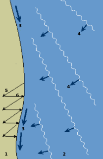
Longshore drift from longshore current is a geological process that consists of the transportation of sediments along a coast parallel to the shoreline, which is dependent on oblique incoming wave direction. Oblique incoming wind squeezes water along the coast, and so generates a water current which moves parallel to the coast. Longshore drift is simply the sediment moved by the longshore current. This current and sediment movement occur within the surf zone.

Chatham Island is by far the largest island of the Chatham Islands group, in the south Pacific Ocean off the eastern coast of New Zealand's South Island. It is said to be "halfway between the equator and the pole, and right on the International Date Line", though the point in fact lies ca. 173 miles WSW of the island's westernmost point. The island is called Rekohu in Moriori, and Wharekauri in Māori.

Manapouri is a small town in Southland / Fiordland, in the southwest corner of the South Island, in New Zealand. The township is the westernmost municipality in New Zealand. Located at the edge of the Fiordland National Park, on the eastern shore of Lake Manapouri, close to its outflow into the Waiau River, tourist boat services are based in the town.

Lake Ellesmere / Te Waihora is located in the Canterbury region of the South Island of New Zealand. It is actually a broad, shallow lagoon located directly to the west of Banks Peninsula, separated from the Pacific Ocean by a long narrow sandy spit called Kaitorete Spit, or more correctly Kaitorete Barrier. It lies partially in extreme southeastern Selwyn District and partially in the southwestern extension of the former Banks Peninsula District, which now is a ward in the city of Christchurch. The lake holds high historical and cultural significance to the indigenous Māori population and the traditional Māori name Te Waihora, means spreading waters. It has officially had a dual English/Māori name since at least 1938.

Ōkārito Lagoon is a coastal lagoon on the West Coast of New Zealand's South Island. It is located 130 kilometres (81 mi) south of Hokitika, and covers an area of about 3,240 hectares (12.5 sq mi), making it the largest unmodified coastal wetland in New Zealand. It preserves a sequence of vegetation types from mature rimu forest through mānuka scrub to brackish water that has been lost in much of the rest of the West Coast. Ōkārito Lagoon is the main feeding ground for New Zealand's only breeding population of rare white heron. The settlement of Ōkārito is at the southern end of the lagoon.

A glacial lake is a body of water with origins from glacier activity. They are formed when a glacier erodes the land, and then melts, filling the depression created by the glacier.

North Narrabeen is a suburb in northern Sydney, New South Wales, Australia 25 kilometres north of the Sydney central business district, in the local government area of Northern Beaches Council. North Narrabeen is part of the Northern Beaches region.

The New Zealand bittern is an extinct and enigmatic species of heron in the family Ardeidae. It was endemic to New Zealand and was last recorded alive in the 1890s.

Washdyke Lagoon is a brackish shallow coastal lagoon approximately 1 kilometre (0.62 mi) north of Timaru, South Canterbury, New Zealand. The lagoon has drastically reduced in size since 1881 when it was approximately 253 hectares, now it is less than 48 hectares (0.48 km2) in area. It is enclosed by a barrier beach that is 3 kilometres (1.9 mi) long and 3 metres (9.8 ft) above high tide at its largest point. The reduced lagoon size is due to the construction of the Timaru Port breakwater which is preventing coarse sediments from reaching and replenishing Washdyke Barrier. This is important as the lagoon and the surrounding 250 hectares are classified as a wildlife refuge and it demonstrates the role human structures have on coastline evolution.

The Waitahora Wind Farm was a proposed renewable energy project in New Zealand planned by Contact Energy but which has now been abandoned without construction beginning. This development was proposed to be located on the Puketoi Range which forms one side of the picturesque Waitahora Valley, near Dannevirke in Southern Hawke’s Bay.

Tomahawk Lagoon is a twin-lobed lagoon, located at the western end of the Otago Peninsula within the city limits of Dunedin, New Zealand. It lies close to the southeastern edge of the city's main urban area, near the suburb of Ocean Grove, which lies close to its southern shore. This suburb was also known as Tomahawk until the 1930s.

Half Mile Lagoon is a lake in the Northland Region of New Zealand. It is located 5 km to the northwest of Ngataki, on the Aupouri Peninsula.
Pukaki Lagoon, located in the suburb of Mangere, New Zealand, is one of the volcanoes in the Auckland volcanic field.

The Waituna Lagoon is on the southern coastline of the South Island of New Zealand. It forms part of the Awarua Wetland, a Ramsar site that was established in 1976.

The Avoca Lake, formerly known as Avoca Lagoon and as Bulbararing Lagoon, is an intermittently closed intermediate saline coastal lagoon that is located on the Central Coast region of New South Wales, Australia. Avoca Lake is located between the beachside settlements of North Avoca and Avoca Beach, and adjacent to the east coast, about 85 kilometres (53 mi) north of Sydney.

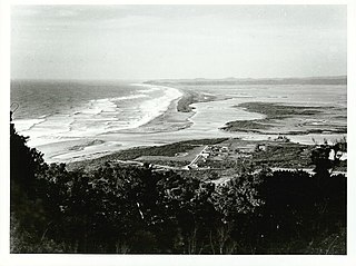
Ōkārito is a small coastal settlement on the West Coast of New Zealand's South Island, 127 kilometres (79 mi) southwest of Hokitika, and 10 kilometres (6.2 mi) from State Highway 6. It is built at the southern end of the Ōkārito Lagoon at the mouth of the Ōkārito River. The settlement of The Forks is located just inland, on the banks of the river.

A volcanic crater lake is a lake in a crater that was formed from explosive activity or collapse during a volcanic eruption.

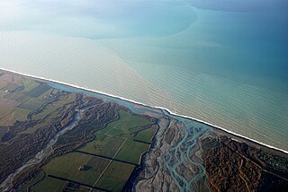
Hapua is the Māori term for river-mouth lagoons on mixed sand and gravel (MSG) beaches which form at the river-coast interface where a typically braided, although sometimes meandering, river interacts with a coastal environment that is significantly affected by longshore drift. The lagoons which form on the MSG coastlines are common on the east coast of the South Island of New Zealand and have long been referred to as hapua by the Māori. This classification differentiates hapua from similar lagoons located on the New Zealand coast termed waituna. Hapua are often located on paraglacial coastal areas where there is a low level of coastal development and minimal population density. Hapua form as the river carves out an elongated coast-parallel area, blocked from the sea by a MSG barrier which constantly alters its shape and volume due to longshore drift. Longshore drift continually extends the barrier behind which the hapua forms by transporting sediment along the coast. Hapua are defined as a narrow shore-parallel extensions of the coastal riverbed. They discharge the majority of stored water to the ocean via an ephemeral and highly mobile drainage channel or outlet. The remainder percolates through the MSG barrier due to its high levels of permeability. Hapua systems are driven by a wide range of dynamic processes that are generally classified as fluvial or marine; changes in the balance between these processes as well as the antecedent barrier conditions can cause shifts in the morphology of the hapua, in particular the barrier. New Zealand examples include the Rakaia, Ashburton and Hurunui river-mouths.


