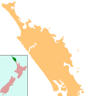
The Northland Region is the northernmost of New Zealand's 16 local government regions. New Zealanders sometimes refer to it as the Winterless North because of its mild climate. The main population centre is the city of Whangārei, and the largest town is Kerikeri. At the 2018 New Zealand census Northland recorded a surprising population growth spurt of 18.1% since the previous 2013 census, placing it as the fastest growing region of New Zealand, ahead of other strong growth regions such as the Bay of Plenty and Waikato.

The Aupouri Peninsula is a tombolo at the northern tip of the North Island of New Zealand. It projects between the Tasman Sea to the west and the Pacific Ocean to the east. It constitutes the northern part of the Far North District, incorporating North Cape, Houhora and the northern half of Awanui.

Lake Ōmāpere is the largest lake in the Northland Region of New Zealand. It is located to the North of Kaikohe.

The Awanui River is a river in the far north of New Zealand, close to the point at which the Aupouri Peninsula joins the rest of the Northland Peninsula. The Awanui flows first west and then north, for a total of 30 kilometres (19 mi), before flowing into Rangaunu Harbour. The town of Kaitaia is along its banks.

Lake Ngatu is a dune lake in the Northland Region of New Zealand. It is located to the northwest of Awanui, near Waipapakauri.

Lake Rotokawau is a dune lake on the Aupouri Peninsula the Far North, New Zealand. The name is also used for lakes in the Kaipara District, Chatham Islands, in Bay of Plenty and near Lake Waikare in Waikato.

Lake Rotoroa is a dune lake in the Northland Region of New Zealand. It is located to the west of Awanui.

Lake Taharoa is located in the Northland Region of New Zealand near Ripiro Beach. There is also a lake of the same name in the Waikato region.

Lake Te Kahika is a dune lake located on the Aupouri Peninsula in the Northland Region of New Zealand. It is one of the country's northernmost lakes.

Lake Waiparera is a dune lake in the Northland Region of New Zealand.It is located immediately North-West of Waiharara on the Aupouri Peninsula. The lake is the largest of the Aupouri Lakes. The catchment is predominately pasture, with the remainder scrub or wetland. The lake has several inflows (drains), with no obvious outflows. The lake is easily accessed from SH1.

Lake Waiporohita is a dune lake in the Northland Region of New Zealand. It is located near Tokerau Beach on the Karikari Peninsula.

Water pollution in New Zealand is an increasing concern for those who use and care for waterways and for New Zealand regulatory bodies. An increase in population is linked to an increase in water pollution, due to a range of causes such as rural land use, industrial use and urban development. Fresh water quality is under pressure from agriculture, hydropower, urban development, pest invasions and climate change. While pollution from point sources has been reduced, diffuse pollution such as nutrients, pathogens and sediments development and from stormwater in towns is not under control. There are more than 800 water quality monitoring sites around New Zealand that are regularly sampled.

Water is relatively abundant in New Zealand due to the temperate climate and maritime weather patterns. In recent years, water pollution and draw-down of aquifers have become important environmental issues in New Zealand.

Lake Harihari is a dune-dammed lake 10 km south of Kawhia in the Waikato region of New Zealand. Its water quality is the best amongst the Waikato dune lakes. It is ranked eighth in importance in the region. Its quality has been attributed to its remoteness.

The Awaroa River is a short river in the Waikato District of New Zealand's North Island. It flows east from its source in the dunes near Karioitahi Beach and Lake Puketi, then south from Waiuku joining with the Aka Aka Stream before reaching the Waikato River in its tidal reaches close to Motutieke Island.

The Mangatangi River, or Mangatangi Stream, originates on the eastern slopes of the Hunua Ranges in New Zealand and flows roughly southwards until it is joined by the Ruaotehuia Stream just north of State Highway 2 between Mangatawhiri and Maramarua, where it becomes the Maramarua River. Mangatangi can be translated as manga tangi to stream of weeping, or as rippling stream, or babbling brook.

Lake Waahi is located immediately to the west of Huntly, in the Waikato Region. Lake Waahi is a riverine lake, which links to the Waikato River by way of the short Waahi Stream. The smaller Lake Puketirini lies immediately to Waahi's southeast.

Lake Heather is a dune lake in the Far North District of New Zealand. It is located west of the town of Awanui, and between the larger Lake Ngatu and Lake Rotoroa.

The Awaroa River is a river in the Ōtorohanga District, on the west coast of New Zealand's North Island. It flows north from its source near Te Koraha, through Hauturu to Kawhia Harbour. The river passes through both pasture and indigenous forest. Over half of the river is in forest.


