Tangiteroria is a small rural community in the North Island of New Zealand. It is located halfway between Whangārei and Dargaville on State Highway 14 on the banks of the Northern Wairoa river.

Herekino is a locality in Northland, New Zealand. It lies 26 km south west of Kaitaia. The Herekino Harbour, also called the Herekino River, is an estuary and inlet from the Tasman Sea to the west. The Herekino Forest, which contains a stand of large kauri, is to the north, and the Tauroa Peninsula lies to the north west.
Ngataki is a community on the Aupouri Peninsula in Northland, New Zealand. State Highway 1 runs through the area. To the east is Rarawa Beach, a mile-long strip of clean silver sand, gently shelving and backed by sand dunes. To the north-east is the Great Exhibition Bay and Rarawa Bay and to the south-west is the long Ninety Mile Beach coastline.
Pamapuria is a locality in Northland, New Zealand. It lies on State Highway 1 about 10 km east of Kaitaia.
Tautoro is a locality about 8 km south-southeast of Kaikohe in Northland, New Zealand. Further to the south is the Awarua rural community.
Te Hāpua is a community on the shores of the Parengarenga Harbour in Northland, New Zealand. The road to Te Hāpua leaves State Highway 1 at Waitiki Landing.
Te Kao is a village on the Aupouri Peninsula of Northland, New Zealand. Te Aupōuri are mana whenua over Te Kao and the surrounding district, and it is the principal settlement of the iwi (tribe). Te Aupōuri's Post-Settlement Governance Entity, Te Runanga Nui o Te Aupōuri, has an office at Te Kao, along with the iwi's marae and urupa. State Highway 1 passes through the district. Cape Reinga is 46 km to the north, and Houhora is 24 km to the south. The Aupouri Forest and Ninety Mile Beach are to the west.
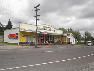
Broadwood is a town about 25 km to the north of the north side of the Hokianga harbour, in Northland, New Zealand. Herekino is 21 km to the west, and Mangamuka Bridge is the same distance to the east.
Pukepoto is a town in Northland, New Zealand. It lies south west of Kaitaia and north east of Ahipara. The Herekino Forest lies to the south east.

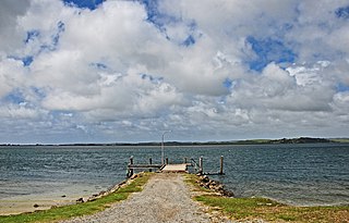
Whangape Harbour is a harbour on the west coast of Northland, New Zealand. There is a settlement called Whangape on the northern side of the harbour. Another, called Pawarenga, is located on the southern side. Kaitaia is 42 km north east.
Waikare is a locality in Northland, New Zealand. The Waikare River flows from the Russell Forest past Waikare and into the Waikare Inlet, which leads into the Bay of Islands.
Panguru is a community in the northern Hokianga harbour, in Northland, New Zealand. The Whakarapa Stream flows from the Panguru Range in the Warawara Forest to the west, through Panguru and into the Hokianga.
Waiharara is a community at the base of the Aupouri Peninsula in Northland, New Zealand. State Highway 1 runs through the community. To the west is Aupouri Forest, and beyond that Ninety Mile Beach. To the east is Rangaunu Harbour. Houhora is 22 km north west, and Awanui is 16 km south east. Lake Waiparera, 35 metres above sea level, is immediately to the north west.
Rawhiti is a small beachfront town about 27km from Russell in the Bay of Islands of New Zealand.
Karetu is a community in the Northland Region of the North Island of New Zealand. Kawakawa is to the west, and Waikare is northeast. The Karetu River flows from the Russell Forest in the southeast through Karetu, and joins the Kawakawa River shortly before it flows into the Bay of Islands.
Motatau or Mōtatau is a locality in the Northland Region of the North Island of New Zealand. Maromaku is to the east. The Taikirau Stream flows from east through Motatau and then runs northwest to join the Waiharakeke Stream. The North Auckland Line runs through Motatau.
Pipiwai is a locality in the Te Horo valley in Northland, New Zealand. Whangārei is about 35 km to the southeast. Titoki is about 16 km to the south.
Rawhitiroa is a locality situated in South Taranaki, New Zealand. It is positioned approximately 6.5 km east of Eltham.
Glorit is a rural community in the Auckland Region of New Zealand's North Island. State Highway 16 runs through the area, connecting to Tauhoa 12 km to the north and Helensville to the south.
Poukawa is a rural community in the Hastings District and Hawke's Bay Region of New Zealand's North Island.
 ]
]