Awanui

Last updated • 8 min readFrom Wikipedia, The Free Encyclopedia

Awanui
Awanui
Coordinates: 35°2′52″S173°15′22″E / 35.04778°S 173.25611°E / -35.04778; 173.25611
CountryNew Zealand
Region Northland Region
District Far North District
WardTe Hiku
Electorates
Government
  Territorial Authority Far North District Council
  Regional council Northland Regional Council
Area
[1]
  Total0.96 km2 (0.37 sq mi)
Population
 (June 2022) [2]
  Total580
  Density600/km2 (1,600/sq mi)
Postcode
0486

Awanui is an historical river port in the far north of New Zealand, on the banks of the Awanui River just before it flows into Rangaunu Bay. Awanui lies at the south end of the Aupouri Peninsula in the Far North District Council of the Northland Region, approximately 7 km north of Kaitaia. The river port has ceased operation and a recreational wharf is located at Unahi, on the shore of Rangaunu Bay, approximately 3 km north of the township. The traditional name of Awanui was Kaiwaka [3] and Awanui proper refers to the "River at Kaiwaka". According to the 2013 New Zealand census, Awanui has a population of 339, a decrease of 9 people since the 2006 census. [4]

Contents

The Tangata Whenua of the locality are represented by two neighbouring marae. Mahimaru Marae is located on State Highway 10, representing the Ngai Takoto hapu. Further along State Highway 10 is Kareponia Marae and the Patukoraha hapu o Ngati Kahu Iwi [5]

For much of the 20th century, Awanui was dominated by the Kaitaia Co-operative Dairy Factory, located immediately north of the township. The factory was constructed in 1926, which included the current wharf structure at Unahi. [6] In 1986, the Kaitaia Co-operative merged with the neighbouring Northland Dairy Company. A sequence of such mergers would eventually form Fonterra. Given the distance away from markets, together with improved farming technology and transportation methods, these mergers eventually forced the factory at Awanui to close by the early 1990s. Dairy farms remain active in the area, although smaller, with milk being transported to the Kauri Dairy Factory just north of Whangarei, approximately 100 km south.

In the 1920s, kauri timber and gum from Kaitaia moved to the coast through Awanui. [7]

State Highway 1 and 10 intersect at Awanui. Waiharara is 16 km to the north west, Kaingaroa is about 6 km to the north east, and Kaitaia is 7 km south. [8]

History and culture

Subritzky family

Early in 1868, John Anton Subritzky and his family sold up their business interests in Maldon, Australia and sailed to New Zealand aboard the barquentine Prince Alfred, arriving first in the Port of Auckland, and then sailing aboard a family schooner to Houhora and the Mount Camel Station, a large estate owned by his older brothers Captain Ludolph Johann and Heinrich Wilhelm.

The Awanui Hotel.jpg
Subritzkys General Store.jpg
The Homestead of Captain Alfred.jpg

Within a short time the Subritzky family owned or controlled almost all of the North from Awanui northward - the town of Awanui was built by the Subritzkys and their extended family, both Pakeha and Maori. The hub of the Subritzky family operations was the Mount Camel Station, and their influence on the Far North for the next fifty years stretched far and wide. They imported cattle and developed their own breed of shorthorn. They developed a shipping link with Auckland, transporting many of the early pioneering families into the northern districts. The Subritzkys also established flax mills and began processing fibres for sales and export. Then came the days of the gum diggers, and for the rest of the 1800s and well into the 1900s it was the gum trade which provided much of the prosperity in Northland.

Elingamite tragedy

On the 5 November 1902, the steamer Elingamite had sailed from Sydney bound for Auckland. On the morning of the 9th the ship encountered a dense fog and the engines were slowed to half speed. The Elingamite was a large inter-colonial passenger steamer, and carried nearly two hundred people.

A ship's look-out managed to cry out "Breakers ahead!", but it was too late, and the ship ploughed on straight ahead and was broken on the rocks of West King Island. Within minutes the ship took on a large volume of water. There were six lifeboats on board and they were immediately launched. The captain stayed with his ship until she was fully under, when he was washed into the sea and picked up by one of the lifeboats.

Under the command of the Executive Officer L. Berkett, Number Two lifeboat struck out to find help. He took the lifeboat round North Cape and down the east coast towards Houhora. They landed just north of Mount Camel, and several of the party stumbled overland through the scrub to the Houhora Hotel to raise the alarm. The Evans family sent a telegram to Auckland and a rescue fleet was raised. HMS Penguin, SS Omapere, and SS Clansman were despatched from Auckland and took part in the search and rescue, as did the auxiliary schooner of the Subritzky fleet, the Greyhound.

Meanwhile, at Houhora the locals took things into their own hands. They despatched a rider to Awanui to alert the crew of the Greyhound, which was known to be in port. They also knew that a passenger ship, the Zealandia, was sailing up the coast en route to Australia and would soon be passing Mount Camel. Members of the Wagener, Northwood and McIntosh families put to sea in Peter McIntosh's whaleboat and succeeded in getting the Zealandia to hove to. They informed the captain and he immediately got under way at all speed, however, leaving behind a very exhausted whaleboat crew to their own devices some 25 miles out to sea. [nb 1]

On the evening of the 10 November 1902, Captain Alfred Subritzky, [9] master of the Greyhound, was asleep at his home in Awanui, and his ship tied up alongside the Subritzky wharf. He was awoken by the sound of hoofbeats, a man galloping on a horse calling his name "Captain Subritzky!" The rider drew up outside the house, having ridden hard down from Houhora, all the while yelling "The Elingamite's gone down! The Elingamite's gone down!" "Where's she gone down son?" asked Captain Subritzky. "She hit the Three Kings, sir," he replied.

After checking his pocket watch, Captain Subritzky realised that the tides were all wrong and the bar at the harbour entrance was hardly covered by the incoming sea. He hurried to the Greyhound, roused the crew and made ready for sea wearing sea-boots and pyjamas. They poled down the Awanui River, then ran up all available canvas - the ship still had to clear the bar. The Greyhound raced at the bar with the auxiliary engine running and the sails set "Goose Wing" fashion, one boom on the port beam, one boom on the starboard beam and the wind blowing from directly astern. The bow section cleared and then there was a terrific thump as the keel struck the bar, but the vessel shuddered her way over then ploughed northward and into the open sea. The race for the survivors was on.

The Three Kings Islands are located at the very tip of the North Island. The Greyhound was the first ship to commence the search and lifted three dead men from the water, later identified from documents in their clothing as Messer's Green, Parker and C. Johnson. Captain Subritzky wanted to hand the bodies over to the SS Clansman and continue searching further out to sea. However, the master of the Clansman refused to take possession of them, and so the Greyhound was forced to return to Awanui due to the decaying of the remains. The three deceased were buried in an unmarked grave at Saint Joseph's churchyard in Awanui by the crew of the Greyhound and the Reverend Merton. [10]

World War II

A Royal New Zealand Air Force aerodrome and base was located nearby at Waipapakauri during World War II. At the end of hostilities in 1945, the airbase was closed and facilities abandoned, the far more suitable Kaitaia Airport nearby being developed with a paved runway.

Marae

Awanui has three marae affiliated with Ngāi Takoto: Marae and Te Whakamomoringa meeting house, Te Pā a Parore Marae and Te Pā A Parore meeting house, and Waimanoni Marae and Wikitoria meeting house. It also has a marae affiliated with the Ngāti Kahu hapū of Patu Kōraha: Kareponia Marae and Patukoraha meeting house. [11] [12]

Demographics

Statistics New Zealand describes Awanui as a rural settlement. It covers 0.96 km2 (0.37 sq mi) [1] and had an estimated population of 580 as of June 2022, [2] with a population density of 604 people per km2. Awanui is part of the larger Rangaunu Harbour statistical area. [13]

Historical population
YearPop.±% p.a.
2006351    
2013339−0.50%
2018402+3.47%
Source: [14]

Awanui had a population of 402 at the 2018 New Zealand census, an increase of 63 people (18.6%) since the 2013 census, and an increase of 51 people (14.5%) since the 2006 census. There were 123 households, comprising 198 males and 210 females, giving a sex ratio of 0.94 males per female, with 108 people (26.9%) aged under 15 years, 90 (22.4%) aged 15 to 29, 156 (38.8%) aged 30 to 64, and 45 (11.2%) aged 65 or older.

Ethnicities were 49.3% European/Pākehā, 74.6% Māori, 6.7% Pacific peoples, 1.5% Asian, and 2.2% other ethnicities. People may identify with more than one ethnicity.

Of those people who chose to answer the census's question about religious affiliation, 36.6% had no religion, 38.1% were Christian, 15.7% had Māori religious beliefs, 1.5% were Hindu and 1.5% had other religions.

Of those at least 15 years old, 15 (5.1%) people had a bachelor or higher degree, and 84 (28.6%) people had no formal qualifications. 15 people (5.1%) earned over $70,000 compared to 17.2% nationally. The employment status of those at least 15 was that 132 (44.9%) people were employed full-time, 45 (15.3%) were part-time, and 33 (11.2%) were unemployed. [14]

Education

Awanui School is a contributing primary (years 1-6) school with a roll of 42 students as of April 2023. [15] [16] Awanui School first opened in 1872 as a native school, and moved to its current site in 1915. [17]

Te Rangi Āniwaniwa is a composite school serving years 1-15, with a roll of 188 students as of April 2023. [15] [18] Te Rangi Āniwaniwa opened in 1993, [19] and teaches entirely in the Māori language. [18]

Both schools are coeducational.

Notes

  1. The whaleboat used by the Houhora families in this rescue now rests in the Auckland War Memorial Museum.

Related Research Articles

<span class="mw-page-title-main">Northland Region</span> Region of New Zealand

The Northland Region is the northernmost of New Zealand's 16 local government regions. New Zealanders sometimes refer to it as the Winterless North because of its mild climate all throughout the year. The main population centre is the city of Whangārei, and the largest town is Kerikeri. At the 2018 New Zealand census, Northland recorded a population growth spurt of 18.1% since the previous 2013 census, placing it as the fastest growing region in New Zealand, ahead of other strong growth regions such as the Bay of Plenty Region and Waikato.

<span class="mw-page-title-main">Kaitaia</span> Town in the North Island of New Zealand

Kaitaia is a town in the Far North District of New Zealand, at the base of the Aupouri Peninsula, about 160 km northwest of Whangārei. It is the last major settlement on State Highway 1. Ahipara Bay, the southern end of Ninety Mile Beach, is 5 km west.

<span class="mw-page-title-main">Ngāti Whātua</span> Māori iwi in New Zealand

Ngāti Whātua is a Māori iwi (tribe) of the lower Northland Peninsula of New Zealand's North Island. It comprises a confederation of four hapū (subtribes) interconnected both by ancestry and by association over time: Te Uri-o-Hau, Te Roroa, Te Taoū, and Ngāti Whātua-o-Ōrākei. The four hapū can act together or separately as independent tribes.

<span class="mw-page-title-main">Kaikohe</span> Town in the Northland Region of New Zealand

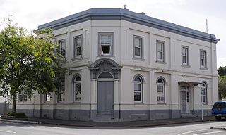
Kaikohe is the seat of the Far North District of New Zealand, situated on State Highway 12 about 260 km from Auckland. It is the largest inland town and highest community above sea level in the Northland Region. With a population of over 4000 people it is a shopping and service centre for an extensive farming district and is sometimes referred to as "the hub of the north".

<span class="mw-page-title-main">Ruatāhuna</span> Place in Bay of Plenty, New Zealand

Ruatāhuna is a small town in the remote country of Te Urewera, in the northeast of New Zealand's North Island. It is 90 kilometres directly west of Gisborne, and 18 kilometres northwest of Lake Waikaremoana. By road, it is 50 kilometres south-east of Murupara, and 110 kilometres north-west of Wairoa. It is on the upper reaches of the Whakatāne River, and surrounded on three sides by the Te Urewera protected area, formerly the Te Urewera National Park. The road that runs from Murupara through Ruatahuna to Āniwaniwa on Lake Waikaremoana, a large part of which is unsealed, used to be designated as part of State Highway 38. It is a subdivision of the Galatea-Murupara ward of the Whakatāne District.

<span class="mw-page-title-main">Aupouri Peninsula</span> Northernmost peninsula of New Zealand

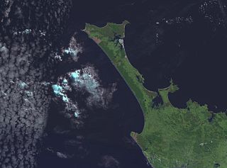
The Aupouri Peninsula is a tombolo at the northern tip of the North Island of New Zealand. It projects between the Tasman Sea to the west and the Pacific Ocean to the east. It constitutes the northern part of the Far North District, incorporating North Cape, Houhora and the northern half of Awanui.

<span class="mw-page-title-main">Te Aupōuri</span> Māori iwi in New Zealand

Te Aupōuri is the second northernmost Māori iwi, located north of Kaitaia, Northland, New Zealand, a region known as the Te Hiku o te Ika. The iwi is one of the six Muriwhenua iwi of the far north of the North Island.

<span class="mw-page-title-main">Ahipara</span> Place in Northland Region, New Zealand

Ahipara is a town and locality in Northland, New Zealand at the southern end of Ninety Mile Beach, with the Tauroa Peninsula to the west and Herekino Forest to the east. Ahipara Bay is to the north west. Kaitaia is 14 km to the north east, and Pukepoto is between the two.

<span class="mw-page-title-main">Herekino</span> Place in Northland Region, New Zealand

Herekino is a locality in Northland, New Zealand. It lies 26 km south west of Kaitaia. The Herekino Harbour, also called the Herekino River, is an estuary and inlet from the Tasman Sea to the west. The Herekino Forest, which contains a stand of large kauri, is to the north, and the Tauroa Peninsula lies to the north west.

<span class="mw-page-title-main">Houhora</span> Place in Northland Region, New Zealand

Houhora is a locality and harbour on the east side of the Aupouri Peninsula of Northland, New Zealand. It is 41 km (25 mi) north of Kaitaia. Waihopo, Te Raupo, Pukenui, Raio and Houhora Heads are associated localities on the southern shores of the harbour. State Highway 1 passes through all these localities except for Houhora Heads. Te Kao is 24 km north west, and Waiharara is 22 km south east.

<span class="mw-page-title-main">Whangape Harbour</span>

Whangape Harbour is a harbour on the west coast of Northland, New Zealand. There is a settlement called Whangape on the northern side of the harbour. Another, called Pawarenga, is located on the southern side. Kaitaia is 42 km north east.

Waiharara is a community at the base of the Aupouri Peninsula in Northland, New Zealand. State Highway 1 runs through the community. To the west is Aupouri Forest, and beyond that Ninety Mile Beach. To the east is Rangaunu Harbour. Houhora is 22 km north west, and Awanui is 16 km south east. Lake Waiparera, 35 metres above sea level, is immediately to the north west.

<span class="mw-page-title-main">Ngāi Takoto</span> Māori iwi in New Zealand

Ngāi Takoto is a Māori iwi from Northland, New Zealand. The iwi is one of the six Muriwhenua iwi of the far north of the North Island. Ngāi Takoto trace their whakapapa (ancestry) back to Tuwhakatere, and trace their arrival in New Zealand to the Kurahaupo waka (canoe). The rohe of the iwi is focused on the upper North Island and extends to Kermadec Islands, Three Kings Island, Cape Reinga, Pao Island, Ninety Mile Beach, Waimimiha River, Ohaku hills, Whangatane River, Rangaunu Harbour and North Cape.

<span class="mw-page-title-main">Ngāti Kahu</span> Māori iwi in New Zealand

Ngāti Kahu is a Māori iwi of Northland, New Zealand. The iwi is one of the six Muriwhenua iwi of the far north of the North Island. Ngāti Kahu take their name from their founding ancestress, Kahutianui, and link their ancestry back to the waka Māmaru. The captain of Māmaru was Te Parata who married Kahutianui.

<span class="mw-page-title-main">Ngāti Kurī</span> Māori iwi in New Zealand

Ngāti Kurī is a Māori iwi from Northland, New Zealand. The iwi is one of the five Muriwhenua iwi of the far north of the North Island. Ngāti Kurī trace their whakapapa (ancestry) back to Pōhurihanga, the captain of the waka (canoe) Kurahaupō. Kurī, in Māori, means "dog". The rohe of the iwi is focused on the most northern tip of the North Island and includes the Kermadec Islands, Manawatāwhi / Three Kings Islands, Cape Reinga / Te Rerenga Wairua, Ninety Mile Beach, Parengarenga Harbour, Te Kao and Houhora.

<span class="mw-page-title-main">Te Rarawa</span> Māori iwi in New Zealand

Te Rarawa is a Māori iwi of Northland, New Zealand. The iwi is one of five Muriwhenua iwi of the far north of the North Island.

<span class="mw-page-title-main">Te Uri-o-Hau</span> Māori iwi in New Zealand

Te Uri-o-Hau is a Māori iwi (tribe) based around New Zealand's Kaipara Harbour. It is both an independent iwi and a hapū (sub-tribe) of the larger Ngāti Whātua iwi, alongside Ngāti Whātua-o-Ōrākei, Te Roroa and Te Taoū. Its rohe includes Dargaville, Maungaturoto, Mangawhai, Kaiwaka and Wellsford.

<span class="mw-page-title-main">Awanui River</span> River in Northland, New Zealand


The Awanui River is a river in the far north of New Zealand, close to the point at which the Aupouri Peninsula joins the rest of the Northland Peninsula. The Awanui flows first west and then north, for a total of 30 kilometres (19 mi), before flowing into Rangaunu Harbour. The town of Kaitaia is along its banks.

Rangaunu Harbour is a shallow harbour in the far north of New Zealand. It is situated on the east coast at the base of the Aupouri Peninsula. The name in Māori means "To pull out a shoal of fish". With an area of 115 square kilometres (44 sq mi) it is the fifth-largest harbour in New Zealand.

References

  1. 1 2 "ArcGIS Web Application". statsnz.maps.arcgis.com. Retrieved 22 March 2022.
  2. 1 2 "Subnational population estimates (RC, SA2), by age and sex, at 30 June 1996-2022 (2022 boundaries)". Statistics New Zealand . Retrieved 25 October 2022. (regional councils); "Subnational population estimates (TA, SA2), by age and sex, at 30 June 1996-2022 (2022 boundaries)". Statistics New Zealand . Retrieved 25 October 2022. (territorial authorities); "Subnational population estimates (urban rural), by age and sex, at 30 June 1996-2022 (2022 boundaries)". Statistics New Zealand . Retrieved 25 October 2022. (urban areas)
  3. Hayward-Howie, Pare (29 January 2013). "Charlie Hayward - Awanui, near Kaitaia. Born 1919". Maori Childhood 1920s - 1930s. Archived from the original on 30 October 2014. Retrieved 30 October 2014.
  4. 2013 Census QuickStats about a place  : Awanui
  5. "Māori Maps". Maorimaps.com. Retrieved 20 September 2015.
  6. "Awanui and the Kaitaia Dairy Company Wharf". Donhammondimage.co.nz. 10 December 1924. Retrieved 20 September 2015.
  7. "Northland places". Te Ara: The Encyclopedia of New Zealand . Retrieved 20 September 2015.
  8. Peter Dowling, ed. (2004). Reed New Zealand Atlas. Reed Books. pp. map 3. ISBN   0-7900-0952-8.
  9. Captain Alfred Subritzky
  10. Mike Subritzky,Subritzky Shipping: a heritage of sail 1843-1993, Three Feathers, 1993, ISBN   0473018497
  11. "Te Kāhui Māngai directory". tkm.govt.nz. Te Puni Kōkiri.
  12. "Māori Maps". maorimaps.com. Te Potiki National Trust.
  13. 2018 Census place summary: Rangaunu Harbour
  14. 1 2 "Statistical area 1 dataset for 2018 Census". Statistics New Zealand. March 2020. 7000025–7000027.
  15. 1 2 "New Zealand Schools Directory". New Zealand Ministry of Education. Retrieved 12 December 2022.
  16. Education Counts: Awanui school
  17. "History". Awanui School. Retrieved 22 March 2022.
  18. 1 2 Education Counts: Te Rangi Aniwaniwa
  19. "Te Rangi Āniwaniwa Charter" (PDF) (in Māori). Te Rangi Āniwaniwa. 2020. p. 2. Retrieved 22 March 2022. Nā, ka tūwheratia Te Rangi Āniwaniwa i te tau 1993

Further reading