Auckland Airport is an international airport serving Auckland, the most populous city of New Zealand. It is the largest and busiest airport in the country, with over 16 million passengers served in the year ended August 2023. The airport is located near Māngere, a residential suburb, and Airport Oaks, a service-hub suburb 21 kilometres (13 mi) south of the Auckland city centre. It serves as the principal hub for Air New Zealand, and the New Zealand operating base for Jetstar.

Christchurch Airport is the main airport that serves Christchurch, New Zealand. It is located 12 kilometres (7.5 mi) to the northwest of the city centre, in the suburb of Harewood. Christchurch (Harewood) Airport officially opened on 18 May 1940 and became New Zealand's first international airport on 16 December 1950. It is the second busiest airport in New Zealand, after Auckland and before Wellington by annual passengers, and the second busiest, after Auckland, by aircraft movements.
New Zealand National Airways Corporation, popularly known as NAC, established by the New Zealand National Airways Act, 1945, was the national domestic airline of New Zealand until 1978 when it amalgamated with New Zealand's international airline, Air New Zealand. The airline was headquartered in Wellington.

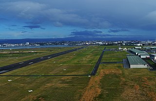
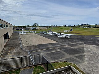
Wellington International Airport is an international airport located in the suburb of Rongotai in Wellington. It lies 3 NM or 5.5 km south-east from the city centre. It is a hub for Air New Zealand and Sounds Air. Wellington International Airport Limited, a joint venture between Infratil and the Wellington City Council, operates the airport. Wellington is the third busiest airport in New Zealand after Auckland and Christchurch, handling a total of 3,455,858 passengers in the year ending June 2022, and the third busiest in terms of aircraft movements. The airport, in addition to linking many New Zealand destinations with national and regional carriers, also has links to major cities in eastern Australia. It is the home of some smaller general aviation businesses, including the Wellington Aero Club, which operates from the general aviation area on the western side of the runway.

Prince George Airport is an airport that serves Prince George, British Columbia, Canada, and the surrounding area. It is located just within the southern boundary of the city, 2.8 nautical miles southeast, and is run by the Prince George Airport Authority.
Hamilton Airport is an airport located 14 kilometres south of the city of Hamilton in the Waikato region, in New Zealand. It is sited at Rukuhia, which was the name of the Royal New Zealand Air Force base on that site during World War II.

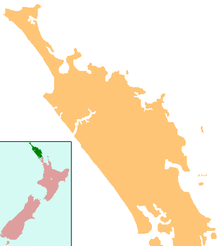
Whangārei Airport is an airport 4 nautical miles to the south east of Whangārei city, in the suburb of Onerahi, on the east coast of Northland in the North Island of New Zealand. The airport has a single terminal with two gates.

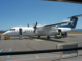
Palmerston North Airport, originally called Milson Aerodrome, is an airport in the Manawatū-Whanganui region of New Zealand, serving Palmerston North City and the Central North Island regions. It is located in the suburb of Milson, on the outskirts of Palmerston North, New Zealand, approximately 5.5 km (3.4ml) NE from the central business district of Palmerston North City. The airport is 100% owned by the Palmerston North City Council and covers an area of 208ha. The airport is New Zealand's 8th busiest and handled a total of 515,727 passengers in the 2016 financial year. The airport handles around 30 commercial passenger flights per day to and from Auckland, Christchurch, Hamilton, Napier, Nelson as well as cargo flights on week nights between Auckland and Christchurch.

Norfolk Island Airport, also referred to as Norfolk Island International Airport, is the only airport on Norfolk Island, an external territory of Australia. The island is located in the Pacific Ocean between Australia, New Zealand, and New Caledonia. The airport is operated by the Norfolk Island Regional Council, and is on the west side of the island.
South Pacific Airlines of New Zealand was a New Zealand airline, operating between 1960 and 1966. It is regarded as a forerunner to Ansett New Zealand.
Tauranga Airport is an airport serving the city of Tauranga, New Zealand. It is located adjacent to Tauranga Harbour in the suburb of Mount Maunganui, approximately 3 km northeast of Tauranga CBD. The terminal is located to the north of the runway, on Jean Batten Drive, and consists of a two-storey building with four tarmac gates. Air New Zealand serves the airport, with flights to Auckland, Wellington and Christchurch. A further two regional airlines also operate to the airport, as well as scenic and charter flights, skydiving operations and general aviation.

New Plymouth Airport serves the city of New Plymouth, and the surrounding region of Taranaki. It is located on the west coast of New Zealand's North Island and is 11 km from the city centre, on State Highway 3 north to Auckland, and 4 km from the outer suburb/satellite town of Bell Block.

Invercargill Airport is a fully secured controlled international designated airport located 1.6 km west of the Central business district of Invercargill at the bottom of the South Island of New Zealand. It is the southernmost controlled airport in the Commonwealth. Formed on land reclaimed from the Waihopai/New River Estuary in 1938, the airport was prone to flooding, notably in 1984 when it was inoperable for two months. The Invercargill City Council considered moving the airport back to Dawson Farm, Myross Bush, the original site up to 1942. Instead, a large flood protection scheme was built, but during its construction heavy rain and an unusually high tidal surge flooded it again in 1987. There have been no problems since. The airport has a main secured terminal, a backup international secured terminal and 5 tarmac gates. Invercargill is the eleventh-busiest airport in New Zealand by passenger traffic.

Barrier Air is a New Zealand airline that was established in 1983 by Jim Bergman as Great Barrier Airlines. The head office is located at the Domestic Terminal at Auckland Airport in Māngere, with additional offices in the terminal buildings at Great Barrier Aerodrome, Kaitaia Airport and North Shore Aerodrome.
North Shore Aerodrome, also called North Shore Airport and Dairy Flat Airfield, is a small, uncontrolled aerodrome located 2 nmi (3.7 km) south southwest of Silverdale, near Auckland in New Zealand's North Island.
Kerikeri Airport, also known as Bay of Islands Airport, is an airport at Kerikeri, New Zealand. It is a ten-minute drive from Kerikeri and a 50-minute flight to and from Auckland Airport.

Nelson Airport is located 6 km (3.7 mi) south-west of central Nelson, New Zealand, in the suburb of Annesbrook. Approximately 1.2 million passengers and visitors use the airport terminal annually. Passenger numbers for the 2017 financial year were 1,000,373, up from 865,203 in 2016.
Rotorua Airport is an airport in Rotorua, New Zealand. It is located on Te Ngae Road (SH30) in the suburb of Rotokawa, approximately 6 km north east of Rotorua CBD. The terminal consists of a two-storey building with six tarmac gates and is home to a cafe, book store and conference room. There are general aviation hangars located to both the north and the south of the main terminal, as well as an avgas pump at the southern end of the apron. The airport's main runway (18R/36L) is 2114m long and is sealed with asphalt. There is also a shorter grass runway (18L/36R) which runs parallel to the main runway, although the proximity of the two runways means that they can't be used simultaneously.

Sunair is an airline headquartered in Tauranga, on the North Island of New Zealand. It operates scheduled services, flying to Gisborne, Hamilton, Wairoa, Napier, Whangārei, Whitianga, Motiti Island and Great Barrier Island. It also has charter and pilot training operations. Sunair has fifteen aircraft.
Kaikohe Aerodrome is an airfield south-east of Kaikohe in the Northland region of New Zealand. Built in 1942 as a US Marines bomber base, is the largest grass strip in the Southern hemisphere used now by general aviation. Other than powered aircraft, gliders use the airfield, and an area next to the runways is used by model airplane flyers. There are skydiving operations as well, with a landing spot near the old terminal.