
Merrill C. Meigs Field Airport was a single-runway airport in Chicago that was in operation from 1948 to 2003, when it was bulldozed overnight by then-mayor Richard M. Daley. The airport was located on Northerly Island, an artificial peninsula on Lake Michigan adjacent to downtown Chicago, the second-largest business district in the Western Hemisphere. By 1955, Meigs Field had become the busiest single-strip airport in the United States. The airport was a familiar sight on the downtown lakefront. The latest air traffic tower was built in 1952, and the terminal was dedicated in 1961. The airfield was named for Merrill C. Meigs.

Air Vanuatu was an airline with its head office in Air Vanuatu House, Port Vila, Vanuatu. It was Vanuatu's national flag carrier, operating to Australia, New Zealand, New Caledonia and points in the South Pacific. Its main base was Bauerfield International Airport, Port Vila. In May 2024 the airline was placed into liquidation by the Government of Vanuatu.
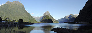
Milford Sound is a fiord in the south west of New Zealand's South Island within Fiordland National Park, Piopiotahi Marine Reserve, and the Te Wahipounamu World Heritage site. It has been judged the world's top travel destination in an international survey and is acclaimed as New Zealand's most famous tourist destination. Rudyard Kipling called it the eighth Wonder of the World. The fiord is most commonly accessed via road by tour coach, with the road terminating at a small village also called Milford Sound.

Fiordland is a geographical region of New Zealand in the south-western corner of the South Island, comprising the westernmost third of Southland. Most of Fiordland is dominated by the steep sides of the snow-capped Southern Alps, deep lakes, and its steep, glacier-carved and now ocean-flooded western valleys. The name "Fiordland" comes from a variant spelling of the Scandinavian word for this type of steep valley, "fjord". The area of Fiordland is dominated by, and very roughly coterminous with, Fiordland National Park, New Zealand's largest National Park.

Fiordland National Park is a national park in the south-west corner of South Island of New Zealand. It is the largest of the 13 national parks in New Zealand, with an area covering 12,607 km2 (4,868 sq mi), and a major part of the Te Wāhipounamu a UNESCO World Heritage Site established in 1990. The park is administered by the Department of Conservation. The southern ranges of the Southern Alps cover most of Fiordland National Park, combined with the deep glacier-carved valleys.

Donegal Airport is a regional airport in Ireland, serving County Donegal and the north-west. It is located on the coast, 2 NM south-west of Bunbeg in Carrickfinn, a townland in The Rosses, a district in north-west County Donegal. It is about a 15-minute drive from Dungloe and Gweedore and 45 minutes from Letterkenny. It was generally known until the 1990s, and is still popularly known within County Donegal, as Carrickfinn Airport, from which its airport code (CFN) is derived.

McClellan–Palomar Airport is a public airport three miles southeast of Carlsbad in San Diego County, California. It is owned by the County of San Diego. The airport is used for both general aviation and commercial aviation. As of March 2013, the airport was the fourth-busiest single runway airport in the United States.
Mount Cook Airline was a regional airline based in Christchurch, New Zealand. Formerly part of the Mount Cook Group and latterly a subsidiary of Air New Zealand, it operated scheduled services throughout the country under the Air New Zealand Link brand. In December 2019, the brand name was retired with all services operated under the Air New Zealand banner.

Glacier Park International Airport is in Flathead County, Montana, United States, six miles northeast of Kalispell. The airport is owned and operated by the Flathead Municipal Airport Authority, a public agency created by the county in 1974. The airport is near Glacier National Park.

Land's End Airport, situated near St Just in Penwith, 5 NM west of Penzance, in Cornwall, is the most south westerly airport of mainland Britain. The airport is owned by the Isles of Scilly Steamship Company (ISSC). ISSC's subsidiary Land's End Airport Limited operates the airport, and another subsidiary, Isles of Scilly Skybus, operates a regular passenger service to St Mary's in the Isles of Scilly as well as scenic flights around west Penwith.

Pago Pago International Airport, also known as Tafuna Airport, is a public airport located 7 miles (11.3 km) southwest of the central business district of Pago Pago, in the village and plains of Tafuna on the island of Tutuila in American Samoa, an unincorporated territory of the United States.
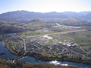
Queenstown International Airport is an international airport located in Frankton, Otago, New Zealand, which serves the resort town of Queenstown. The airport handled 2.25 million passengers as of 2018 making it the fourth busiest airport in New Zealand by passenger traffic. The airport is known for its scenery and challenging approach to land due to the nearby high terrain and proximity to housing.
Wānaka Airport is an airport serving the rural town of Wānaka in Otago, New Zealand. The airport currently has scheduled commercial flights from one airline, SoundsAir, with Air New Zealand having ceased flights to the airport in 2013. It largely serves as a base for scenic and charter flights to destinations such as Milford Sound and Mount Aspiring National Park. The airport is located beside State Highway 6, on a plateau above the small village of Luggate, and is 10 km south-east of Wānaka township. It was originally a private airstrip owned by Tim Wallis, but in 1985 it became the main commercial airport for Wānaka, replacing Mount Iron Aerodrome.
Kerikeri Airport, also known as Bay of Islands Airport, is an airport at Kerikeri, New Zealand. It is a ten-minute drive from Kerikeri and a 50-minute flight to and from Auckland Airport.

Air West Coast is an airline based in Greymouth, New Zealand.

Salt Air is a New Zealand charter airline based at Paihia in the Bay of Islands, in the Northland Region of the North Island.
Air Safaris is a New Zealand scenic flight and air charter company based at the Lake Tekapo Airport located 2.8 km west of the town of Lake Tekapo, off State Highway 8 in the Mackenzie District of New Zealand. The airline operates from 5 bases: Tekapo, Franz Josef, Glentanner, Twizel and Mt Cook airports. The company logo is a stylised chamois; these are wild goat-like antelope which inhabits the region of the South Island High Country.
Glenorchy Air is a scenic flight and air charter company based at Queenstown Airport, New Zealand. The company was founded by Janet and Robert Rutherford in 1992, with just one aeroplane, a Cessna 185. With the expansion of the business, a second aircraft, a Piper PA-32-300 Cherokee Six, was purchased in 1996. The Cessna 185 was sold in 2003 when it was replaced by a new Gippsland GA8 Airvan. The company took delivery of a second Airvan in 2013 and added two more before the business was sold in 2019.
Mainland Air is a general aviation, flight training and air charter company operating out of Dunedin International Airport in New Zealand.


