
The Tasman Sea is a marginal sea of the South Pacific Ocean, situated between Australia and New Zealand. It measures about 2,000 kilometres (1,200 mi) across and about 2,800 kilometres (1,700 mi) from north to south. The sea was named after the Dutch explorer Abel Janszoon Tasman, who was the first recorded European to encounter New Zealand and Tasmania. The British explorer Captain James Cook later extensively navigated the Tasman Sea in the 1770s as part of his first voyage of exploration.

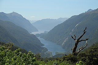
Fiordland is a geographic region of New Zealand in the south-western corner of the South Island, comprising the western-most third of Southland. Most of Fiordland is dominated by the steep sides of the snow-capped Southern Alps, deep lakes, and its steep, glacier-carved and now ocean-flooded western valleys. The name "Fiordland" comes from a variant spelling of the Scandinavian word for this type of steep valley, "fjord". The area of Fiordland is dominated by, and very roughly coterminous with, Fiordland National Park, New Zealand's largest National Park.
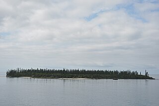
The Isle of Pines is an island located in the Pacific Ocean, in the archipelago of New Caledonia, an overseas collectivity of France. The island is part of the commune (municipality) of L'Île-des-Pins, in the South Province of New Caledonia. The Isle of Pines is nicknamed l'île la plus proche du paradis.

Waiau River is the largest river in the Southland Region of New Zealand. It is the outflow of Lake Te Anau, flowing from it into Lake Manapouri 10 kilometres (6 mi) to the south, and from there flows south for 70 kilometres (43 mi) before reaching the Foveaux Strait 8 kilometres (5 mi) south of Tuatapere. It also takes water from Lake Monowai.

The Campbell Islands are a group of subantarctic islands, belonging to New Zealand. They lie about 600 km south of Stewart Island. The islands have a total area of 113.31 km2 (43.75 sq mi), consisting of one big island, Campbell Island, and several small islets, notably Dent Island, Isle de Jeanette Marie (0.11 km2 or 0.042 sq mi, Folly Island, Jacquemart Island, and Monowai Island. Ecologically, they are part of the Antipodes Subantarctic Islands tundra ecoregion. The islands are one of five subantarctic island groups collectively designated as a World Heritage Site by UNESCO.

HMNZS Monowai (F59) was a former Peninsular and Oriental Steam Navigation Company (P&O) merchant vessel. At the outbreak of World War II she became an armed merchant cruiser of the Royal New Zealand Navy (RNZN). She subsequently became HMS Monowai, a Landing Ship, Infantry and mostly operated as a troopship. In 1946 she returned to her old trade as a passenger ship.

Icebreaker Glacier is a large valley glacier 10 miles (16 km) northeast of Mount Monteagle that flows southeast from the Mountaineer Range to Lady Newnes Bay, Victoria Land, Antarctica. Below Hermes Point its flow coalesces with that of Fitzgerald Glacier. The glacier was named by the New Zealand Geological Survey Antarctic Expedition, 1958–59, as a tribute to the work of the complements of U.S. Navy, and U.S. Coast Guard icebreakers in Antarctic exploration, in supporting scientists and in aiding other ships.

Arpașu de Jos is a commune located in Sibiu County, Romania. It is composed of three villages: Arpașu de Jos, Arpașu de Sus (Felsőárpás) and Nou Român.
Sofular is a village and municipality in the Tovuz Rayon of Azerbaijan. It has a population of 443.
The Wilmot Pass is a 671 m (2,201 ft) high pass on the main divide of New Zealand's South Island. It connects Doubtful Sound, a deep indentation in the coast of Fiordland, to the valley of the West Arm of Lake Manapouri. The pass is named after E. H. Wilmot, a former surveyor-general of New Zealand, who had noted it while surveying the area in 1897. It lies between Mount Wilmot and Mount Mainwaring. On the east side the Spey River drains to Lake Manapouri and on the west side the Lyvia River drains to Deep Cove.

The Hunter Mountains of Lake Manapouri, New Zealand, were named by surveyor James McKerrow after the famous anatomist John Hunter. The Hunter Mountain Range covers an area between The South Arm and Hope Arm of Lake Manapouri South to the Green Lake.
The Electric River is a river of Fiordland, New Zealand. It arises around Lake Jaquiery in the Kaherekoau Mountains and flows eastward into Lake Monowai at June Bay.
The Grebe River is a river in Fiordland, New Zealand. It arises north-west of Lake Monowai in an area once part of the lake but cut off by an enormous landslide about 13,000 years ago. The river now flows north, between the Townley Mountains to the west, and the Hunter Mountains to the east, and into Lake Manapouri's South Arm. Its major tributaries are Jaquiery Stream, Florence Stream, Emerald Stream, and Percy Stream, all from the west.
The Robertson River is a river in Stewart Island/Rakiura, New Zealand. It rises to the east of the Tin Range and flows into the sea east of Port Pegasus.
Barrett Glacier is a glacier draining from the north slopes of the Prince Olav Mountains, about 15 nautical miles (30 km) long, flowing between the Longhorn Spurs and the Gabbro Hills to the Ross Ice Shelf. It was named by the Southern Party of the New Zealand Geological Survey Antarctic Expedition (1963–64) for Peter J. Barrett, a geologist with that party.
Mackellar Glacier is a large tributary glacier in the Queen Alexandra Range, Antarctica, flowing north along the east side of Hampton Ridge from Mount Mackellar, to enter Lennox-King Glacier. It was named by the New Zealand Geological Survey Antarctic Expedition (1961–62) in association with Mount Mackellar.

Monowai is a volcanic seamount to the north of New Zealand. It is formed by a large caldera and a volcanic cone just south-southeast from the caldera that rises to depths of 100 metres (330 ft) but its depth varies with ongoing volcanic activity, including sector collapses and the growth of lava domes. The seamount was discovered at some point between 1877 and 1977 and is one of the most active volcanoes in the Kermadec volcanic arc, with many eruptions since 1977. Volcanic activity is characterised by the emission of gas and discolouration of water, along with seismic activity and a substantial growth rate of the volcano. Ongoing hydrothermal activity has also been observed and hydrothermal vents on Monowai feature a rich fauna.


