Mechanics Bay

Last updated

Mechanics Bay
Charles Blomfield, Mechanics Bay Painting.jpg
Painting of Mechanics Bay in 1899, by Charles Blomfield.
CountryNew Zealand
City Auckland Council
Bayswater Devonport
Auckland city centre
Pfeil oben.svg
Pfeil links.svgMechanics BayPfeil rechts.svg
Pfeil unten.svg
Newmarket Parnell Ōrākei

Mechanics Bay (Māori : Te Tōangaroa) is a reclaimed bay on the Waitematā Harbour in Auckland, New Zealand. It is also the name of the area of the former bay that is now mainly occupied by commercial and port facilities. Sometimes the bay formed between Tāmaki Drive and the western reclamation edge of Fergusson Container Terminal is also referred to as Mechanics Bay.[ citation needed ]

Contents

History

The bay was called Te Tōangaroa by Tāmaki Māori, referring to the need to drag waka a long distance during low tide in the bay. [1] During the early colonial era of Auckland, Mechanics Bay was the main trading port on the Waitematā Harbour for Māori, in a separate location from the main Auckland waterfront. [2]

European settlement

Along the harbour shore between Point Britomart and St Stephen's Point in Parnell were four bays: Official Bay, Mechanics Bay, St Georges Bay and Judges Bay. Some have now disappeared due to land reclamation and the quarrying of the bordering headlands. Closest to Point Britomart was Official Bay, so called because many government officials lived there during the 1840s.

Almost contiguous with Official Bay was Mechanics Bay. It took its name from its use in housing the labour force the government had brought to construct the new capital. Mechanics Bay contained the mouth of the stream issuing from the springs in the Auckland Domain to the south. The Bay had a broad, flat beach where Māori had long been in the habit of beaching their waka (canoes).

Next to Mechanics Bay was St George's Bay and then Judges Bay, so named because three of the magistrates of the early colony built their houses there. Next to Judges Bay is St Stephen's point, where a small chapel was built.

As early as the 1860s this shore front began to be modified by the European settlers. In particular it was in order to get the railway tracks around to the bottom of Queen Street that Point Britomart was quarried away and Official Bay and Mechanics Bay filled in. Initially the railway tracks came through the gully that lay between the Auckland Domain and the suburb of Parnell, but later when a second route was formed further to the east through Meadowbank the shoreline between Mechanics Bay and Hobson Bay was also modified. St Georges Bay ceased to exist and became the shunting yard for the railway station, and Judges Bay was separated from the harbour by a railway embankment.

The major thoroughfare of Mechanics Bay is Beach Road, which once ran around the beach front of the now reclaimed Mechanics Bay. The former Auckland Railway Station is located here, an impressive brick 1930s structure designed by Gummer and Ford. Formerly located at the bottom of Queen Street, the station was moved to Beach Road to be the centrepiece for the new downtown business area of Auckland. The plan was not a success. The station was decommissioned and the railway terminal returned to its original location, now named the Britomart Transport Centre.

Aviation

New Zealand's first international airport was in Mechanics Bay. [3] The first aircraft connecting New Zealand with the rest of the world in the 1930s were flying boats. International flights from Britain by Imperial Airways via India, Singapore and Australia connected with TEAL for the Sydney to Auckland leg. Flights by Pan American from America via Hawaii also landed at Auckland. The Short Solent or Boeing 314 flying boats landed in Mechanics Bay, which was the centre of international aviation for New Zealand until the 1950s. Even after the construction of Auckland International Airport at Māngere in the 1960s, Mechanics Bay was still used by flying boats to the Pacific Islands, e.g. for the Coral Route to Fiji.

From 1962 to 1989, Mechanics Bay was home to first Tourist Air Travel, then Mount Cook Airline then Sea Bee Air operating a fleet of Grumman Goose, Grumman Widgeon and Grumman Turbo Goose amphibian aircraft for regular scheduled passenger and freight services to the islands of the Hauraki Gulf (particularly Great Barrier and Waiheke Islands) and operated charter flights to other areas such as the Bay of Islands, Manukau & Kaipara Harbours and elsewhere around the country and to Pacific islands. Operating from what is now the Marine Rescue Centre, they were located near Compass Dolphin (since destroyed in a fierce storm in the early 1990s).

The Mechanics Bay area is now filled in by the container terminal of Ports of Auckland. Auckland Marine Rescue Centre Overhead.jpg
The Mechanics Bay area is now filled in by the container terminal of Ports of Auckland.
Barack Obama waving to INFLITE & Westpac Rescue staff at Mechanics Bay before boarding his helicopter. Barack Obama at Mechanics Bay.jpg
Barack Obama waving to INFLITE & Westpac Rescue staff at Mechanics Bay before boarding his helicopter.
Mechanics Bay as seen from the Ports of Auckland SeePort Open Weekend on Auckland Anniversary Weekend in 2019 Ports of Auckland Mechanics Bay.jpg
Mechanics Bay as seen from the Ports of Auckland SeePort Open Weekend on Auckland Anniversary Weekend in 2019

Mechanics Bay also has a heliport, which has been the base for a number of sightseeing and commercial flight companies, as well as the Westpac Rescue Helicopter and NZ Police Air Support Unit known as the Eagle Helicopter. It is located next to the Auckland Marine Rescue Centre at the eastern end of the Ports of Auckland container terminal. In May 2013 a helicopter crashed in the water off Mechanics Bay, both the pilot and passenger were quickly rescued from the water unharmed by a nearby navy boat. [4]

ZK-HVN at Mechanics Bay, about to depart for Waiheke Island Bell 427 ZK-HVN at Mechanics Bay.jpg
ZK-HVN at Mechanics Bay, about to depart for Waiheke Island

Eagleflight Aviation have occupied and operated Mechanics Bay Heliport since mid-2018. A fleet of Airbus/Eurocopter H130 helicopters are operated by luxury charter company Helicopter Me. [5]

Surrounding area

At its eastern end where Beach Road turns into Parnell Rise is a major intersection, over which the railway is carried on a metal viaduct. The road to the north is The Strand which follows the shore line of the reclaimed St Georges Bay. The road to the south is Stanley Street, which turns into Grafton Road as it ascends the hill towards the hospital and Auckland Domain. Stanley Street is named for Mrs Stanley, who lived in the area during the 1850s and ran a well known and apparently well regarded girls school.

On the corner of Stanley Street and Parnell Rise is the Strand Hotel. This building is almost overpowered by the busy intersection and by the railway viaduct passing close to it. When the Strand Hotel was built in the 1840s as the Swan Hotel it stood directly on the quayside as a waterfront pub. Just opposite it on the other corner of Stanley Street stood the Native Hostel.

Long before the Europeans arrived, Māori had beached their wakas on the broad flat beach just here and right from the founding of Auckland in 1840 into the late 20th century this portion of land was reserved for their use. The 19th century hostel buildings only disappeared in the 1970s, when they were replaced by a depot for the New Zealand Post Office.

Related Research Articles

<span class="mw-page-title-main">North Shore, New Zealand</span> Subregion of Auckland, New Zealand

The North Shore is one of the major geographical regions of Auckland, the largest city in New Zealand. The area is defined as the northern shores of the Waitematā Harbour as far north as the Ōkura River.

<span class="mw-page-title-main">Waitematā Harbour</span> Harbour in Auckland, New Zealand

Waitematā Harbour is the main access by sea to Auckland, New Zealand. For this reason it is often referred to as Auckland Harbour, despite the fact that it is one of two harbours adjoining the city. The harbour forms the northern and eastern coasts of the Auckland isthmus and is crossed by the Auckland Harbour Bridge. It is matched on the southern side of the city by the shallower waters of the Manukau Harbour.

<span class="mw-page-title-main">Panmure, New Zealand</span> Suburb in Auckland, New Zealand

Panmure is an east Auckland suburb, in the North Island of New Zealand. It is located 11 kilometres southeast of the Auckland CBD, close to the western banks of the Tāmaki River and the northern shore of the Panmure Basin. To the north lies the suburb of Tāmaki, and to the west is the cone of Maungarei / Mount Wellington.

<span class="mw-page-title-main">Waitematā railway station</span> Multimodal transit station in New Zealand

Waitematā railway station, commonly known as Britomart railway station or Britomart Transport Centre, is the public transport hub in the central business district of Auckland and the northern terminus of the North Island Main Trunk railway line. It combines a railway station in a former Edwardian post office, extended with expansive modernist architectural elements, with a bus interchange. It is at the foot of Queen Street, the main commercial thoroughfare of the CBD, with the main ferry terminal just across Quay Street.

<span class="mw-page-title-main">Parnell, New Zealand</span> Suburb in Auckland, New Zealand

Parnell is a suburb of Auckland, New Zealand. It is one of New Zealand's most affluent suburbs, consistently ranked within the top three wealthiest, and is often billed as Auckland's "oldest suburb" since it dates from the earliest days of the European settlement of Auckland in 1841. It is characterised by its mix of tree-lined streets with large estates; redeveloped industrial zones with Edwardian town houses and 1920s bay villas; and its hilly topography that allows for views of the port, the Waitematā Harbour, Rangitoto Island and the Auckland Domain. To its west lies the Auckland Domain, to the south Newmarket, and to the north the Ports of Auckland.

<span class="mw-page-title-main">Saint Marys Bay, New Zealand</span> Suburb in Auckland, New Zealand

Saint Marys Bay is an inner suburb of Auckland, New Zealand.

<span class="mw-page-title-main">Riverhead, New Zealand</span> Place in Auckland Region, New Zealand

Riverhead is a small, historically predominantly working-class town located at the head of the Waitematā Harbour in the north-west of Auckland, New Zealand. It is located on the northwestern shores of the Upper Waitematā Harbour, north-east of the towns of Kumeū and Huapai.
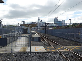
<span class="mw-page-title-main">Huapai</span> Place in Auckland Region, New Zealand

Huapai is a locality north-west of Auckland, New Zealand. State Highway 16 and the North Auckland Railway Line pass through it. Kumeū is adjacent to the east, Riverhead is to the north-east, and Waimauku to the west.

<span class="mw-page-title-main">Bastion Point</span> Area of coastal land in Auckland, New Zealand

Takaparawhau / Bastion Point is a coastal piece of land in Ōrākei, Auckland, New Zealand, overlooking the Waitematā Harbour. The area is significant in New Zealand history as the site of protests in the late 1970s by Māori against forced land alienation by Pākehā. Takaparawhau is now the site of the private Ōrākei Marae, the public Michael Joseph Savage Memorial, and privately-owned reserve land that is accessible to the public.

Transport in Auckland, New Zealand's largest city, is defined by factors that include the shape of the Auckland isthmus, the suburban character of much of the urban area, a history of focusing investment on roading projects rather than public transport, and high car-ownership rates.

<span class="mw-page-title-main">Auckland isthmus</span> Narrow landstrip in Auckland, New Zealand

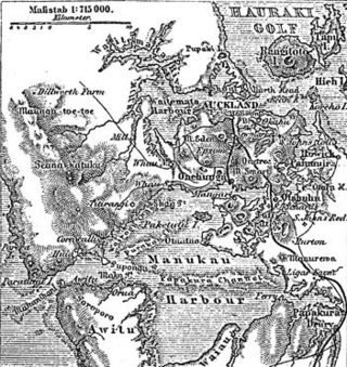
The Auckland isthmus, also known as the Tāmaki isthmus, is a narrow stretch of land on the North Island of New Zealand in the Auckland Region, and the location of the central suburbs of the city of Auckland, including the CBD. The isthmus is located between two rias : the Waitematā Harbour to the north, which opens to the Hauraki Gulf / Tīkapa Moana and Pacific Ocean, and the Manukau Harbour to the south, which opens to the Tasman Sea. The isthmus is the most southern section of the Northland Peninsula.

<span class="mw-page-title-main">History of Auckland</span> History of the city of Auckland, New Zealand

The human history of the Auckland metropolitan area stretches from early Māori settlers in the 14th century to the first European explorers in the late 18th century, over a short stretch as the official capital of (European-settled) New Zealand in the middle of the 19th century to its current position as the fastest-growing and commercially dominating metropolis of the country.

<span class="mw-page-title-main">Commercial Bay</span> Waterfront feature in Auckland, New Zealand

Commercial Bay was a bay on the southern side of the Waitematā Harbour that defined the original extent of the Auckland waterfront in Auckland, New Zealand.

<span class="mw-page-title-main">Auckland CBD</span> Central business district in Auckland Council, New Zealand

The Auckland Central Business District (CBD), or Auckland city centre, is the geographical and economic heart of the Auckland metropolitan area. It is the area in which Auckland was established in 1840, by William Hobson on land gifted by mana whenuahapū Ngāti Whātua Ōrākei. It is New Zealand's leading financial hub, and the centre of the country's economy; the GDP of the Auckland Region was NZD$139 billion in the year ending September 2023.

<span class="mw-page-title-main">Point Britomart</span>

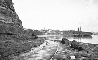
Point Britomart was a headland in the Waitematā Harbour, in Auckland, New Zealand. Located between Commercial Bay and Official Bay, the point was later quarried away to produce fill for land reclamation in Mechanics Bay, and almost no physical trace remains at street level in what is today an area of the Auckland CBD and the Auckland waterfront.

<span class="mw-page-title-main">Achilles Point</span>

Achilles Point is a rocky point on the headland at the eastern end of the small sandy beach named Ladies Bay, Auckland, New Zealand. The name 'Te Pane o Horoiwi' can also sometimes refer to the whole headland between St Heliers and Tamaki River estuary. Achilles Point is named after a ship called HMNZS Achilles (70) which defeated the German pocket battleship Admiral Graf Spee in 1939. The headland, from the point round to the Tamaki heads, was previously known as Te Pane o Horoiwi, named after Horoiwi who arrived in New Zealand on the Tainui canoe (waka).

<span class="mw-page-title-main">Tamaki Drive</span> Road in New Zealand

Tamaki Drive is the coastal road which follows the contours of the Waitematā Harbour, Auckland, New Zealand. The road links the suburbs Ōrākei, Mission Bay, and Kohimarama ending in Saint Heliers providing easy access to the local beaches. Tamaki Drive was completed in 1932 and incorporates The Strand, Bice Esplanade and, what was once part of the old Kohimarama Road. It is also referred to as the Waterfront Road. Tamaki Drive is a flat road around 8 km long and popular with walkers, runners and roller skaters, and includes a dedicated cycle lane. Those travelling along Tamaki Drive can find scenic highlights and peaceful views across the harbour to the volcanic island Rangitoto. The cliffs backing onto Tamaki Drive are made of Waitematā Sandstone strata clothed in places with pōhutukawa. These trees seem to flower out of season, because these are actually Kermadec pōhutukawa with small distinctive roundish leaves.

<span class="mw-page-title-main">West Auckland, New Zealand</span> Region of Auckland, New Zealand

West Auckland is one of the major geographical areas of Auckland, the largest city in New Zealand. Much of the area is dominated by the Waitākere Ranges, the eastern slopes of the Miocene era Waitākere volcano which was upraised from the ocean floor, and now one of the largest regional parks in New Zealand. The metropolitan area of West Auckland developed between the Waitākere Ranges to the west and the upper reaches of the Waitematā Harbour to the east. It covers areas such as Glen Eden, Henderson, Massey and New Lynn.

<span class="mw-page-title-main">Portages of New Zealand</span>

Portages in New Zealand, known in Māori as or Tōanga Waka, are locations where waka (canoes) could easily be transported overland. Portages were extremely important for early Māori, especially along the narrow Tāmaki isthmus of modern-day Auckland, as they served as crucial transportation and trade links between the east and west coasts. Portages can be found across New Zealand, especially in the narrow Northland and Auckland regions, and the rivers of the Waikato Region.

<span class="mw-page-title-main">Shoal Bay, New Zealand</span>

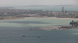
Shoal Bay is a bay of the Waitematā Harbour in Auckland, New Zealand. It is located on the North Shore.

References

  1. Campbell, Dr Nerida; Truttman, Lisa; Auckland City Council; Ngāti Pāoa; Ngāti Whātua-o-Ōrākei. "Auckland's Original Shoreline" (PDF). Auckland Council . Retrieved 24 September 2021.
  2. Mackintosh, Lucy (2021). Shifting Grounds: Deep Histories of Tāmaki Makaurau Auckland. Bridget Williams Books. p. 68. doi:10.7810/9781988587332. ISBN   978-1-988587-33-2.
  3. "New Zealand's first international airport". Auckland Museum.
  4. "Two people rescued after chopper loses power in Auckland and another helicopter crashes in Siberia". News AU. 7 May 2013.
  5. "Helicopter Me".

36°50′51″S174°47′07″E / 36.847631°S 174.785149°E / -36.847631; 174.785149