Ngāti Whātua is a Māori iwi (tribe) of the lower Northland Peninsula of New Zealand's North Island. It comprises a confederation of four hapū (subtribes) interconnected both by ancestry and by association over time: Te Uri-o-Hau, Te Roroa, Te Taoū, and Ngāti Whātua-o-Ōrākei. The four hapū can act together or separately as independent tribes.

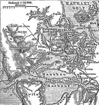
Waitematā Harbour is the main access by sea to Auckland, New Zealand. For this reason it is often referred to as Auckland Harbour, despite the fact that it is one of two harbours adjoining the city. The harbour forms the northern and eastern coasts of the Auckland isthmus and is crossed by the Auckland Harbour Bridge. It is matched on the southern side of the city by the shallower waters of the Manukau Harbour.
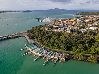
Ōrākei is a suburb of Auckland city, in the North Island of New Zealand. It is located on a peninsula five kilometres to the east of the city centre, on the shore of the Waitematā Harbour, which lies to the north, and Hobson Bay and Ōrākei Basin, two arms of the Waitematā, which lie to the west and south. To the east is the suburb of Mission Bay. Takaparawhau / Bastion Point is a coastal piece of land in Ōrākei. Between Takaparawhau and Paritai Drive is Ōkahu Bay and Reserve.

Māngere is a major suburb in South Auckland, New Zealand, located on mainly flat land on the northeastern shore of the Manukau Harbour, to the northwest of Manukau City Centre and 15 kilometres south of the Auckland city centre. It is the location of Auckland Airport, which lies close to the harbour's edge to the south of the suburb.

Greenhithe is a northwestern suburb of Auckland, New Zealand, located on the North Shore. Greenhithe was the location of Tauhinu, a fortified Te Kawerau ā Maki and Ngāti Whātua pā which overlooked the entrance to Oruamo or Hellyers Creek, that was settled until the 1820s. In the 1860s, the Forgham family established a community at Greenhithe, which by the 1880s had become a major fruit producer for Auckland. Boat repair and construction became major industries in Greenhithe in the 1960s.

Māngere Bridge is a suburb of Auckland, New Zealand, under the local governance of the Auckland Council. Surrounded by the Manukau Harbour, the area is the most north-western suburb of South Auckland, and is connected to Onehunga in central Auckland by three bridges that cross the Māngere Inlet. Many features of the Auckland volcanic field are found in and around Māngere Bridge, including Māngere Mountain, a 106-metre-high (348 ft) feature in the centre of the suburb, and Māngere Lagoon, a volcanic tidal lagoon opposite Puketutu Island in the harbour. The suburb is also home to Ambury Regional Park, a working farm and nature sanctuary run by Auckland Council, that connects to the Kiwi Esplanade and Watercare Coastal walkways.
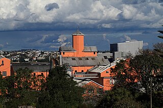
Chatswood is a suburb in the city of Auckland, New Zealand, in the middle-eastern side of North Shore. It contains a primary school and many parks. To the south of Chatswood is Kendall's Bay, a small bay of the Waitematā Harbour. The suburb is under the governance of Auckland Council. The Royal New Zealand Navy's Kauri Point Armament Depot is located in Chatswood. Chelsea Sugar Refinery is located in Chatswood.

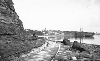
Takaparawhau / Bastion Point is a coastal piece of land in Ōrākei, Auckland, New Zealand, overlooking the Waitematā Harbour. The area is significant in New Zealand history as the site of protests in the late 1970s by Māori against forced land alienation by Pākehā. Takaparawhau is now the site of the private Ōrākei Marae, the public Michael Joseph Savage Memorial, and privately-owned reserve land that is accessible to the public.

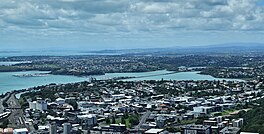
The Auckland isthmus, also known as the Tāmaki isthmus, is a narrow stretch of land on the North Island of New Zealand in the Auckland Region, and the location of the central suburbs of the city of Auckland, including the CBD. The isthmus is located between two rias : the Waitematā Harbour to the north, which opens to the Hauraki Gulf / Tīkapa Moana and Pacific Ocean, and the Manukau Harbour to the south, which opens to the Tasman Sea. The isthmus is the most southern section of the Northland Peninsula.
The human history of the Auckland metropolitan area stretches from early Māori settlers in the 14th century to the first European explorers in the late 18th century, over a short stretch as the official capital of (European-settled) New Zealand in the middle of the 19th century to its current position as the fastest-growing and commercially dominating metropolis of the country.
Point Britomart was a headland in the Waitematā Harbour, in Auckland, New Zealand. Located between Commercial Bay and Official Bay, the point was later quarried away to produce fill for land reclamation in Mechanics Bay, and almost no physical trace remains at street level in what is today an area of the Auckland CBD and the Auckland waterfront.

Apihai Te Kawau was a paramount chief of the Ngāti Whātua Māori iwi (tribe) of Auckland, New Zealand in the 19th century.

Tamaki Drive is the coastal road which follows the contours of the Waitematā Harbour, Auckland, New Zealand. The road links the suburbs Ōrākei, Mission Bay, and Kohimarama ending in Saint Heliers providing easy access to the local beaches. Tamaki Drive was completed in 1932 and incorporates The Strand, Bice Esplanade and, what was once part of the old Kohimarama Road. It is also referred to as the Waterfront Road. Tamaki Drive is a flat road around 8 km long and popular with walkers, runners and roller skaters, and includes a dedicated cycle lane. Those travelling along Tamaki Drive can find scenic highlights and peaceful views across the harbour to the volcanic island Rangitoto. The cliffs backing onto Tamaki Drive are made of Waitematā Sandstone strata clothed in places with pōhutukawa. These trees seem to flower out of season, because these are actually Kermadec pōhutukawa with small distinctive roundish leaves.

Ngāti Whātua Ōrākei or Ngāti Whātua-o-Ōrākei is an Auckland-based Māori hapū (sub-tribe) in New Zealand. Together with Te Uri-o-Hau, Te Roroa and Te Taoū, it comprises the iwi (tribe) of Ngāti Whātua. These four hapū can act together or separately as independent tribes. The hapū's rohe is mostly in Tāmaki Makaurau, the site of present-day Auckland. Ngāti Whātua Ōrākei has around 6,000 members whose collective affairs are managed by the Ngāti Whātua Ōrākei Trust.

Te Ākitai Waiohua is a Māori iwi of the southern part of the Auckland Region of New Zealand.

Tāmaki Māori are Māori iwi and hapū who have a strong connection to Tāmaki Makaurau, and whose rohe was traditionally within the region. Among Ngā Mana Whenua o Tāmaki Makaurau, also known as the Tāmaki Collective, there are thirteen iwi and hapū, organised into three rōpū (collectives), however Tāmaki Māori can also refer to subtribes and historical iwi not included in this list.

Te Waiohua or Te Wai-o-Hua is a Māori iwi (tribe) confederation that thrived in the early 18th century. The iwi's rohe was primarily the central Tāmaki Makaurau area and the Māngere peninsula, until the 1740s when the paramount chief Kiwi Tāmaki was defeated by the Ngāti Whātua hapū Te Taoū. The descendants of the Waiohua confederation today include Ngāti Te Ata Waiohua, Te Ākitai Waiohua, Ngā Oho of Ngāti Whātua Ōrākei and Tainui.
Kiwi Tāmaki was a Māori warrior and paramount chief of the Waiohua confederation in Tāmaki Makaurau. The third generation paramount chief of Waiohua, Kiwi Tāmaki consolidated and extended Waiohua power over Tāmaki Makaurau, making it one of the most prosperous and populated areas of Aotearoa. Kiwi Tāmaki's seat of power was at Maungakiekie, which was the most elaborate pā complex in Aotearoa.
Ngā Oho, also known as Ngā Ohomatakamokamo-o-Ohomairangi, is the name of a historical iwi (tribe) of Māori who settled in the Auckland Region. In the 17th century, Ngā Oho and two other tribes of shared heritage, Ngā Riki and Ngā Iwi, formed the Waiohua confederation of tribes.

Portages in New Zealand, known in Māori as Tō or Tōanga Waka, are locations where waka (canoes) could easily be transported overland. Portages were extremely important for early Māori, especially along the narrow Tāmaki isthmus of modern-day Auckland, as they served as crucial transportation and trade links between the east and west coasts. Portages can be found across New Zealand, especially in the narrow Northland and Auckland regions, and the rivers of the Waikato Region.