Eastern Transport Corridor

Last updated

The Eastern Transport Corridor, from above Saint Johns. Eastern Suburbs Railway Line Corridor.jpg
The Eastern Transport Corridor, from above Saint Johns.
Eastern Transport Corridor
The Eastern Transport Corridor. The green section is now Te Ara ki Uta ki Tai. The blue section is now Te Horeta Road. The red section will eventually become a 4-lane extension of Te Horeta Road{{cite book|title=Application under the COVID-19 Recovery (Fast-Track Consenting) Act 2020)|date=2022-07-29|publisher=Shundi Tāmaki Village Limited|pages=29|url=https://www.epa.govt.nz/assets/Uploads/Documents/Fast-track-consenting/Te-Tauoma-/Application-documents/Te-Tauoma-Stage-1B-Planning-Report-Final-to-EPA-290722.pdf |access-date=2023-04-09}}

The Eastern Transport Corridor in Auckland, New Zealand, is a transport reserve along a strip of land and water some of which is occupied by housing, commerce, industry and local roads. It runs adjacent to the North Island Main Trunk freight and passenger railway line.

Contents

Historically, it was to provide the route for an additional motorway connecting through the isthmus from the east into the Auckland CBD, with an estimated cost of up to $4 billion, [1] [2] but political and local community resistance made the project fail in the 2000s. As of 2022, Te Ara ki Uta ki Tai, a walking and cycling path between Glen Innes and Tāmaki Drive, is being built in this corridor; and the Eastern Busway is being built further south.

Proposed motorway

Original designs

A strategy study in 2002 stated a need for a new motorway to be built in the corridor (as had been planned decades before) for a variety of reasons including the need to make suburban streets safer and less polluted. In March 2004, Auckland City Mayor John Banks proposed a motorway scheme through Hobson Bay. There was substantial community and political resistance to the scheme, largely due to the cost of the proposal (equivalent to four years of the entire country's transport funding budget) and the impact it would have on a number of established neighbourhoods, as well as areas like Tamaki Drive, the Parnell Baths and several environmentally sensitive areas. [3] However, there were also groups that defended it, citing the projected economic gains, and the benefit it would have on the traffic volumes on Tamaki Drive.[ citation needed ] Banks proposed to underground large sections of the scheme (earning it the nickname 'tunnelway' amongst some commentators) and proposed to pay for the construction costs at least partly by selling Auckland City's 25% shareholding in Auckland International Airport, and by charging a $5 toll. [3] [4]

In 2002, Banks proposed that the Eastern Transport Corridor might link into a harbour tunnel starting north of Parnell, and linking to Ngataringa Bay near Devonport, for an estimated cost of $1 billion. [3]

Revised designs

Many spoke out against the project, including former Auckland City Mayor Christine Fletcher, who argued that the proposed motorway barely featured in the statutory policy documents, that city councillors lacked the necessary information to make informed decisions, and that the intended growth areas of the city would not require the corridor, with a public transport route being preferable. [5]

A revised plan published on 25 August 2004 reduced the number of lanes substantially (2-3 lanes + bus lane in each direction depending on the section), reducing the financial and ecological impact. Banks said he hoped the scheme would be acceptable to the opponents of the scheme, even though around 1,200 houses would still have to be demolished or otherwise affected. The Purewa Creek section was to be aligned on an elevated expressway to avoid damage to the environmentally sensitive area, while the motorway would be sunk into trenches in Glen Innes to reduce disruption. Depending on the connection to the CBD, the scheme would have either entered the city on a widened western Tamaki Drive section after crossing Hobson Bay, or gone through a tunnel under Parnell – which politicians promised would reduce much of the effects on Parnell residents. [6]

However the impacts were still high, and the costs rising (with a worst case estimate of NZ$3.9 billion), [2] and at that point the corridor was fast becoming a political boondoggle.

The proposed motorway was one of the principal points of contention in the 2004 local body elections and contributed to the defeat of Banks. It also led to the election of two candidates from the Action Hobson protest group who became councillors primarily on the promise to stop the new motorway. [7]

The Auckland City Council transport and urban linkages committee decided on 10 December 2004 to scrap the planned motorway component in favour of improved public transport and increased capacity on existing local roads.[ citation needed ] However the transport reserve remains in place, allowing for the motorway to be undertaken at some point in the future if it becomes economically and politically feasible.

Walking and cycling infrastructure

Auckland Transport and Waka Kotahi are building Te Ara Ki Uta Ki Tai (the path of land and sea) in this corridor. This will be built in four sections, from Glen Innes to Tāmaki Drive. The first 3 sections are open, and the last section is under construction as of 2022.

Alternative proposals

Based on this strong opposition to a major link through this area of eastern Auckland, the AMETI (Auckland-Manukau Eastern Transport Initiative) project was intended to improve the connections of this area towards the south-east (Manukau City), via less problematic routes. The new roads and public transport links were to serve intensified residential and mixed developments like the Mount Wellington Quarry area. [8] In 2010, it was revealed that the updated AMETI plans now included much stronger bus priority proposals than before. [9]

A significant part of AMETI emerged as the Eastern Busway project. Preliminary works for the busway began in 2018. [10]

The designations for the Eastern Transport Corridor still exist as of 2020, and is currently held by Auckland Transport. [11] Various proposals over the years (such as in 2006, initiated by Action Hobson) did not end in removal, partly because it was argued that the designations were needed for future proofing for the city's growth, and also because other transport links, such as another rail track, or busways, could be needed. [1]

Related Research Articles

<span class="mw-page-title-main">Panmure, New Zealand</span> Suburb in Auckland, New Zealand

Panmure is an east Auckland suburb, in the North Island of New Zealand. It is located 11 kilometres southeast of the Auckland CBD, close to the western banks of the Tāmaki River and the northern shore of the Panmure Basin. To the north lies the suburb of Tāmaki, and to the west is the cone of Maungarei / Mount Wellington.

Botany Town Centre is a large shopping mall and lifestyle centre located in Auckland, New Zealand. It has more than 200 stores spread across three complexes, including restaurants and entertainment buildings such as cinemas. It is situated at the corner of Ti Rakau Drive and Chapel Road in the suburb of East Tāmaki, and was opened in 2001.

<span class="mw-page-title-main">Māngere Bridge (bridges)</span> Bridge in New Zealand

Māngere Bridge, officially also called the Manukau Harbour Crossing, is a dual motorway bridge over the Manukau Harbour in south-western Auckland, New Zealand, crossing between the suburb also known as Māngere Bridge and the suburb of Onehunga.

<span class="mw-page-title-main">Glen Innes railway station</span> Railway station in New Zealand

Glen Innes railway station is located on the North Island Main Trunk line in New Zealand. Eastern Line services of the Auckland railway network are the only regular services that stop at the station. It has an island platform layout. Every hour it has at least three services towards Manukau and at least three towards Britomart. In 2006 the station had a major upgrade and is one of the most used non-terminus stations by the public.

<span class="mw-page-title-main">Central Motorway Junction</span> Road junction in New Zealand

The Central Motorway Junction or CMJ, is the intersection of State Highways 1 and 16, just south of the central business district of Auckland. A multilevel structure, it has been described as a "fiendishly complicated, multi-layered puzzle of concrete, steel and asphalt". Carrying around 200,000 vehicles a day, it is one of the busiest stretches of road in New Zealand.

<span class="mw-page-title-main">Northern Busway, Auckland</span> Busway in Auckland, New Zealand

The Northern Busway is a segregated busway that runs along the eastern side of the Northern Motorway, part of State Highway 1, in the north of Auckland, New Zealand, linking the North Shore with the northern end of the Auckland Harbour Bridge. As of May 2022, the busway consists of two-way lanes running between Albany Station and Akoranga Station, and from Akoranga Station a southbound-only lane that joins the harbour bridge approaches just south of the Onewa Road on-ramp system. Between 2008 and 2022 the busway terminated at Constellation.

Transport in Auckland, New Zealand's largest city, is defined by factors that include the shape of the Auckland isthmus, the suburban character of much of the urban area, a history of focusing investment on roading projects rather than public transport, and high car-ownership rates.

<span class="mw-page-title-main">Auckland isthmus</span> Narrow landstrip in Auckland, New Zealand

The Auckland isthmus, also known as the Tāmaki isthmus, is a narrow stretch of land on the North Island of New Zealand in the Auckland Region, and the location of the central suburbs of the city of Auckland, including the CBD. The isthmus is located between two rias, the Waitematā Harbour to the north, which opens to the Hauraki Gulf / Tīkapa Moana and Pacific Ocean, and the Manukau Harbour to the south, which opens to the Tasman Sea. The isthmus is the most southern section of the Northland Peninsula.

<span class="mw-page-title-main">Central Connector, Auckland</span>

The Central Connector, is a bus route between Britomart Transport Centre in the Auckland CBD, New Zealand, and the commercial suburb of Newmarket. It has some aspects of a bus rapid transit link. It was expected to improve journey times by about 14 minutes for around 2,600 buses per week, about 65,000 passengers daily. Work began in April 2008 and is now finished.

<span class="mw-page-title-main">Auckland Northern Motorway</span> Motorway located in Auckland, New Zealand

The Auckland Northern Motorway in the Auckland Region of New Zealand links Central Auckland and Puhoi in the former Rodney District via the Hibiscus Coast and North Shore. It is part of State Highway 1.

<span class="mw-page-title-main">Auckland Southern Motorway</span>

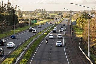
The Auckland Southern Motorway is the major route south out of the Auckland Region of New Zealand. It is part of State Highway 1.

<span class="mw-page-title-main">Public transport in Auckland</span> Information about public transit in Auckland

Public transport in Auckland, the largest metropolitan area of New Zealand, consists of three modes: bus, train and ferry. Services are coordinated by Auckland Transport under the AT Metro brand. Britomart Transport Centre is the main transport hub.

<span class="mw-page-title-main">Eastern Line (Auckland)</span> Railway service in Auckland

The Eastern Line is the name of the suburban rail service in Auckland, New Zealand between Britomart and Manukau via the North Island Main Trunk (NIMT) and Manukau Branch. Services are operated by Auckland One Rail under the Auckland Transport brand.

<span class="mw-page-title-main">Northwestern Cycleway</span>

The Northwestern Cycleway is a 12 km mostly off-road cycle route in New Zealand that connects the Auckland CBD with the suburb of Westgate. For most of its length, it runs alongside the Northwestern Motorway.

<span class="mw-page-title-main">Waikaraka Cycleway</span>

The Waikaraka Cycleway is an off-road cycleway in the south of the Auckland isthmus, New Zealand, running from the suburb of Wesley along New Zealand State Highway 20 to Onehunga and then continuing along the shoreline of the Manukau Harbour beside mostly industrialised areas until it ends at Hugo Johnston Drive, in Southdown.

The North Auckland and Northland (NAaN) grid upgrade project reinforced transmission into the Auckland Region and across the harbour to North Auckland and the Northland Region. It added new 220 kV transmission capacity to the National Grid by providing 37 km of underground cable between the Pakuranga, Penrose, and Albany substations.

<span class="mw-page-title-main">Auckland Airport Line</span>

The Auckland Airport Line was a proposed heavy rail line in Auckland, New Zealand, that would have linked Auckland Airport with the Auckland central business district via central isthmus suburbs.

<span class="mw-page-title-main">Eastern Busway, Auckland</span> Busway project that is under construction

The Eastern Busway, also known as AMETI, is Auckland's first urban busway under construction in the southeastern suburbs of Panmure, Pakuranga and Botany, in Auckland. The first section of the busway, between Panmure and Pakuranga, opened in December. The entire project is expected to be complete by 2026.

<span class="mw-page-title-main">Te Ara ki Uta ki Tai</span> Shared pathway connecting the suburbs of Ōrākei and Glen Innes in Auckland, New Zealand

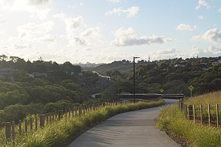
Te Ara ki Uta ki Tai, also known as the Glen Innes to Tāmaki Drive shared path, is a shared pathway connecting the suburbs of Ōrākei and Glen Innes in Auckland, New Zealand. It runs through the Pourewa Valley and the Eastern Transport Corridor, and for most of its length is adjacent to the North Island Main Trunk railway line.

<span class="mw-page-title-main">Hobson Bay</span>

Hobson Bay is a bay in the Auckland Region of New Zealand's North Island. It is located to the east of the Auckland City Centre, and is bisected by the Eastern Line and Tamaki Drive.

References

  1. 1 2 Dearnaley, Mathew (9 May 2006). "Outcry over bid to free up eastern highway land". The New Zealand Herald. Retrieved 23 December 2010.
  2. 1 2 "The $4b answer to traffic jams". The New Zealand Herald . 10 March 2004. Retrieved 4 January 2011.
  3. "Keith Rankin: Auckland Traffic Blues". 15 November 2001. Retrieved 30 December 2010.
  4. "Fletcher Submission to the Transport Committee". Press Release: Christine Fletcher. 29 June 2004. Retrieved 18 June 2011.
  5. "Parnell tunnel deserves every consideration". Press release: Auckland Citizens and Ratepayers Now. 10 March 2004. Retrieved 18 June 2011.
  6. Orsman, Bernard (12 October 2004). "Street protesters' fast road to power". The New Zealand Herald . Retrieved 23 December 2010.
  7. Auckland-Manukau Eastern transport initiative (AMETI) Archived 20 February 2007 at the Wayback Machine (from the Auckland City Council website)
  8. Dearnaley, Mathew (10 December 2010). "Fast track for buses in revised $1.3b plan". The New Zealand Herald . Retrieved 18 June 2011.
  9. "Work starting on next stage of $1.4 billion busway in east Auckland". The New Zealand Herald . 26 October 2018. Retrieved 7 December 2018.
  10. https://unitaryplan.aucklandcouncil.govt.nz/Images/Auckland%20Unitary%20Plan%20Operative/Chapter%20K%20Designations/Auckland%20Transport.pdf [ bare URL PDF ]