
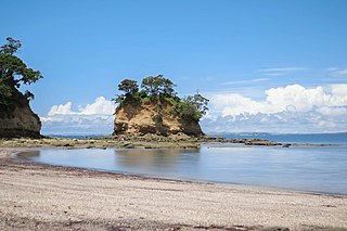
Onkaparinga River Recreation Park is a protected area occupying land in the estuary of the Onkaparinga River in South Australia. The recreation park which was established in 1985 is approximately 32 km (20 mi) from Adelaide city centre. It is the venue for recreational activities such as walking, canoeing, kayaking, recreational fishing and picnics.

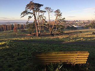
Remuera is an affluent suburb in East Auckland, New Zealand. It is located four kilometres southeast of the city centre. Remuera is characterised by many large houses, often Edwardian or mid 20th century. A prime example of a "leafy" suburb, Remuera is noted for its quiet tree lined streets. The suburb has numerous green spaces, most obvious of which is Ōhinerau / Mount Hobson – a volcanic cone with views from the top overlooking Waitematā Harbour and Rangitoto.

Ellerslie is a suburb of the city of Auckland, in the North Island of New Zealand. Ellerslie lies seven kilometres to the southeast of the city centre, close to State Highway 1.

Mission Bay is a seaside suburb of Auckland city, on the North Island of New Zealand. The suburb's beach is a popular resort, located alongside Tamaki Drive. The area also has a wide range of eateries. Mission Bay is located seven kilometres to the east of the city centre, on the southern shore of the Waitematā Harbour, between Ōrākei and Kohimarama. It covers an area of 1.08 km2, about three quarters of which comprises low hills, surrounding the remaining quarter, which slopes down to the sea. Local government of Mission Bay is the responsibility of the Ōrākei Local Board, which also includes the suburbs of Ōrākei, Kohimarama, St Heliers, Glendowie, St Johns, Meadowbank, Remuera and Ellerslie.

Bryndwr is a suburb in the north-west of Christchurch, New Zealand.

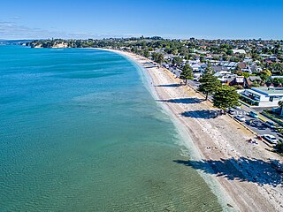
Browns Bay is one of the most northernmost suburbs in the contiguous Auckland metropolitan area, located in the North Shore. Named after the Brown family who settled here in 1876, Browns Bay became a holiday destination in the late 19th century. The area gradually developed into a suburb of Auckland in the 1950s, and was the administrative centre for the East Coast Bays City from 1975 until it was disestablished in 1989. During the 1990s, the suburb became a hub for the South African New Zealander community.
Torbay is a northern suburb of Auckland, New Zealand. It is located in the upper East Coast Bays of the city's North Shore, and is governed by Auckland Council.
Glendowie is a suburb in Auckland, New Zealand. It is under the local governance of Auckland Council. It was under Auckland City Council from 1989 until the merger of all of Auckland's councils into the "super city" in 2010.
Eastern Beach is a suburb of Auckland, New Zealand. Located on the eastern city of the city centre, the suburb is in the Howick ward, one of the thirteen administrative divisions of Auckland City. Its most common attraction is a popular white-sand palm fringed beach, also called Eastern Beach, with summer temperatures attracting thousands of people from neighbouring suburbs to the beach to enjoy the shallow waters, and shops and parks within close vicinity. At the southern end of the beach is a boat ramp giving high-medium tide access to the dedicated water skiing zone adjacent to the beach. This was a popular area for gathering Pipi and Cockles, but overuse has seen a rāhui or ban placed on the beach. It is part of the Bucklands Beach peninsula.

Lynfield is a suburb of Auckland, New Zealand. It is under the local governance of Auckland Council. The suburb is located on the southwestern Auckland isthmus bordering the Manukau Harbour, much of which is densely forested with native forest. Lynfield was developed for suburban housing in the late 1950s and 1960s, modelled after American-style suburbs.
Kohimarama is a coastal residential Auckland suburb, located to the east of the city. Kohimarama is situated between Mission Bay and St Heliers and has an accessible beach with a boardwalk and green recreational spaces located amongst residential areas. Local government of Kohimarama is the responsibility of the Ōrākei Local Board, which also includes the suburbs of Ōrākei, Mission Bay, St Heliers, Glendowie, St Johns, Meadowbank, Remuera and Ellerslie.
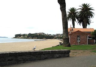
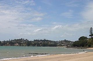
Saint Heliers is an affluent seaside suburb of Auckland with a population of 11,520 as of June 2022. This suburb is popular amongst visitors for the beaches, cafés, and views of Rangitoto Island, the distinctive volcanic island in the Hauraki Gulf.

Takaparawhau / Bastion Point is a coastal piece of land in Ōrākei, Auckland, New Zealand, overlooking the Waitematā Harbour. The area is significant in New Zealand history as the site of protests in the late 1970s by Māori against forced land alienation by Pākehā. Takaparawhau is now the site of the private Ōrākei Marae, the public Michael Joseph Savage Memorial, and privately-owned reserve land that is accessible to the public.

The Auckland isthmus, also known as the Tāmaki isthmus, is a narrow stretch of land on the North Island of New Zealand in the Auckland Region, and the location of the central suburbs of the city of Auckland, including the CBD. The isthmus is located between two rias : the Waitematā Harbour to the north, which opens to the Hauraki Gulf / Tīkapa Moana and Pacific Ocean, and the Manukau Harbour to the south, which opens to the Tasman Sea. The isthmus is the most southern section of the Northland Peninsula.

Avondale is a suburb of Auckland, New Zealand. Located on the central western Auckland isthmus. It is located in the Whau local board area, one of the 21 administrative divisions for the Auckland Council.
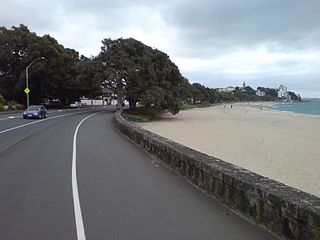
Tamaki Drive is the coastal road which follows the contours of the Waitematā Harbour, Auckland, New Zealand. The road links the suburbs Ōrākei, Mission Bay, and Kohimarama ending in Saint Heliers providing easy access to the local beaches. Tamaki Drive was completed in 1932 and incorporates The Strand, Bice Esplanade and, what was once part of the old Kohimarama Road. It is also referred to as the Waterfront Road. Tamaki Drive is a flat road around 8 km long and popular with walkers, runners and roller skaters, and includes a dedicated cycle lane. Those travelling along Tamaki Drive can find scenic highlights and peaceful views across the harbour to the volcanic island Rangitoto. The cliffs backing onto Tamaki Drive are made of Waitematā Sandstone strata clothed in places with pōhutukawa. These trees seem to flower out of season, because these are actually Kermadec pōhutukawa with small distinctive roundish leaves.
Burswood is a residential suburb of Auckland which is separated from the rest of the city by the Pakuranga Stream on its west, north and eastern sides, and the major road Ti Rakau Drive on its south. Population density is higher than in most of Auckland, with no quarter acre sections.
Ken Maunder Park, previously known as Rewa Park is a reserve and sports ground in the suburb of New Lynn in Auckland, New Zealand. It is the home ground of Lynn-Avon United and the Suburbs Cricket Club.

Ōrākei is a local government area in Auckland, in New Zealand's Auckland Region. It is governed by the Ōrākei Local Board and Auckland Council. It currently aligns with the council's Ōrākei Ward.

Parrs Park is a public recreational and sporting facility in Oratia, West Auckland, New Zealand. The park has lease arrangements with clubs and cultural organisations that have buildings and facilities on the perimeter and share the amenities of the park. The local community has a strong relationship with the park, organising and participating in events on the grounds, providing feedback to the council and voicing concerns. Parrs Park has been managed under a number of different Council structures since 1966 and as of 2022, is jointly governed by elected members of the Waitākere Ranges Local Board, as part of Auckland Council.

