
Greater Wellington, also known as the Wellington Region, is a non-unitary region of New Zealand that occupies the southernmost part of the North Island. The region covers an area of 8,049 square kilometres (3,108 sq mi), and has a population of 550,600.

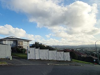
The North Shore is one of the major geographical regions of Auckland, the largest city in New Zealand. The area is defined as the northern shores of the Waitematā Harbour as far north as the Ōkura River.

The South Wairarapa District is a district at the south-east tip of the North Island of New Zealand, governed by the South Wairarapa District Council. The district comprises the southernmost part of the Wairarapa, and is part of the Wellington Region.

Mount Wellington is a suburb in East Auckland, New Zealand, located 10 km (6.2 mi) southeast of the city centre. It is surrounded by the suburbs of Stonefields, Tamaki, Panmure, Penrose, and Ellerslie, and by the Tāmaki River. The suburb is named after the volcanic peak of Maungarei / Mount Wellington. Sylvia Park is a large business park and shopping centre located in the suburb.

Horowhenua District is a territorial authority district on the west coast of the North Island of New Zealand, administered by Horowhenua District Council. Located north of Wellington and Kāpiti, it stretches from slightly north of the town of Ōtaki in the south to just south of Himatangi in the north, and from the coast to the top of the Tararua Range. It is in the Manawatū-Whanganui local government region. The name Horowhenua is Māori for landslide.

The Thames-Coromandel District is a territorial authority district in the North Island of New Zealand, covering all the Coromandel Peninsula and extending south to Hikutaia.

Hauraki District is a territorial authority governed by the Hauraki District Council within the Waikato region of New Zealand. The seat of the council is at Paeroa.

Central Otago District is local government district in New Zealand. It is administered by the Central Otago District Council, and it is in the Otago region, the top tier of local government in New Zealand. The major towns in the district are Alexandra, Cromwell, Roxburgh, Clyde and Ranfurly. The district covers 9,968 km2 (3,849 sq mi), making it the fourth-largest district in New Zealand by area, and is home to 26,500 people as of June 2024.

Westland District is a territorial authority district on the West Coast of New Zealand's South Island. It is administered by the Westland District Council. The district's population is 9,430.

Clutha District is a local government district of southern New Zealand, with its headquarters in the Otago town of Balclutha. Clutha District has a land area of 6,334.47 km2 (2,445.75 sq mi) and an estimated population of 19,300 as of June 2024. Clutha District occupies the majority of the geographical area known as South Otago.
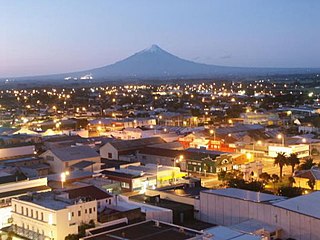
South Taranaki is a territorial authority on the west coast of New Zealand's North Island that contains the towns of Hāwera, Manaia, Ōpunake, Patea, Eltham, and Waverley. The District has a land area of 3,575.46 km2 and a population of 30,400. It is part of the greater Taranaki Region.
New Windsor, founded in 1865, is a suburb of Auckland, New Zealand. It is located 10 kilometres (6.2 mi) from the Auckland city centre, between Mount Albert, Blockhouse Bay, Mt Roskill and Avondale.

Forrest Hill is a suburb located on the North Shore of Auckland, New Zealand.
West Harbour is a suburb of Auckland, located to the west of the Auckland isthmus and CBD. It is named for its location on the western side of the Waitematā Harbour. West Harbour is under the governance of Auckland Council after the amalgamation of district councils in 2010.

Western Heights is a neighbourhood of Henderson, in West Auckland, New Zealand. Western Heights School and the nearby shops are the centre of the community. Western Heights is a "frontier suburb", separating suburban Auckland from lifestyle farming blocks, orchards and the Waitākere Ranges.

Massey is a northern suburb in West Auckland, New Zealand. It was formerly a northern suburb of Waitakere City, which existed from 1989 to 2010 before the city was amalgamated into Auckland Council. The suburb was named after former Prime Minister of New Zealand William Massey. Massey is a relatively large suburb and can be divided into three reasonably distinctive areas, Massey West, Massey East and Massey North. Parts of Massey East are also known as 'Royal Heights', which is home to the Royal Heights shopping centre.

Glendene is a suburb of West Auckland, in New Zealand. It is under the local governance of the Auckland Council.

Lincoln is a suburb in West Auckland, New Zealand. It is also the filming location of Shortland Street. The suburb is sometimes called Lincoln North or treated as part of Henderson North to avoid confusion with Lincoln in Canterbury.

Bayview is a suburb of Auckland in New Zealand. The area was included into the North Shore ward in 2010, one of the new thirteen administrative areas of the new Auckland Council.
Rānui is a suburb of West Auckland, New Zealand, which is under the local governance of Auckland Council. The area is densely populated but close to the western fringe of the Auckland urban area.


