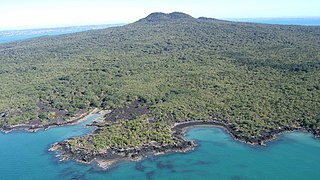
Rangitoto Island is a volcanic island in the Hauraki Gulf near Auckland, New Zealand. The 5.5 km (3.4 mi) wide island is a symmetrical shield volcano cone capped by central scoria cones, reaching a height of 260 m (850 ft). Rangitoto is the youngest and largest of the approximately 50 volcanoes of the Auckland volcanic field, having erupted in two phases about 620 and 600 years ago and covering an area of 2,311 ha. It is separated from the mainland of Auckland's North Shore by the Rangitoto Channel. Since World War II, it has been linked by a causeway to the much older, non-volcanic Motutapu Island.

The Kaimai Range is a mountain range in the North Island of New Zealand. It is part of a series of ranges, with the Coromandel Range to the north and the Mamaku Ranges to the south. The Kaimai Range separates the Waikato in the west from the Bay of Plenty in the east.
Epsom is a suburb of Auckland, New Zealand. It is located in the centre of the Auckland isthmus between Mount Eden and Greenlane, south of Newmarket, and five km south of Auckland CBD.

The New Zealand kākā is a large species of parrot of the family Nestoridae found in New Zealand's native forests. The species is often known by the abbreviated name kākā, although it shares this name with the recently extinct Norfolk kākā and Chatham kākā. Two subspecies of New Zealand kākā are recognised. It is endangered and has disappeared from much of its former range, though the re-introduction of North Island kākā at Zealandia in Wellington has led to an increasing population of the birds across the city.
The Waitākere Ranges is a mountain range in New Zealand. Located in West Auckland between metropolitan Auckland and the Tasman Sea, the ranges and its foothills and coasts comprise some 27,720 hectares of public and private land. The area, traditionally known to Māori as Te Wao Nui o Tiriwa, is of local, regional, and national significance. The Waitākere Ranges includes a chain of hills in the Auckland Region, generally running approximately 25 kilometres (16 mi) from north to south, 25 km west of central Auckland. The ranges are part of the Waitākere Ranges Regional Park.

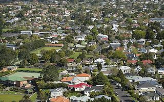
Remuera is an affluent suburb in East Auckland, New Zealand. It is located four kilometres southeast of the city centre. Remuera is characterised by many large houses, often Edwardian or mid 20th century. A prime example of a "leafy" suburb, Remuera is noted for its quiet tree lined streets. The suburb has numerous green spaces, most obvious of which is Ōhinerau / Mount Hobson – a volcanic cone with views from the top overlooking Waitematā Harbour and Rangitoto.
Parnell is a suburb of Auckland, New Zealand. It is one of New Zealand's most affluent suburbs, consistently ranked within the top three wealthiest, and is often billed as Auckland's "oldest suburb" since it dates from the earliest days of the European settlement of Auckland in 1841. It is characterised by its mix of tree lined streets with large estates; redeveloped industrial zones with Edwardian town houses and 1920s bay villas; and its hilly topography that allows for views of the port, the Waitematā Harbour, Rangitoto Island and the Auckland Domain. To its west lies the Auckland Domain, to the south Newmarket, and to the north the Ports of Auckland.
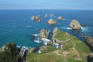
Nugget Point is one of the most iconic landforms on the Otago coast. Located at the northern end of the Catlins coast, along the road from Kaka Point, this steep headland has a lighthouse at its tip, surrounded by rocky islets. The point is home to many seabirds, including penguins, gannets and royal spoonbills, and a large breeding colony of fur seals. Roaring Bay, on the south coast of the tip of Nugget Point, is home to a small colony of yellow-eyed penguins.
Ruakākā is a small town in the north of New Zealand approximately 30 kilometres south of Whangārei in the Bream Bay area. Originally a small beachside community, Ruakākā has seen development due to its proximity to the expansion of the country's only oil refinery at Marsden Point during the 1980s. A recently established timber processing plant at Marsden Point has further stimulated growth.

Otari-Wilton's Bush is a native botanic garden and forest reserve located in Wilton in Wellington, New Zealand. It is the only public botanic garden that is dedicated solely to the native plants of New Zealand.

Waipātiki Beach is a small coastal village in the Hastings District and Hawke's Bay Region of New Zealand's North Island. It is situated in a little valley at the end of a road that branches off the main road from Napier to Gisborne and that finally, after 11 km, leads to a small sandy beach; first Tangoio Rd, then Waipātiki Road.

The New Zealand parrot family, Strigopidae, consists of at least three genera of parrots – Nestor, Strigops, the fossil Nelepsittacus, and probably the fossil Heracles. The genus Nestor consists of the kea, kākā, Norfolk kākā and Chatham kākā, while the genus Strigops contains the iconic kākāpō. All extant species are endemic to New Zealand. The species of the genus Nelepsittacus were endemics of the main islands, while the two extinct species of the genus Nestor were found at the nearby oceanic islands such as Chatham Island of New Zealand, and Norfolk Island and adjacent Phillip Island.

Long Bay Regional Park is a regional park in Long Bay located in Auckland, New Zealand. It is located in the Hibiscus and Bays in the northern part of the city and is operated by Auckland Council.

Ōwairaka / Mount Albert, also known as Te Ahi-kā-a-Rakataura, is a volcanic peak and Tūpuna Maunga which dominates the landscape of the Owairaka and Mount Albert suburbs of Auckland.
Wenderholm Regional Park is a regional park north of Auckland in New Zealand's North Island. It is situated between the estuaries of the Puhoi River and the Waiwera River, on the east coast of New Zealand's North Island and features a homestead known as Couldrey House, and a carved pouwhenua.

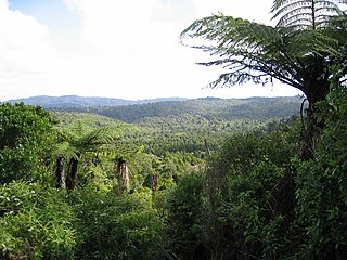
Pirongia Forest Park is a protected area 30 km southwest of Hamilton, New Zealand. It covers 167.7 square kilometres (64.7 sq mi) across four blocks of land - Pirongia, Te Maunga O Karioi Block, and the small Mangakino Block and Te Rauamoa Block. The park encompasses Mount Pirongia west of Pirongia and Mount Karioi near the coast southwest of Raglan.
Wairēinga / Bridal Veil Falls Scenic Reserve is also in the area, but is separate to Pirongia Forest Park.

Ngā Manu Nature Reserve is a nature and wildlife reserve in Waikanae, New Zealand, on the Kapiti Coast of the North Island. In addition to offering a sanctuary for native birds and other animals, the 14 hectares reserve preserves the largest remnant of coastal lowland swamp forest on the Kapiti Coast.
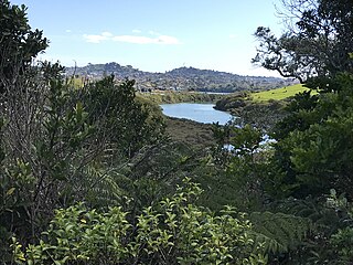
Kepa Bush Reserve is an ecological reserve on the Auckland isthmus in New Zealand, south of Mission Bay. It is situated near the smaller St John's Bush and is also known as the Pourewa Valley.

Tāwharanui Regional Park is a regional park on the Tāwharanui Peninsula in the Auckland Region of New Zealand's North Island. It is located in Rodney, east of Warkworth and north of Auckland.

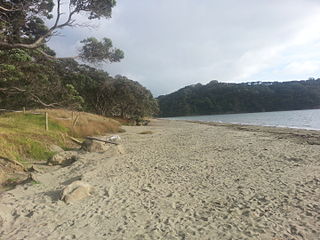
Te Matuku Marine Reserve is a marine reserve administered by the New Zealand Department of Conservation. It includes Te Matuku Bay, one of the largest and least disturbed estuaries on Waiheke Island, as well as a surrounding area of sea. It covers an area of 690 ha and was established in 2003.


