Meadowbank, New Zealand

Last updated

Meadowbank
Akldmeadowbank01.png
Ōrākei Creek in Meadowbank, as seen from the Waiatarua Road overbridge
Meadowbank, New Zealand
Coordinates: 36°52′19″S174°49′37″E / 36.871924°S 174.826907°E / -36.871924; 174.826907
CountryNew Zealand
City Auckland
Local authority Auckland Council
Electoral ward Ōrākei ward
Local board Ōrākei Local Board
Area
[1]
  Land169 ha (418 acres)
Population
 (June 2022) [2]
  Total5,470
Postcode(s)
1072
Train station(s) Meadowbank Railway Station
Parnell (3.9 km) Ōrākei (1.6 km) Mission Bay (2.0 km)
Remuera (2.2 km)
Pfeil oben.svg
Pfeil links.svgMeadowbankPfeil rechts.svg
Pfeil unten.svg
Glen Innes (3.6 km)
Greenlane (3.6 km) Ellerslie (3.2 km) St Johns (1.9 km)

Meadowbank is a suburb of Auckland city, situated in the North Island of New Zealand. Meadowbank is governed under the local governance of the Auckland Council. It has one shopping centre: Meadowbank Shopping Centre, on the corner of Gerard Way and St John's Road. Purewa Cemetery, one of central Auckland's largest cemeteries, is situated in Meadowbank and can be accessed from St John's Road.

Contents

History

In 1930, an extension of the Remuera electric tramway was opened, servicing Meadowbank. [3]

Demographics

Meadowbank covers 1.69 km2 (0.65 sq mi) [1] and had an estimated population of 5,470 as of June 2022, [2] with a population density of 3,237 people per km2.

Historical population
YearPop.±% p.a.
20064,695    
20135,049+1.04%
20185,328+1.08%
Source: [4]

Meadowbank had a population of 5,328 at the 2018 New Zealand census, an increase of 279 people (5.5%) since the 2013 census, and an increase of 633 people (13.5%) since the 2006 census. There were 1,947 households, comprising 2,499 males and 2,829 females, giving a sex ratio of 0.88 males per female, with 1,188 people (22.3%) aged under 15 years, 840 (15.8%) aged 15 to 29, 2,619 (49.2%) aged 30 to 64, and 684 (12.8%) aged 65 or older.

Ethnicities were 76.5% European/Pākehā, 6.2% Māori, 4.8% Pacific peoples, 16.8% Asian, and 4.1% other ethnicities. People may identify with more than one ethnicity.

The percentage of people born overseas was 33.8, compared with 27.1% nationally.

Although some people chose not to answer the census's question about religious affiliation, 44.3% had no religion, 43.2% were Christian, 0.3% had Māori religious beliefs, 1.5% were Hindu, 1.3% were Muslim, 1.6% were Buddhist and 2.7% had other religions.

Of those at least 15 years old, 1,914 (46.2%) people had a bachelor's or higher degree, and 291 (7.0%) people had no formal qualifications. 1,449 people (35.0%) earned over $70,000 compared to 17.2% nationally. The employment status of those at least 15 was that 2,325 (56.2%) people were employed full-time, 600 (14.5%) were part-time, and 138 (3.3%) were unemployed. [4]

Individual statistical areas
NameArea (km2)PopulationDensity (per km2)HouseholdsMedian ageMedian income
Meadowbank West1.042,7302,62594837.9 years$47,400 [5]
Meadowbank East0.652,5983,99799937.8 years$50,800 [6]
New Zealand37.4 years$31,800

Education

St John's College and Trinity Theological College are also located on St John's Road. Local primary schools include Meadowbank School (public) and Mt Carmel School, Meadowbank (state-integrated Catholic). Local secondary schools comprise Selwyn College and Baradene College of the Sacred Heart. Mount Carmel School is a coeducational state-integrated Catholic primary school (years 1–6) with a roll of 224 as of April 2023. [7] [8]

Related Research Articles

<span class="mw-page-title-main">Newmarket, New Zealand</span> Suburb in Auckland, New Zealand

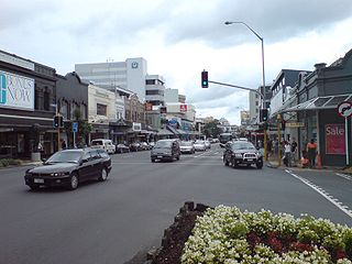
Newmarket is an Auckland suburb to the south-east of the central business district. With its high building density, especially of retail shops, it is considered New Zealand's premier retailing area, and a rival of local competitor Auckland CBD.

<span class="mw-page-title-main">Drury, New Zealand</span> Suburb in Auckland, New Zealand

Drury is a rural town near Auckland, in northern New Zealand. Located 36 kilometres to the south of Auckland CBD, under authority of the Auckland Council. Drury lies at the southern border of the Auckland metropolitan area, 12 kilometres to the northeast of Pukekohe, close to the Papakura Channel, an arm of the Manukau Harbour.

<span class="mw-page-title-main">Epsom, New Zealand</span> Suburb in Auckland, New Zealand

Epsom is a suburb of Auckland, New Zealand. It is located in the centre of the Auckland isthmus between Mount Eden and Greenlane, south of Newmarket, and five km south of Auckland CBD.

<span class="mw-page-title-main">Remuera</span> Suburb in Auckland, New Zealand

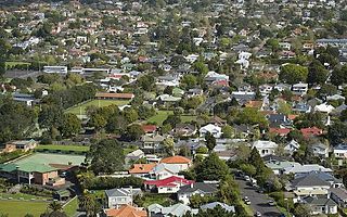
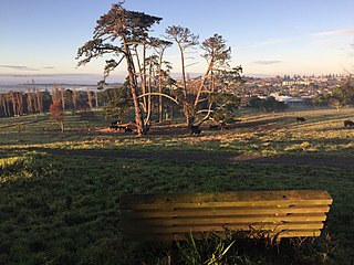
Remuera is an affluent suburb in East Auckland, New Zealand. It is located four kilometres southeast of the city centre. Remuera is characterised by many large houses, often Edwardian or mid 20th century. A prime example of a "leafy" suburb, Remuera is noted for its quiet tree lined streets. The suburb has numerous green spaces, most obvious of which is Ōhinerau / Mount Hobson – a volcanic cone with views from the top overlooking Waitematā Harbour and Rangitoto.

<span class="mw-page-title-main">Freemans Bay</span> Suburb in Auckland, New Zealand

Freemans Bay is the name of a former bay and now inner city suburb of Auckland, in the North Island of New Zealand. The bay has been filled in to a considerable extent, with the reclamation area now totally concealing the ancient shoreline. Historically a poor and often disreputable quarter, it is now a comparatively wealthy and desirable neighbourhood known for its mix of heritage homes and more recent single-dwelling houses, as well as for its two large parks.

<span class="mw-page-title-main">Ōrākei</span> Suburb of Auckland

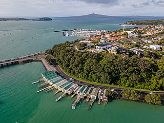
Ōrākei is a suburb of Auckland city, in the North Island of New Zealand. It is located on a peninsula five kilometres to the east of the city centre, on the shore of the Waitematā Harbour, which lies to the north, and Hobson Bay and Ōrākei Basin, two arms of the Waitematā, which lie to the west and south. To the east is the suburb of Mission Bay. Takaparawhau / Bastion Point is a coastal piece of land in Ōrākei. Between Takaparawhau and Paritai Drive is Ōkahu Bay and Reserve.

<span class="mw-page-title-main">Ellerslie, New Zealand</span> Suburb in Auckland, New Zealand

Ellerslie is a suburb of the city of Auckland, in the North Island of New Zealand. Ellerslie lies seven kilometres to the southeast of the city centre, close to State Highway 1.

<span class="mw-page-title-main">Glen Innes, New Zealand</span> Suburb in Auckland, New Zealand

Glen Innes is a suburb in East Auckland, New Zealand, located nine kilometres to the east of the city centre, close to the waters of the Tamaki River estuary.

<span class="mw-page-title-main">Milford, New Zealand</span> Suburb in Auckland, New Zealand

Milford is a suburb located on the North Shore, Auckland. It is located on northern side of Lake Pupuke. It also has a popular swimming beach, which runs some two kilometers from Black Rock in the south to Castor Bay in the north. The Wairau Creek reaches the sea at the Hauraki Gulf at the northern end of Milford Beach, and its lower tidal reaches host the Milford Marina.

<span class="mw-page-title-main">Mission Bay, New Zealand</span> Suburb in Auckland, New Zealand

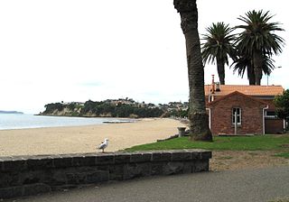
Mission Bay is a seaside suburb of Auckland city, on the North Island of New Zealand. The suburb's beach is a popular resort, located alongside Tamaki Drive. The area also has a wide range of eateries. Mission Bay is located seven kilometres to the east of the city centre, on the southern shore of the Waitematā Harbour, between Ōrākei and Kohimarama. It covers an area of 1.08 km2, about three quarters of which comprises low hills, surrounding the remaining quarter, which slopes down to the sea. Local government of Mission Bay is the responsibility of the Ōrākei Local Board, which also includes the suburbs of Ōrākei, Kohimarama, St Heliers, Glendowie, St Johns, Meadowbank, Remuera and Ellerslie.

<span class="mw-page-title-main">Kelston, New Zealand</span> Suburb in Auckland, New Zealand

Kelston is a residential suburb of West Auckland, New Zealand. Originally a ceramics manufacturing centre, the area is now mostly residential, including a number of schools. Kelston is located in, and its name has been given to, the Kelston parliamentary electorate.

<span class="mw-page-title-main">Mairangi Bay</span> Suburb in Auckland, New Zealand

Mairangi Bay is a coastal suburb of North Shore, Auckland, located in the northern North Island of New Zealand, on the south-east-facing peninsula forming the northern side of the Waitematā Harbour. Mairangi Bay came under the local governance of the North Shore City Council until subsumed into the Auckland Council in 2010.

<span class="mw-page-title-main">Glendowie, New Zealand</span> Suburb in Auckland, New Zealand

Glendowie is a suburb in Auckland, New Zealand. It is under the local governance of Auckland Council. It was under Auckland City Council from 1989 until the merger of all of Auckland's councils into the "super city" in 2010.

<span class="mw-page-title-main">Greenlane</span> Suburb in Auckland, New Zealand

Greenlane is a central isthmus suburb in Auckland, New Zealand. It is bounded by Epsom to the west, Newmarket to the north, Remuera to the east and One Tree Hill to the south.

<span class="mw-page-title-main">Kohimarama</span> Suburb in Auckland, New Zealand

Kohimarama is a coastal residential Auckland suburb, located to the east of the city. Kohimarama is situated between Mission Bay and St Heliers and has an accessible beach with a boardwalk and green recreational spaces located amongst residential areas. Local government of Kohimarama is the responsibility of the Ōrākei Local Board, which also includes the suburbs of Ōrākei, Mission Bay, St Heliers, Glendowie, St Johns, Meadowbank, Remuera and Ellerslie.

<span class="mw-page-title-main">St Johns, New Zealand</span> Suburb in Auckland, New Zealand

St Johns is a suburb in Auckland, New Zealand.

<span class="mw-page-title-main">Saint Heliers</span> Suburb in Auckland, New Zealand

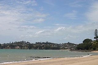
Saint Heliers is an affluent seaside suburb of Auckland with a population of 11,520 as of June 2022. This suburb is popular amongst visitors for the beaches, cafés, and views of Rangitoto Island, the distinctive volcanic island in the Hauraki Gulf.

<span class="mw-page-title-main">Glendene, New Zealand</span> Suburb in Auckland, New Zealand

Glendene is a suburb of West Auckland, in New Zealand. It is under the local governance of the Auckland Council.

<span class="mw-page-title-main">Fitzroy, New Plymouth</span> Suburb of New Plymouth, New Zealand

Fitzroy is a coastal suburb of New Plymouth, in the western North Island of New Zealand. It is located to the north-east of the city centre.

<span class="mw-page-title-main">Ōrākei ward</span> Ward of Auckland in New Zealand

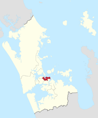
Ōrākei Ward is one of thirteen wards of Auckland Council in Auckland, New Zealand. It encompasses the neighbourhoods of Saint Heliers, Glendowie, Kohimarama, Mission Bay, Saint Johns and Meadowbank. It elects one councillor to represent the ward on the council. The councillor has oversight over the Orakei Local Board. The current councillor is Desley Simpson.

References

  1. 1 2 "ArcGIS Web Application". statsnz.maps.arcgis.com. Retrieved 18 July 2022.
  2. 1 2 "Population estimate tables - NZ.Stat". Statistics New Zealand . Retrieved 25 October 2022.
  3. "TRAM EXTENSION AT REMUERA OPENED". Auckland Sun . Papers Past. 9 June 1930. p. 16. Retrieved 31 August 2021.
  4. 1 2 "Statistical area 1 dataset for 2018 Census". Statistics New Zealand. March 2020. Meadowbank West (141900) and Meadowbank East (143200).
  5. 2018 Census place summary: Meadowbank West
  6. 2018 Census place summary: Meadowbank East
  7. "New Zealand Schools Directory". New Zealand Ministry of Education. Retrieved 12 December 2022.
  8. Education Counts: Mount Carmel School