
Fiordland is a geographical region of New Zealand in the south-western corner of the South Island, comprising the westernmost third of Southland. Most of Fiordland is dominated by the steep sides of the snow-capped Southern Alps, deep lakes, and its steep, glacier-carved and now ocean-flooded western valleys. The name "Fiordland" comes from a variant spelling of the Scandinavian word for this type of steep valley, "fjord". The area of Fiordland is dominated by, and very roughly coterminous with, Fiordland National Park, New Zealand's largest National Park.

Fiordland National Park is a national park in the south-west corner of South Island of New Zealand. It is the largest of the 13 national parks in New Zealand, with an area covering 12,607 km2 (4,868 sq mi), and a major part of the Te Wāhipounamu a UNESCO World Heritage Site established in 1990. The park is administered by the Department of Conservation. The southern ranges of the Southern Alps cover most of Fiordland National Park, combined with the deep glacier-carved valleys.

Lake Manapouri is located in the South Island of New Zealand. The lake is situated within the Fiordland National Park and the wider region of Te Wahipounamu South West New Zealand World Heritage Area.

Manapouri is a small town in Southland / Fiordland, in the southwest corner of the South Island, in New Zealand. The township is the westernmost municipality in New Zealand. Located at the edge of the Fiordland National Park, on the eastern shore of Lake Manapouri, close to its outflow into the Waiau River, tourist boat services are based in the town.
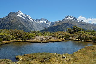
The Routeburn Track is a world-renowned, 32 km tramping (hiking) track found in the South Island of New Zealand. The track can be done in either direction, starting on the Queenstown side of the Southern Alps, at the northern end of Lake Wakatipu or on the Te Anau side, at the Divide, several kilometres from the Homer Tunnel to Milford Sound.

The Dobson River is a river in the South Island of New Zealand. It flows south between the Neumann and Ohau ranges for 45 kilometres (28 mi) from its source to the east of Mount Hopkins, in the Southern Alps, before joining with the Hopkins River, close to the latter's entry into the northern end of Lake Ōhau in the Mackenzie Country. The river flows over wide shingle beds, and has no rapids of interest to whitewater enthusiasts. It was named by Julius von Haast in the 1860s for his father-in-law, Edward Dobson, who was the Canterbury Provincial Engineer. The Māori name, also given as Otao in some works, means "driftwood," and has also been applied to the Hopkins River into which the Dobson/Ōtaao flows.

Lake Monowai is a large lake in the southern part of Fiordland National Park, in New Zealand's South Island, 120 kilometres northwest of Invercargill. At an altitude of 180 metres in a long curved valley, the lake appears on maps shaped like a letter "U". The western part of the lake is set in beautiful mountainous country. It is drained in the northeast by the short Monowai River, which enters the Waiau River eight kilometres to the northeast.

The Hollyford Track is a tramping track in New Zealand. Located at the northern edge of Fiordland, in the southwestern South Island, it is unusual among Fiordland's major tracks in that it is largely flat and accessible year-round. It follows the Hollyford River which in turn follows the course of the Hollyford Valley.

The Matiri River is a river located in the northwest of New Zealand's South Island. The river is in the Tasman Region.

The Tararua Range, often referred to as the Tararua Ranges or Tararua, is one of several mountain ranges in the North Island of New Zealand.

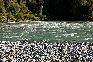
The Waiau River is the largest river in the Southland region of New Zealand. 'Waiau' translates to 'River of Swirling Currents'. It is the outflow of Lake Te Anau, flowing from it into Lake Manapouri 10 kilometres (6 mi) to the south, and from there flows south for 70 kilometres (43 mi) before reaching the Foveaux Strait 8 kilometres (5 mi) south of Tuatapere. It also takes water from Lake Monowai.

The Kepler Track is a 60 km (37 mi) circular hiking track which travels through the landscape of the South Island of New Zealand and is situated near the town of Te Anau. The track passes through many landscapes of the Fiordland National Park such as rocky mountain ridges, tall mossy forests, lake shores, deep gorges, rare wetlands and rivers. Like the mountains it traverses, the track is named after Johannes Kepler. The track is one of the New Zealand Great Walks and is administered by the Department of Conservation (DOC).

The Perth River is a river in the Southern Alps in the West Coast region of New Zealand's South Island. Its source is in terrace icefields north of the Rangitata Divide and is joined by multiple tributaries, including a creek from Abel Lake. It features a number of rapids and passes through two gorges before meeting the Whataroa River. The river is largely inaccessible, but recently, an adventure tourism company has begun offering "heli-rafting" on the river: whitewater rafters are flown in by helicopter to raft the river.
The Mōkihinui River is a river located on the West Coast of New Zealand's South Island, about 40 kilometres north of Westport. Meridian Energy had proposed the Mokihinui Hydro project on the river in 2007 but it was cancelled in May 2012. In 2019, it was announced that 64,400 ha of land in the Mōkihinui River catchment, including 15 km (9.3 mi) of river bed, would be added to Kahurangi National Park.

Craigieburn Forest Park is a protected area in the South Island of New Zealand, adjacent to Arthur's Pass National Park to the north.

The Wilmot Pass is a 671 m (2,201 ft) high pass on the main divide of New Zealand's South Island. It connects Doubtful Sound, a deep indentation in the coast of Fiordland, to the valley of the West Arm of Lake Manapouri. The pass is named after E. H. Wilmot, a former surveyor-general of New Zealand, who had noted it while surveying the area in 1897. It lies between Mount Wilmot and Mount Mainwaring. On the east side the Spey River drains to Lake Manapouri and on the west side the Lyvia River drains to Deep Cove.

The Hunter Mountains of Fiordland, New Zealand, were named by surveyor James McKerrow after the famous anatomist John Hunter. The Hunter Mountain Range covers an area between The South Arm and Hope Arm of Lake Manapouri south to the Green Lake.

The Doubtful River is a river in the Canterbury region of New Zealand. It rises near Mount Barron and flows south then south-east through Lake Sumner Forest Park, reaching the Boyle River 40 kilometres (25 mi) west of Hanmer Springs. The Doubtful Range lies to the south. The Doubtless River and Devilskin Stream are tributaries entering from the north.

The Rees River is a headwater tributary of the Clutha River / Mata-Au that drains eastward of the main divide of the Southern Alps / Kā Tiritiri o te Moana in New Zealand. The river runs 41 km, drains an area of 406 km2, and discharges into the head of Lake Wakatipu at Glenorchy. Bound by the Richardson (Whakaari) Mountains to the east and the Forbes Mountains to the west, its snow-covered headwaters rise above 2000 m.
Green Lake is a lake in Hunter Mountains in the Southland Region of New Zealand located to the north of Lake Monowai. The lake has no surface outlets but probably feeds several streams draining to lake Monowai via springs. The lake is a basin in the debris of the Green Lake Landslide, which is the largest known above-sea-level landslide on earth. Steep escarpments on the north and east sides of the lake form the head scarp of the landslide, which has an estimated volume of 27 cubic kilometres (6.5 cu mi).


