Related Research Articles

The Tasman Sea is a marginal sea of the South Pacific Ocean, situated between Australia and New Zealand. It measures about 2,000 km (1,200 mi) across and about 2,800 km (1,700 mi) from north to south. The sea was named after the Dutch explorer Abel Janszoon Tasman, who in 1642 was the first known person to cross it. British explorer Lieutenant James Cook later extensively navigated the Tasman Sea in the 1770s during his three voyages of exploration.

Mount Erebus is the second-highest volcano in Antarctica, the highest active volcano in Antarctica, and the southernmost active volcano on Earth. It is the sixth-highest highest point of an island, and the second most prominent mountain in Antarctica after Mount Vinson. It has a summit elevation of 3,794 metres (12,448 ft). It is located in the Ross Dependency on Ross Island, which is also home to three inactive volcanoes: Mount Terror, Mount Bird, and Mount Terra Nova. The mountain was named by Captain James Clark Ross in 1841 for his ship, the Erebus.
The Aan River is a short river in the South Island of New Zealand.

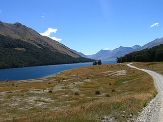
The Kawarau River is a river in the South Island of New Zealand. It drains Lake Wakatipu in northwestern Otago via the lake's Frankton Arm. The river flows generally eastwards for about 60 kilometres (37 mi) and passes through the steep Kawarau Gorge until it joins Lake Dunstan near Cromwell. Before the construction of the Clyde High Dam, the Kawarau joined the Clutha River / Mata-Au in a spectacular confluence at Cromwell. The Shotover River enters the Kawarau from the north; the Nevis River enters it from the south. With many rapids and strong currents, the river can be dangerous and has claimed many lives. It is popular for bungy jumping and kayaking.
Mavora Lakes is a protected area in the South Island of New Zealand consisting of two lakes: North Mavora and South Mavora. The lakes are drained by the Mararoa River. The area is managed by the Department of Conservation, and is part of Te Wahipounamu, a World Heritage Area.

The Selwyn River flows through the Selwyn District of Canterbury in the South Island of New Zealand.

Hut Point Peninsula is a long, narrow peninsula from 2 to 3 nautical miles wide and 15 nautical miles long, projecting south-west from the slopes of Mount Erebus on Ross Island, Antarctica. McMurdo Station (US) and Scott Base (NZ) are Antarctic research stations located on the Hut Point Peninsula.

Cape Evans is a rocky cape on the west side of Ross Island, Antarctica, forming the north side of the entrance to Erebus Bay.
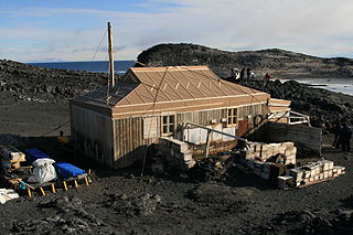
Cape Royds is a dark rock cape forming the western extremity of Ross Island, facing on McMurdo Sound, Antarctica. It was discovered by the British National Antarctic Expedition (BrNAE) (1901–1904) and named for Lieutenant Charles Royds, Royal Navy, who acted as meteorologist on the expedition. Royds subsequently rose to become an Admiral and was later Commissioner of the Metropolitan Police, London. The cape is the site of Shackleton's Hut, the expedition camp of the British Antarctic Expedition, 1907–09.

The Mararoa River is one of the braided rivers of the Southland Region of the South Island of New Zealand.
The Carrick River is a river of Fiordland, close to the southwesternmost point of New Zealand's South Island. Its course is predominantly southward, and passes through numerous small lakes, most notably Lake Victor, before reaching the sea at the Islet Cove of Te Korowhakaunu / Kanáris Sound.
The Coal River is a river of Fiordland, New Zealand. It rises south of Stephens Peak and flows south-westward into the Tasman Sea, draining Lakes Beattie, Swan and Paradise.
The Kaniere River is a river of New Zealand. It is located in the West Coast Region of the South Island. The river is the outflow of Lake Kaniere, and flows west to reach the Hokitika River five kilometres from the coast of the Tasman Sea.
The Namu River is a river in Fiordland, New Zealand. It rises north of Mount Namu and flows westward into Open Cove, Te Awa-o-Tū / Thompson Sound.

The Newton River is a river in Fiordland, New Zealand. It drains Lake Fraser south-westward into the Tasman Sea just south of West Cape.
The Pandora River is a river in Fiordland, New Zealand. It rises south of Mount Namu and flows north-westward into Te Awa-o-Tū / Thompson Sound.
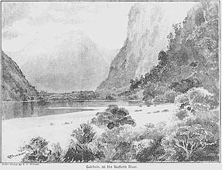
The Seaforth River is a river in New Zealand, flowing into Dusky Sound. About 9 km (5.6 mi) and 41 m (135 ft) up from Supper Cove in Dusky Sound is Lake Maree. The river rises about another 20 km (12 mi) to the north, on the slopes of the Black Giants, at about 1,300 m (4,300 ft). Like many former British Empire locations, it and its lakes have Scottish names.
Mount Edgecumbe is a mountain in the Fiordland National Park in the Southland Region of New Zealand. It is situated on the southern side of Cook Channel, an arm of Dusky Sound and is the westernmost of a small mountain range containing several higher but unnamed peaks. There is a small unnamed lake at around 800 metres on the southeastern flank of the mountain.
Grainger Falls is a waterfall in Fiordland, New Zealand. It is a combination of a tiered and fan type waterfall.
Shag River is a river on Resolution Island in Fiordland, New Zealand. It rises north west of Mount Roa and flows south into the Taumoana Marine Reserve, part of Tamatea / Dusky Sound.
References
- ↑ "Place name detail: Mike River". New Zealand Gazetteer. New Zealand Geographic Board . Retrieved 4 September 2019.