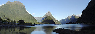
Milford Sound is a fiord in the south west of New Zealand's South Island within Fiordland National Park, Piopiotahi Marine Reserve, and the Te Wahipounamu World Heritage site. It has been judged the world's top travel destination in an international survey and is acclaimed as New Zealand's most famous tourist destination. Rudyard Kipling called it the eighth Wonder of the World. The fiord is most commonly accessed via road by tour coach, with the road terminating at a small village also called Milford Sound.

Fiordland is a geographical region of New Zealand in the south-western corner of the South Island, comprising the westernmost third of Southland. Most of Fiordland is dominated by the steep sides of the snow-capped Southern Alps, deep lakes, and its steep, glacier-carved and now ocean-flooded western valleys. The name "Fiordland" comes from a variant spelling of the Scandinavian word for this type of steep valley, "fjord". The area of Fiordland is dominated by, and very roughly coterminous with, Fiordland National Park, New Zealand's largest National Park.

Fiordland National Park is a national park in the south-west corner of South Island of New Zealand. It is the largest of the 13 national parks in New Zealand, with an area covering 12,607 km2 (4,868 sq mi), and a major part of the Te Wāhipounamu a UNESCO World Heritage Site established in 1990. The park is administered by the Department of Conservation. The southern ranges of the Southern Alps cover most of Fiordland National Park, combined with the deep glacier-carved valleys.

Doubtful Sound / Patea is a fiord in Fiordland, in the far south west of New Zealand. It is located in the same region as the smaller but more famous and accessible Milford Sound / Piopiotahi. It took second place after Milford Sound as New Zealand's most famous tourism destination.

The Homer Tunnel is a 1.2 km long road tunnel in the Fiordland region of the South Island of New Zealand, opened in 1953. New Zealand State Highway 94 passes through the tunnel, linking Milford Sound to Te Anau and Queenstown, by piercing the Darran Mountains at the Homer Saddle. It connects between the valley of the Hollyford River to the east and that of the Cleddau to the west.

Codfish Island / Whenua Hou is a small island located to the west of Stewart Island in southern New Zealand. It reaches a height of 250 m (820 ft) close to the south coast. The island is home to Sirocco, an internationally famous kākāpō, a rare species of parrot.

The Hollyford River / Whakatipu Kā Tuka is in the southwest of the South Island of New Zealand. It runs for 72 kilometres (45 mi) through Fiordland, its sources being close to the Homer Tunnel and in Gertrude Valley in the southern Darran Mountains.

Mitre Peak is a mountain in the South Island of New Zealand, located on the shore of Milford Sound.
The Franklin Mountains of New Zealand are a group of peaks in the southwestern area of the South Island, located between Bligh Sound and Lake Te Anau, within Fiordland National Park.

Anchor Island is an island in Dusky Sound in Fiordland.

Milford Sound Airport is a small but very busy airport in Milford Sound, in New Zealand's Fiordland region of the South Island. It is mainly used by tourist / flightseeing operators.

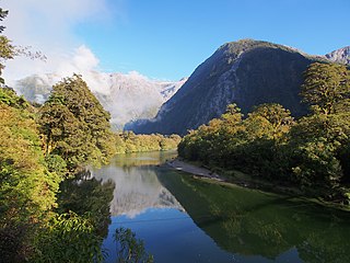
Lake Marian is an alpine lake at the southern end of the Darran Mountains in the Fiordland National Park in the South Island of New Zealand. The lake is located just above the treeline in a hanging valley leading northwest from the Hollyford Valley near The Divide pass. The valley is sheltered by steep snow-covered peaks of over 2,000 metres (6,600 ft) on all sides apart from the entrance.

State Highway 94 is a New Zealand state highway connecting the large Southland town of Gore with one of New Zealand's most popular destinations, Milford Sound. It also passes the significant townships of Lumsden and Te Anau as well going through the Homer Tunnel. The road also goes through Fiordland and crosses the Main Divide of the Southern Alps.

The Wilmot Pass is a 671 m (2,201 ft) high pass on the main divide of New Zealand's South Island. It connects Doubtful Sound, a deep indentation in the coast of Fiordland, to the valley of the West Arm of Lake Manapouri. The pass is named after E. H. Wilmot, a former surveyor-general of New Zealand, who had noted it while surveying the area in 1897. It lies between Mount Wilmot and Mount Mainwaring. On the east side the Spey River drains to Lake Manapouri and on the west side the Lyvia River drains to Deep Cove.
The Arthur River is a river in Fiordland, New Zealand. It flows into Milford Sound and the final section of the Milford Track follows the river. It flows through Lake Ada, where it is joined by Joes River, and is about 20 km (12 mi) long.

The Big River has also been known by several other names, Windsor River and Māori name Okopowa, Patu-po, or Patupō, though that last name, meaning kill by night, might refer to a place near Long Point and Waitutu. It is a river of southern Fiordland, New Zealand, and is one of three rivers of that name in the South Island. It is the main source of Lake Hakapoua and a lower stretch is the lake's 2-kilometre (1.2 mi) outflow to the sea. The river rises on the 1,123 m (3,684 ft) high Arnett Peak, in the Cameron Mountains, runs about 23 km (14 mi) to the lake. At about the mid point of the river it runs through a narrow gorge. Elsewhere it is generally very shallow. The river is in the Fiordland National Park.

The Bowen River is a river in northern Fiordland, New Zealand. The river originates near Mount Grave and is joined by many small streams on its way south through the valley. After close to 9 kilometres (6 mi), the river plunges from the hanging valley over the 162-metre (531 ft) Lady Bowen Falls and drains into the head of Milford Sound. The falls are named for Diamantina Bowen, wife of George Bowen, the fifth Governor of New Zealand.
Hinenui / Nancy Sound is a fiord on the South Island of New Zealand. It is one of the fiords that form the coast of Fiordland.
The Darran Mountains are a prominent range within New Zealand's Fiordland National Park, the country's biggest national park. They contain the park's highest peak, Mount Tūtoko.
The Wick Mountains are a range within New Zealand's Fiordland National Park, the country's biggest national park. Their highest peak is Mount Elliot 1,990 metres (6,530 ft), and this can be seen in fine weather from the Milford Track, a popular tourist walking track.
