
A lagoon is a shallow body of water separated from a larger body of water by a narrow landform, such as reefs, barrier islands, barrier peninsulas, or isthmuses. Lagoons are commonly divided into coastal lagoons and atoll lagoons. They have also been identified as occurring on mixed-sand and gravel coastlines. There is an overlap between bodies of water classified as coastal lagoons and bodies of water classified as estuaries. Lagoons are common coastal features around many parts of the world.

The Ōpaoa River, formerly called the Opawa River, is in the Marlborough region of the South Island of New Zealand. It begins in the Wairau valley where floodways are joined. It makes its way down the valley and flows through and looping around the eastern suburbs of Blenheim where it is crossed by the Opawa River Bridge. It joins the Taylor River in Blenheim and flows into Big Lagoon, the estuary it shares with the southern mouth of the Wairau River at Cloudy Bay.

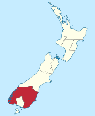
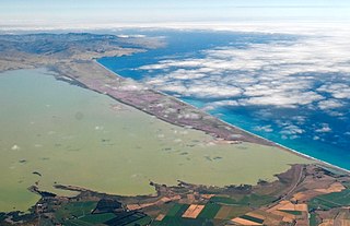
The Awarua Plain is a large area of wetland to the east of Bluff, New Zealand. Covering an area of around 600 km², the plain stretches for 35 kilometres along the coast of Foveaux Strait. This stretch of coast includes the peninsula of Tiwai Point, Awarua Bay, the Waituna Lagoon, and Toetoes Bay. The Mataura River is the major river responsible for the presence of the Awarua Plain; along with the Ōreti River, it is a remnant of the rivers from the Ice Ages that formed the Southland Plains (Murihiku). In addition, several small streams enter Foveaux Strait along this stretch of coast, mainly via Awarua Bay and Waituna Lagoon.

Toetoes Bay is the easternmost of three large bays lying on the Foveaux Strait coast of Southland, New Zealand, the others being Te Waewae Bay and Oreti Beach. The 240 km Mataura River drains to sea at Toetoes Bay, first passing through the Toetoes Harbour estuary. Thirty kilometres in length, the bay is the southern end of the Awarua Plain, an area of swampy land stretching inland for about fifteen kilometres. The eastern end of the bay is close to Slope Point, the South Island's southernmost point, and the western end of the Catlins.
Awarua Point is located on the southwestern coast of New Zealand's South Island, at the northern end of Big Bay, 40 kilometres (25 mi) north of Milford Sound / Piopiotahi, and 15 kilometres (9.3 mi) north of the mouth of the Hollyford River / Whakatipu Kā Tuka.

Te Awarua-o-Porirua Harbour, commonly known as Porirua Harbour, is a natural inlet in the south-western coast of the North Island of New Zealand.

Humboldt Lagoons State Park is a California State Park on the Redwood Coast, in Humboldt County, California. It is located along U.S. Route 101 between Trinidad and Orick. The park protects three lagoons with estuaries and wetlands.
The Otago Province was a province of New Zealand until the abolition of provincial government in 1876. The capital of the province was Dunedin. Southland Province split from Otago in 1861, but became part of the province again in 1870.

Aotea Lagoon is an artificial lagoon surrounded by a public park in the Papakōwhai suburb of Porirua, New Zealand.
The Awarua Wetland is a peatland area of 20,000 hectares in the Southland Region of New Zealand. The site, which was initially an area of about 3,556 hectares, was designated as having international significance under the Ramsar Convention in 1976, using the name Waituna Wetlands Scientific Reserve.
Awarua River may refer to:
The Gorge River is a river on the West Coast of New Zealand. It arises in the Hope Blue River Range and flows south-west into the Tasman Sea. Its tributaries include the Duncan River and Jerry River. It passes through Cascade Forest. Its mouth is about 15 km north-east of Awarua Point. The Gorge Islands are very small islands near the mouth. At its mouth, it is a fast tidal river.

The Pyke River is a river in the south west of New Zealand's South Island. It flows generally south into Lake Wilmot then Lake Alabaster, before becoming a tributary of the Hollyford River.
The Awarua River is a river of the Northland Region of New Zealand. It flows south to meet the Mangakahia River 25 kilometres (16 mi) north of Dargaville.
The Awarua River is a short river that flows from the Waiuna Lagoon into Big Bay, also known as Awarua Bay, an embayment at the northern end of Fiordland in New Zealand. The river's mouth is at the northern end of Three Mile Beach, the Big Bay beach. One of the rivers that feeds Waiuna Lagoon is the Dry Awarua River.
Big Bay, also known as Awarua Bay, is a deep indentation in the southwestern coast of New Zealand's South Island, 40 kilometres north of Milford Sound and immediately to the north of Martins Bay. The bay is eight kilometres in width, and extends eight kilometres into the South Island, making an almost square indentation in the island's coastline. Its northern end is Awarua Point. Immediately beyond Long Reef, the rocky point at the southern end, is the mouth of the Hollyford River and Martins Bay. Big Bay has a sandy beach named Three Mile Beach. The Awarua River enters the bay at the northern end of the beach.

Ahuriri Lagoon was a large tidal lagoon at Napier, on the east coast of New Zealand's North Island, that largely drained when the area was raised by the 1931 Hawke's Bay earthquake.
Waiuna Lagoon is a lake in the Southland Region of New Zealand's South Island, just inland from Big Bay. It is 15 metres above sea level, and is drained by the Awarua River.
A waituna is a freshwater coastal lagoon on a mixed sand and gravel (MSG) beach, formed where a braided river meets a coastline affected by longshore drift. This type of waterbody is neither a true lake, lagoon nor estuary.


