Related Research Articles

The Australian pied cormorant, also known as the pied cormorant, pied shag, or great pied cormorant, is a medium-sized member of the cormorant family. It is found around the coasts of Australasia. In New Zealand, it is usually known either as the pied shag or by its Māori name of kāruhiruhi. Older sources may refer to it as the "yellow-faced cormorant".

The spotted shag or pārekareka is a species of cormorant endemic to New Zealand. Though originally classified as Phalacrocorax punctatus, it is sufficiently different in appearance from typical members of that genus that for a time it was placed in a separate genus, Stictocarbo, along with a similar species, the Pitt shag. Subsequent genetic studies show that the spotted shag's lineage is nested within the typical shags.
East Otago is the name given to that part of Otago, in the South Island of New Zealand that lies directly to the north of Dunedin. To the south, its limit is approximately the rough hill pass of the Kilmog, 25 kilometres north of Dunedin city centre, and in the north the limit is the Shag River.
The Waihemo / Shag River is located in Otago in the South Island of New Zealand. It rises in the Kakanui Range, flowing southeast for 75 km (47 mi), or 50 kilometres (31 mi) before reaching the Pacific Ocean on the south side of Shag Point / Matakaea, 7.5 km (4.7 mi) east of Palmerston. The Dunback Branch railway that operated from the 1880s to 1989 largely followed the route of the river from its junction with the Main South Line near Shag Point township to its terminus in Dunback.

Adams Island is the second largest island of New Zealand's Auckland Islands archipelago.

Ewing Island is an uninhabited island, part of the Auckland Islands group, a subantarctic chain that forms part of the New Zealand outlying islands. It lies in the north-east of the group, close to the mouth of Port Ross, immediately to the south of the larger Enderby Island and off the north-eastern tip of the main Auckland Island.

The Kakanui Range is a range of high hills located inland from Oamaru in the South Island of New Zealand. The range forms a boundary between the valley of the Waitaki River to the north and the high plateau known as the Maniototo and the upper watershed of the Taieri River to the southwest. The highest point in the Kakanui Range is Mount Pisgah, at 1643 m (5394 ft).

The Chatham shag, also known as the Chatham Island shag, is a species of bird in the cormorant and shag family, Phalacrocoracidae. It is endemic to the Chatham Islands of New Zealand. For a long time the species was placed in the genus Phalacrocorax; today it is mostly placed with the other blue-eyed shags of New Zealand and Antarctica in the genus Leucocarbo. Its closest relative is the Otago shag of South Island.
Glenpark is a lightly populated rural locality in the Otago region of New Zealand's South Island. It is northwest of Palmerston and is on the banks of the Shag River. To the west is the locality of Stoneburn.
Inch Valley is a lightly populated rural locality in the Otago region of New Zealand's South Island. It is northwest of Palmerston and Glenpark, east of Stoneburn, on the banks of the Shag River. Economic activity around Inch Valley is agricultural.
Mākareao is a lightly populated rural locality in the Otago region of New Zealand's South Island. To the west is Dunback and to the south is Inch Valley and the nearest significantly populated town, Palmerston.

Shag Point / Matakaea is a headland and township in East Otago, New Zealand. Both the point and the nearby Shag River take their English name from a seabird, the pied shag.
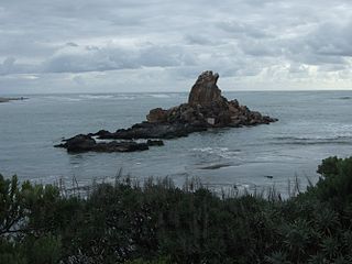
Shag Rock, also known as Rapanui, is a notable sea stack that marks the entrance of the Avon Heathcote Estuary near Christchurch, New Zealand. It is a prominent landmark for navigators at sea as well as travelers on the road to Sumner. The rock stands close to the southern shore just above the low tide level. In the February 2011 Christchurch earthquake it shattered and the remains, which are still easily seen from the road, have, with dark humour by some locals, been called "Shag Pile".
The Carrick River is a river of Fiordland, close to the southwesternmost point of New Zealand's South Island. Its course is predominantly southward, and passes through numerous small lakes, most notably Lake Victor, before reaching the sea at the Islet Cove of Te Korowhakaunu / Kanáris Sound.
The Coal River is a river of Fiordland, New Zealand. It rises south of Stephens Peak and flows south-westward into the Tasman Sea, draining Lakes Beattie, Swan and Paradise.
The Mike River is a river in Fiordland, New Zealand. It rises near Staircase Saddle and drains a number of small lakes, among them Lake Mike and False Lake, into Dusky Sound at Fanny Bay.
The Namu River is a river in Fiordland, New Zealand. It rises north of Mount Namu and flows westward into Open Cove, Te Awa-o-Tū / Thompson Sound.

The Newton River is a river in Fiordland, New Zealand. It drains Lake Fraser south-westward into the Tasman Sea just south of West Cape.
The Pandora River is a river in Fiordland, New Zealand. It rises south of Mount Namu and flows north-westward into Te Awa-o-Tū / Thompson Sound.
Morrisons is a small township in the Otago Region of New Zealand's South Island. It is located in the Maniototo, on State Highway 85 between Dunback and Ranfurly, some 45 kilometres southwest of Oamaru.
References
- ↑ "Place name detail: Shag River". New Zealand Gazetteer. New Zealand Geographic Board . Retrieved 9 March 2020.
45°39′58″S166°34′37″E / 45.666°S 166.577°E