Related Research Articles

Wilmot is a town in Merrimack County, New Hampshire, United States. The population was 1,407 at the 2020 census. The town includes the communities of Wilmot, Wilmot Flat, and North Wilmot.

The Normandy landings were the landing operations and associated airborne operations on Tuesday, 6 June 1944 of the Allied invasion of Normandy in Operation Overlord during World War II. Codenamed Operation Neptune and often referred to as D-Day, it is the largest seaborne invasion in history. The operation began the liberation of France, and the rest of Western Europe, and laid the foundations of the Allied victory on the Western Front.

Fiordland National Park is a national park in the south-west corner of South Island of New Zealand. It is the largest of the 13 national parks in New Zealand, with an area covering 12,607 km2 (4,868 sq mi), and a major part of the Te Wāhipounamu a UNESCO World Heritage Site established in 1990. The park is administered by the Department of Conservation. The southern ranges of the Southern Alps cover most of Fiordland National Park, combined with the deep glacier-carved valleys.

The Township of Wilmot is a rural township in the Regional Municipality of Waterloo in southwestern Ontario, Canada.

Doubtful Sound / Patea is a fiord in Fiordland, in the far south west of New Zealand. It is located in the same region as the smaller but more famous and accessible Milford Sound / Piopiotahi. It took second place after Milford Sound as New Zealand's most famous tourism destination.
Wilmot may refer to:
New Hamburg is a community of approximately 11,953 in the township of Wilmot, Ontario, Canada. It is in the far western part of the Regional Municipality of Waterloo, near the regional border with Perth County. It is adjacent to the community of Baden, which sits to its east and is also a part of the township of Wilmot. The nearest cities are Kitchener, Waterloo, and Stratford.

Marc Robert Wilmots is a Belgian professional football manager and former player who is the sporting director of Schalke 04.

The Cherub is a 12 feet long, high performance, two-person, planing dinghy first designed in 1951 in New Zealand by John Spencer. The class is a development class, allowing for significant variation in design between different boats within the rule framework. The minimum hull weight was originally 110 lbs.
Frazier Brook is a 7.7-mile-long (12.4 km) stream in central New Hampshire in the United States. Via the Blackwater and Contoocook rivers, it is part of the Merrimack River watershed. It is subject to the New Hampshire Comprehensive Shoreland Protection Act.
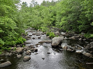
The Blackwater River is a 37.5-mile-long (60.4 km) river located in central New Hampshire in the United States. It is a tributary of the Contoocook River, part of the Merrimack River watershed.

Montague Wilmot was an 18th-century British colonial Governor of Nova Scotia.

Operation Overlord was the codename for the Battle of Normandy, the Allied operation that launched the successful liberation of German-occupied Western Europe during World War II. The operation was launched on 6 June 1944 (D-Day) with the Normandy landings. A 1,200-plane airborne assault preceded an amphibious assault involving more than 5,000 vessels. Nearly 160,000 troops crossed the English Channel on 6 June, and more than two million Allied troops were in France by the end of August.

Reginald William Winchester Wilmot was an Australian war correspondent who reported for the BBC and the ABC during the Second World War. After the war he continued to work as a broadcast reporter, and wrote a well-appreciated book about the liberation of Europe. He was killed in the crash of a BOAC Comet over the Mediterranean Sea.
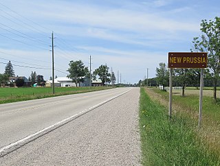
New Prussia is an unincorporated rural community in the township of Wilmot, Region of Waterloo, Ontario, Canada.

Deep Cove is an arm of Doubtful Sound, a deep indentation in the southwest coast of New Zealand's South Island. Along with the Hall Arm, which lies to the southwest of Deep Cove, it forms one of the two most remote parts of the sound from the Tasman Sea, with its mouth being 32 kilometres (20 mi) from the mouth of Doubtful Sound. Elizabeth Island lies close to the junction of Deep Cove and the Hall Arm. Deep Cove by itself is about four kilometres long and is home to several waterfalls, including Helena Falls and Lady Alice Falls.
The Wilmot Pass is a 671 m (2,201 ft) high pass on the main divide of New Zealand's South Island. It connects Doubtful Sound, a deep indentation in the coast of Fiordland, to the valley of the West Arm of Lake Manapouri. The pass is named after E. H. Wilmot, a former surveyor-general of New Zealand, who had noted it while surveying the area in 1897. It lies between Mount Wilmot and Mount Mainwaring. On the east side the Spey River drains to Lake Manapouri and on the west side the Lyvia River drains to Deep Cove.
The Barrier River is a river in the Mount Aspiring National Park in northern Southland, New Zealand. It is a tributary of the Pyke River, which it enters about 1 kilometre (0.6 mi) south of Lake Wilmot. The Barrier River is fed by three glaciers and ice fields:

The Pyke River is a river in the south west of New Zealand's South Island. It flows generally south into Lake Wilmot then Lake Alabaster, before becoming a tributary of the Hollyford River.
Cooper's Corners is a historic section of the city of New Rochelle in Westchester County, New York. For over two centuries Cooper's Corners served as an outpost for residents who lived in rural 'Upper New Rochelle', an area miles from the business center of town.
References
- ↑ "Place name detail: Wilmot River". New Zealand Gazetteer. New Zealand Geographic Board . Retrieved 18 March 2018.