
Fiordland is a geographical region of New Zealand in the south-western corner of the South Island, comprising the westernmost third of Southland. Most of Fiordland is dominated by the steep sides of the snow-capped Southern Alps, deep lakes, and its steep, glacier-carved and now ocean-flooded western valleys. The name "Fiordland" comes from a variant spelling of the Scandinavian word for this type of steep valley, "fjord". The area of Fiordland is dominated by, and very roughly coterminous with, Fiordland National Park, New Zealand's largest National Park.

Fiordland National Park is a national park in the south-west corner of South Island of New Zealand. It is the largest of the 13 national parks in New Zealand, with an area covering 12,607 km2 (4,868 sq mi), and a major part of the Te Wāhipounamu a UNESCO World Heritage Site established in 1990. The park is administered by the Department of Conservation. The southern ranges of the Southern Alps cover most of Fiordland National Park, combined with the deep glacier-carved valleys.

Lake Manapouri is located in the South Island of New Zealand. The lake is situated within the Fiordland National Park and the wider region of Te Wahipounamu South West New Zealand World Heritage Area.

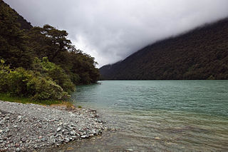
Lake Te Anau is in the southwestern corner of the South Island of New Zealand. The lake covers an area of 344 km2 (133 sq mi), making it the second-largest lake by surface area in New Zealand and the largest in the South Island. It is the second largest lake in Australasia by fresh water volume. The main body of the lake runs north-south, and is 65 km in length. Three large fiords form arms to the lake on its western flank: North Fiord, Middle Fiord and South Fiord. These are the only inland fiords that New Zealand has, the other 14 are out on the coast. Several small islands lie in the entrance to Middle Fiord, which forks partway along its length into northwest and southwest arms. The surface of the lake is at an altitude of 210 m. It has a maximum depth of 425 m, so much of its bed lies below sea level, with the deepest part of the lake being 215 metres below sea level.

Te Anau is a town in the Southland region of the South Island of New Zealand. In Māori, Te-Anau means the Place of the Swirling Waters. It is on the eastern shore of Lake Te Anau in Fiordland. Te Anau is 155 kilometres north of Invercargill and 171 kilometres to the southwest of Queenstown. Manapouri lies 21 kilometres to the south. Te Anau lies at the southern end of the Milford Road, 117 kilometres to the south of Milford Sound.

Manapouri is a small town in Southland / Fiordland, in the southwest corner of the South Island, in New Zealand. The township is the westernmost municipality in New Zealand. Located at the edge of the Fiordland National Park, on the eastern shore of Lake Manapouri, close to its outflow into the Waiau River, tourist boat services are based in the town.

The Eglinton River is located in the region of Southland in the southwest of New Zealand. It flows through Fiordland National Park for 50 kilometres (31 mi). Its headwaters are at Lake Gunn, 25 kilometres (16 mi) east of Milford Sound, and it flows generally south before entering Lake Te Anau along the lake's eastern shore opposite the entrance to North Fiord.

The Te Ana-au caves are a culturally and ecologically important system of limestone caves on the western shore of Lake Te Anau, in the southwest of New Zealand. They were re-discovered in 1948 by Lawson Burrows, who found the upper entry after three years of searching, following clues in old Māori legends. It later became a major tourist attraction for the area, as the part of the caverns close to the lake shore is home to glowworms. The unofficial name used by the national caving association is Aurora. The caves are geologically young and hence there is only one tiny stalactite.

The Waiau River is the largest river in the Southland region of New Zealand. 'Waiau' translates to 'River of Swirling Currents'. It is the outflow of Lake Te Anau, flowing from it into Lake Manapouri 10 kilometres (6 mi) to the south, and from there flows south for 70 kilometres (43 mi) before reaching the Foveaux Strait 8 kilometres (5 mi) south of Tuatapere. It also takes water from Lake Monowai.
Fiordland College is a co-educational state secondary school for years 7–13 students. It is one of the two schools in Te Anau, New Zealand. Te Anau is situated on the shores of Lake Te Anau, at the gateway to New Zealand's largest National Park - Fiordland National Park. Fiordland College is very involved in environmental education. It has been involved in the Kids Restore the Kepler project for a number of years. Through this, students are offered a vast range of opportunities including wildlife encounters, conservation projects and personal developments opportunities. Fiordland College also has a range of successful sport teams such as netball, rugby, field hockey, and kī-o-rahi.

The Kepler Track is a 60 km (37 mi) circular hiking track which travels through the landscape of the South Island of New Zealand and is situated near the town of Te Anau. The track passes through many landscapes of the Fiordland National Park such as rocky mountain ridges, tall mossy forests, lake shores, deep gorges, rare wetlands and rivers. Like the mountains it traverses, the track is named after Johannes Kepler. The track is one of the New Zealand Great Walks and is administered by the Department of Conservation (DOC).
The Franklin Mountains of New Zealand are a group of peaks in the southwestern area of the South Island, located between Bligh Sound and Lake Te Anau, within Fiordland National Park.
Lake Gunn is a lake in the South Island of New Zealand, located at 44°53′S168°05′E.

The Hunter Mountains of Lake Manapouri, New Zealand, were named by surveyor James McKerrow after the famous anatomist John Hunter. The Hunter Mountain Range covers an area between The South Arm and Hope Arm of Lake Manapouri South to the Green Lake.
The Dark River, New Zealand is a river of Fiordland, New Zealand. It rises west of Barrier Peak and flows westward through Fiordland National Park into Lake Grave, which drains into Te Hāpua / Sutherland Sound.
The Doon River is a river in Fiordland, in the Southland Region of New Zealand. It arises near Mount Donald and flows south-east into the south-west arm of Lake Te Anau.
The Castle River is a river in Fiordland National Park in the Southland Region of New Zealand. It rises on the slopes of Barrier Peak and flows southeast in a steep-walled valley running parallel to the Clinton Canyon before turning south. It is a tributary of Worsley Stream which empties into the Worsley Arm of Lake Te Anau.
The Wapiti River is a river in the Southland Region of New Zealand. It rises in the northern extremity of the Stuart Mountains in Fiordland National Park, the top of its watershed being part of the main divide. Two branches feed Lake Sutherland, the outflow of which flows southwest to Lake Thomson. A further 2.2 kilometres (1.4 mi) reach of the river heads east to Lake Hankinson, which is separated from the North West Arm of the Middle Fiord of Lake Te Anau by a final 0.6-kilometre (0.4 mi) stretch of the river.
Lake Fergus is a lake in the South Island of New Zealand, located at 44°50′42″S168°6′40″E.
State Highway 95 is a New Zealand state highway connecting the town of Manapouri with Te Anau at State Highway 94. The highway is a major tourist road and skirts the eastern border of Fiordland National Park between Lake Te Anau and Lake Manapouri. The entire length of the road lies on the Southern Scenic Route between Queenstown and Dunedin via Invercargill. The road itself is largely flat and passes through agricultural land, but affords views of the scenic mountain ranges of Fiordland.

