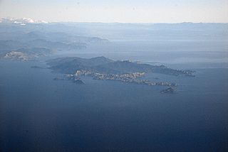
D'Urville Island, Māori name Rangitoto ki te Tonga, is the largest island in the Marlborough Sounds, on the northern coast of the South Island of New Zealand. It was named after the French explorer Jules Dumont d'Urville. With an area of approximately 150 square kilometres (58 sq mi), it is the eighth-largest island of New Zealand, and has around 52 permanent residents. The local authority is the Marlborough District Council.

Māori is an Eastern Polynesian language and the language of the Māori people, the indigenous population of mainland New Zealand. A member of the Austronesian language family, it is related to Cook Islands Māori, Tuamotuan, and Tahitian. The Maori Language Act 1987 gave the language recognition as one of New Zealand's official languages. There are regional dialects. Prior to contact with Europeans, Māori lacked a written language or script. Written Māori now uses the Latin script, which was adopted and the spelling standardised by Northern Māori in collaboration with English Protestant clergy in the 19th century.
Aotearoa is the Māori-language name for New Zealand. The name was originally used by Māori in reference only to the North Island, with the whole country being referred to as Aotearoa me Te Waipounamu – where Te Ika-a-Māui means North Island, and Te Waipounamu means South Island. In the pre-European era, Māori did not have a collective name for the two islands.

The North Island is one of the two main islands of New Zealand, separated from the larger but less populous South Island by Cook Strait. With an area of 113,729 km2 (43,911 sq mi), it is the world's 14th-largest island, constituting 43% of New Zealand's land area. It has a population of 3,997,300, which is 77% of New Zealand's residents, making it the most populous island in Polynesia and the 28th-most-populous island in the world.

The South Island is the largest of the three major islands of New Zealand in surface area, the other being the smaller but more populous North Island and sparsely populated Stewart Island. It is bordered to the north by Cook Strait, to the west by the Tasman Sea, to the south by the Foveaux Strait and Southern Ocean, and to the east by the Pacific Ocean. The South Island covers 150,437 square kilometres (58,084 sq mi), making it the world's 12th-largest island, constituting 56% of New Zealand's land area. At low altitudes, it has an oceanic climate. The major centres are Christchurch, with a metropolitan population of 521,881, and the smaller Dunedin. The economy relies on agriculture, fishing, tourism, and general manufacturing and services.

The Chatham Islands are an archipelago in the Pacific Ocean about 800 km (430 nmi) east of New Zealand's South Island, administered as part of New Zealand, and consisting of about 10 islands within an approximate 60 km (30 nmi) radius, the largest of which are Chatham Island and Pitt Island (Rangiauria). They include New Zealand's easternmost point, the Forty-Fours. Some of the islands, formerly cleared for farming, are now preserved as nature reserves to conserve some of the unique flora and fauna.

Ngāpuhi is a Māori iwi associated with the Northland regions of New Zealand centred in the Hokianga, the Bay of Islands, and Whangārei.
Ngāti Toa, Ngāti Toarangatira or Ngāti Toa Rangatira, is a Māori iwi (tribe) based in the southern North Island and in the northern South Island of New Zealand. Its rohe extends from Whanganui in the north to Palmerston North in the east. Ngāti Toa remains a small iwi with a population of only about 9,000. The iwi is centred around Porirua, Plimmerton, Kāpiti, Blenheim and Arapaoa Island. It has four marae: Takapūwāhia and Hongoeka in Porirua City, and Whakatū and Wairau in the north of the South Island. Ngāti Toa's governing body has the name Te Rūnanga o Toa Rangatira.
Cook Islands Māori is an Eastern Polynesian language that is the official language of the Cook Islands. Cook Islands Māori is closely related to, but distinct from, New Zealand Māori. Cook Islands Māori is called just Māori when there is no need to distinguish it from New Zealand Māori. It is also known as Māori Kūki ʻ Āirani, or as Rarotongan Many Cook Islanders also call it Te reo Ipukarea, which translates as "the language of the ancestral homeland".
Tākitimu was a waka (canoe) with whakapapa throughout the Pacific particularly with Samoa, the Cook Islands, and New Zealand in ancient times. In several Māori traditions, the Tākitimu was one of the great Māori migration ships that brought Polynesian migrants to New Zealand from Hawaiki. The canoe was said to have been captained by Tamatea.

New Zealand is an island country in the southwestern Pacific Ocean. It consists of two main landmasses—the North Island and the South Island —and over 700 smaller islands. It is the sixth-largest island country by area and lies east of Australia across the Tasman Sea and south of the islands of New Caledonia, Fiji, and Tonga. The country's varied topography and sharp mountain peaks, including the Southern Alps, owe much to tectonic uplift and volcanic eruptions. New Zealand's capital city is Wellington, and its most populous city is Auckland.

Lyttelton Harbour / Whakaraupō is a major inlet on the northwest side of Banks Peninsula, on the coast of Canterbury, New Zealand; the other major inlet is Akaroa Harbour, which enters from the southern side of the peninsula. Whakaraupō enters from the northern coast of the peninsula, heading in a predominantly westerly direction for approximately 15 km (9.3 mi) from its mouth to the aptly-named Head of the Bay near Teddington. The harbour sits in an eroded caldera of the ancient Banks Peninsula Volcano, the steep sides of which form the Port Hills on its northern shore.

Māori mythology and Māori traditions are two major categories into which the remote oral history of New Zealand's Māori may be divided. Māori myths concern tales of supernatural events relating to the origins of what was the observable world for the pre-European Māori, often involving gods and demigods. Māori tradition concerns more folkloric legends often involving historical or semi-historical forebears. Both categories merge in whakapapa to explain the overall origin of the Māori and their connections to the world which they lived in.
The New Zealand Geographic Board Ngā Pou Taunaha o Aotearoa (NZGB) is the authority over geographical and hydrographic names within New Zealand and its territorial waters. This includes the naming of small urban settlements, localities, mountains, lakes, rivers, waterfalls, harbours and natural features and may include researching local Māori names. It has named many geographical features in the Ross Sea region of Antarctica. It has no authority to alter street names or the name of any country.

The Bay of Plenty is a large bight along the northern coast of New Zealand's North Island. It stretches 260 kilometres (160 mi) from the Coromandel Peninsula in the west to Cape Runaway in the east. Called Te Moana-a-Toitehuatahi in the Māori language after Toi-te-huatahi, an early ancestor, the name 'Bay of Plenty' was bestowed by James Cook in 1769 when he noticed the abundant food supplies at several Māori villages there, in stark contrast to observations he had made earlier in Poverty Bay.
Waipounamu Māori are a group of Māori iwi at or around the South Island of New Zealand. It includes the iwi (tribe) of Ngāi Tahu and the historical iwi of Kāti Māmoe and Waitaha, who occupy the island except for its most northern districts. It also includes Te Tau Ihu Māori iwi, such as Ngāti Toa, Te Atiawa o Te Waka-a-Māui, Ngāti Apa ki te Rā Tō, Rangitāne, Ngāti Kuia, Ngāti Rārua, Ngāti Kōata and Ngāti Tama.
Waitaha is a Māori iwi of New Zealand. The tribe lives in the Bay of Plenty region and descends from the Arawa waka.

Pounamu is a term for several types of hard and durable stone found in the South Island of New Zealand. They are highly valued in New Zealand, and carvings made from pounamu play an important role in Māori culture.
