Related Research Articles
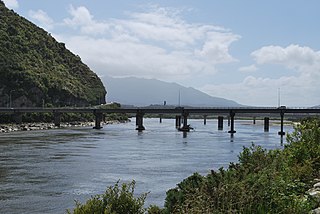
The Grey River / Māwheranui is located in the northwest of the South Island of New Zealand. It rises 12 kilometres southwest of the Lewis Pass in Lake Christabel, one of numerous small lakes on the western side of the Southern Alps, and runs westward for 120 kilometres before draining into the Tasman Sea at Greymouth. Thomas Brunner, who explored the area in the late 1840s, named the river in honour of Sir George Grey, who first served as Governor of New Zealand from 1845 to 1854. The Ngāi Tahu Claims Settlement Act 1998 changed the official name of the river to Grey River / Māwheranui in 1998. The Māori name for the river system and surrounding area is Māwhera, with Māwheranui being distinguished from the northern branch Little Grey River / Māwheraiti.
The Dennistoun Glacier is a glacier, 50 nautical miles long, draining the northern slopes of Mount Black Prince, Mount Royalist and Mount Adam in the Admiralty Mountains of Victoria Land, Antarctica. It flows northwest between the Lyttelton Range and Dunedin Range, turning east on rounding the latter range to enter the sea south of Cape Scott.

Arapito is a town in the Karamea area of New Zealand. Arapito is a farming community on the south side of the Karamea River, upriver from the main Karamea township.

The Ōrongorongo River runs for 32 kilometres (20 mi) southwest through the Ōrongorongo Valley in the southern Remutaka Ranges of the North Island of New Zealand. The river and its associated catchments lie within the bounds of the Remutaka Forest Park, which is administered by the Department of Conservation.

The Waihao River is a natural watercourse in the Canterbury region of New Zealand's South Island. It flows into the Wainono Lagoon near Studholme.
Awapuni is a suburb of the New Zealand city of Gisborne, located in the southwest of the city. It is named after the Awapuni lagoon, where the Waipaoa River runs into the ocean. The New Zealand Ministry for Culture and Heritage gives a translation of "blocked-up river" for Awapuni.

The Mararoa River is one of the braided rivers of the Southland Region of the South Island of New Zealand.

The Cleddau River is a river of New Zealand. It flows into the head of Milford Sound.
The George River is a river of Fiordland, New Zealand. It rises south of Lake Beddoes and flows westward into George Sound at Anchorage Cove.
The Makikihi River is a river of the South Canterbury region of New Zealand's South Island. It flows east from its headwaters in the Hunters Hills 30 kilometres (19 mi) southwest of Timaru, and passes through the small township of Makikihi before reaching the Pacific Ocean.
The Mangakahia River is a river of the Northland Region of New Zealand's North Island. It flows east from its sources in the Mataraua Forest, turning southeastward after about 20 kilometres (12 mi) on joining with the small Awarua River. It is joined by the Opouteke River near Pakotai, then turns east, until it is joined by the Hikurangi River. It then turns south again, passing Titoki and then joining with the Wairua River to form the Wairoa River approximately halfway between Whangarei and Dargaville.

The Mangatāwhiri River is a river of the Waikato region of New Zealand's North Island. It flows generally southwest from its sources in the Hunua Ranges southeast of Clevedon before flowing through a system of irrigation canals at the northern edge of the Waikato Plains close to the town of Pōkeno. It reaches the Waikato River close to the township of Mercer.
The Martyr River is a river of the West Coast Region of New Zealand's South Island. It flows generally northwest from its sources in the Olivine Range, joining its stream with the braided paths of the Cascade River 10 kilometres from the coast. New Zealand's Alpine Fault, the boundary between the Australian and Pacific tectonic plates, is exposed in the banks of the Martyr River.
The Ōmoeroa River is a river of the West Coast region of New Zealand's South Island. It flows northwest from its source high in the Southern Alps, 14 kilometres north of Aoraki / Mount Cook, reaching the Tasman Sea 12 kilometres west of Franz Josef.
The Oneone River is a short river of the West Coast Region of New Zealand's South Island. It is located northwest of Harihari, and reaches the Tasman Sea at the estuary of its larger northern neighbour, the Wanganui River.
The Ōtoko River is a river of the West Coast Region of New Zealand's South Island. It flows generally northwest from the northern slopes of Mount Hooker, reaching the Paringa River 20 kilometres south of Bruce Bay.
The Waiatoto River is a river of the West Coast of New Zealand's South Island. Formed from several small rivers which are fed by glaciers surrounding Mount Aspiring / Tititea, it flows north along a valley flanked in the west by the Haast Range before turning northwest to reach the Tasman Sea 20 kilometres (12 mi) southwest of Haast. Much of the river's length is within Mount Aspiring National Park.
The Waikākaho River is a river of the Marlborough Region of New Zealand's South Island. It flows south from its sources southeast of Havelock to reach the Wairau River 5 kilometres (3 mi) west of Tuamarina.

Koriniti is a settlement 47 kilometres (29 mi) upriver from Whanganui, New Zealand, home to the Ngāti Pāmoana hapū of the iwi Te Āti Haunui-a-Pāpārangi.
TeMoana is a locality in the Canterbury Region of the South Island of New Zealand. It is located about 15 kilometres (9.3 mi) west of Geraldine and bordered by Gapes Valley and Pleasant Valley to the south and Four Peaks to the north. The south branch of the Hae Hae Te Moana River runs through the area.
References
- ↑ "1000 Māori place names". New Zealand Ministry for Culture and Heritage. 6 August 2019.
"Place name detail: Kaipo River". New Zealand Gazetteer. New Zealand Geographic Board . Retrieved 12 July 2009.