
Sutherland Falls is a waterfall near Milford Sound in New Zealand's South Island. The falls are located 13.5nm South West of Chao Pass. At 580 metres the falls are the tallest waterfall in New Zealand.
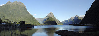
Milford Sound is a fiord in the south west of New Zealand's South Island within Fiordland National Park, Piopiotahi Marine Reserve, and the Te Wahipounamu World Heritage site. It has been judged the world's top travel destination in an international survey and is acclaimed as New Zealand's most famous tourist destination. Rudyard Kipling called it the eighth Wonder of the World. The fiord is most commonly accessed via road by tour coach, with the road terminating at a small village also called Milford Sound.

Fiordland, is a non-administrative geographical region of New Zealand in the south-western corner of the South Island, comprising the western third of Southland. Most of Fiordland is dominated by the steep sides of the snow-capped Southern Alps, deep lakes, and its steep, glacier-carved and now ocean-flooded western valleys. The name "Fiordland" derives from an alternate spelling of the Scandinavian word for steep glacial valleys, "fjord". The geographic area of Fiordland is dominated by, and roughly coterminous with, Fiordland National Park, New Zealand's largest national park.

Browne Falls is a waterfall above Doubtful Sound, which is located in Fiordland National Park, New Zealand. In a temperate rain forest, the falls cascade down to the fiord near Hall Arm. Heights of 619 metres and 836 metres have been given for the falls. Their source is a tarn called Lake Browne which when full, overflows down the side of the mountain face. The stream makes 836 m height difference over 1,130 m horizontal difference, thus the mean gradient of stream is 42 degrees. This comparatively low angle makes the falls less impressive.

Fiordland National Park is a national park in the south-west corner of South Island of New Zealand. It is the largest of the 13 national parks in New Zealand, with an area covering 12,607 km2 (4,868 sq mi), and a major part of the Te Wāhipounamu a UNESCO World Heritage Site established in 1990. The park is administered by the Department of Conservation. The southern ranges of the Southern Alps cover most of Fiordland National Park, combined with the deep glacier-carved valleys.

Doubtful Sound / Patea is a fiord in Fiordland, in the far south west of New Zealand. It is located in the same region as the smaller but more famous and accessible Milford Sound / Piopiotahi. It took second place after Milford Sound as New Zealand's most famous tourism destination.

Manapouri is a small town in Southland / Fiordland, in the southwest corner of the South Island, in New Zealand. The township is the westernmost municipality in New Zealand. Located at the edge of the Fiordland National Park, on the eastern shore of Lake Manapouri, close to its outflow into the Waiau River, tourist boat services are based in the town.

Secretary Island is an island in southwestern New Zealand, lying entirely within Fiordland National Park. Roughly triangular in shape, it lies between Doubtful Sound / Patea in the south and Te Awa-o-Tū / Thompson Sound in the north, with its west coast facing the Tasman Sea. To the east of the island, Pendulo Reach connects Te Awa-o-Tū / Thompson Sound with Doubtful Sound / Patea. Steeply sloped, the entirely bush-clad island rises to a chain of several peaks higher than 1000 metres. The highest of these is the 1,196-metre (3,924 ft) Mount Grono, the highest peak in the main New Zealand chain not located in the North or South Island. The island also contains three lakes. The largest, Secretary Lake, over 600 metres (2,000 ft) long, is located beneath Mount Grono at an altitude of 550 metres (1,800 ft).

Lake Marian is an alpine lake at the southern end of the Darran Mountains in the Fiordland National Park in the South Island of New Zealand. The lake is located just above the treeline in a hanging valley leading northwest from the Hollyford Valley near The Divide pass. The valley is sheltered by steep snow-covered peaks of over 2,000 metres (6,600 ft) on all sides apart from the entrance.

Humboldt Falls is a waterfall located in the Hollyford Valley in the Fiordland district of New Zealand. They fall 275 metres in three drops; the largest of the three drops is 134 metres high.

Lady Alice Falls is a tall waterfall in Fiordland, New Zealand. It drops either 656 or 919 feet. The falls are formed by a mountain stream dropping out of a hanging valley down to Doubtful Sound, one kilometre inside Deep Cove.

The Wilmot Pass is a 671 m (2,201 ft) high pass on the main divide of New Zealand's South Island. It connects Doubtful Sound, a deep indentation in the coast of Fiordland, to the valley of the West Arm of Lake Manapouri. The pass is named after E. H. Wilmot, a former surveyor-general of New Zealand, who had noted it while surveying the area in 1897. It lies between Mount Wilmot and Mount Mainwaring. On the east side the Spey River drains to Lake Manapouri and on the west side the Lyvia River drains to Deep Cove.

The Bowen Falls, also known as Lady Bowen Falls, is a popular tourist attraction at Milford Sound, a fiord in New Zealand.

Bauza Island lies immediately south of the much larger Secretary Island in the outer reaches of Doubtful Sound / Patea, in Fiordland National Park on New Zealand's South Island. The less than one kilometre wide Patea passage to the south of the island is the main entrance to Doubtful Sound. To the north, the island is separated from Secretary Island by the narrow Te Awaatu Channel, also referred to as "The Gut", only 200 metres (660 ft) wide at its narrowest point. The waters between the two islands are protected by the Te Awaatu Channel Marine Reserve. Doubtful Sound tour boats routinely travel through this channel.
Taiari / Chalky Inlet is one of the southernmost fiords in Fiordland, in the southwestern corner of New Zealand's South Island and part of Fiordland National Park. As with the neighbouring fiords of Tamatea / Dusky Sound to the north and Rakituma / Preservation Inlet to the south, Taiari / Chalky Inlet is a complex fiord with many channels and islands along its roughly 28 km (17 mi) length. Most notably, this includes the sections Moana-whenua-pōuri / Edwardson Sound and Te Korowhakaunu / Kanáris Sound, which split at Divide Head in the middle of Taiari and each extend for roughly 10 km (6.2 mi) inland in a V-shape.

Lake Quill is a tarn located in New Zealand's Fiordland National Park at 979 m above sea level. The cirque lake of approximately 1.2 km2 is the source of Sutherland Falls, one of the highest waterfalls in the country and seventh-highest in the world, cascading from Lake Quill in three tiers into the Arthur Valley alongside the Milford Track, approximately 20 km from Milford Sound. It is believed that the lake is formed by the movement of glaciers during the last ice age.

RealNZ is a New Zealand tourism company based in Queenstown. The company offers a range of travel, cruises and excursions in Queenstown, Milford Sound / Piopiotahi, Te Anau, Fiordland and Stewart Island / Rakiura. It also operates two skifields Cardrona Alpine Resort, and Treble Cone. The company is the successor of a series of acquisitions in the South Island tourist sector over more than 60 years. The brand RealNZ was launched in October 2021 to bring together multiple brands and businesses including Real Journeys that were previously part of the Wayfare Group, although some of the businesses have retained individual branding.

Taipari Roa Marine Reserve is a marine reserve covering an area of 613 hectares around Elizabeth Island, in the inner Doubtful Sound / Patea of Fiordland on New Zealand's South Island. It was established in 2005 and is administered by the Department of Conservation.
Te Awaatu Channel Marine Reserve is a marine reserve covering an area of 93 hectares in Fiordland on New Zealand's South Island. It was established in 1993 and is administered by the Department of Conservation.


