| Mount Talbot | |
|---|---|
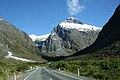
 Southeast aspect | |
| Highest point | |
| Elevation | 2,105 m (6,906 ft) [1] [2] |
| Prominence | 695 m (2,280 ft) [2] |
| Isolation | 3.06 km (1.90 mi) [2] |
| Coordinates | 44°45′03″S167°59′51″E / 44.750825°S 167.997525°E [2] |
| Naming | |
| Etymology | Arthur Ernest Talbot |
| Geography | |
 Mount Talbot Location in New Zealand | |
 | |
| Interactive map of Mount Talbot | |
| Location | South Island |
| Country | New Zealand |
| Region | Southland [2] |
| Protected area | Fiordland National Park |
| Parent range | Darran Mountains [3] |
| Topo map | Topo50 CB09 [4] |
| Geology | |
| Rock age | 136 ± 1.9 Ma |
| Rock type(s) | Gabbronorite, dioritic orthogneiss |
| Climbing | |
| First ascent | 1924 |
Mount Talbot is a 2,105-metre-elevation (6,906-foot) mountain in Fiordland, New Zealand.