The Grey River / Māwheranui is located in the northwest of the South Island of New Zealand. It rises 12 kilometres southwest of the Lewis Pass in Lake Christabel, one of numerous small lakes on the western side of the Southern Alps, and runs westward for 120 kilometres before draining into the Tasman Sea at Greymouth. Thomas Brunner, who explored the area in the late 1840s, named the river in honour of Sir George Grey, who first served as Governor of New Zealand from 1845 to 1854. The Ngāi Tahu Claims Settlement Act 1998 changed the official name of the river to Grey River / Māwheranui in 1998. The Māori name for the river system and surrounding area is Māwhera, with Māwheranui being distinguished from the northern branch Little Grey River / Māwheraiti.
Lake Christabel is a small lake in the north of New Zealand's South Island. It is located 12 kilometres southwest of the Lewis Pass. The lake is the source of the Grey River, one of the longest rivers on the South Island's West Coast, although its outlet is underground. The lake lies behind a landslide dam, thought to have been created by a prehistoric earthquake. The river runs under the debris for about 200 m (660 ft). A 1976 survey said it was, "one of the very few lakes in New Zealand in a natural, unmodified state". It estimated its depth at over 90 m (300 ft). Galaxias brevipinnis and Anquilla dieffenbachii were the only fish found.
Mount Pye is a rugged hill in the southeast of the South Island of New Zealand. It is the highest point in the area known as the Catlins, rising to 720 m (2361 ft). It is located 40 km (25 mi) southeast of Gore, and forms part of the border between the Otago and Southland regions. The headwaters of many of the Catlins' rivers are located on the slopes of Mount Pye.
Abel Lake was a small lake in the Westland region of the South Island of New Zealand. It was located in the Southern Alps, 35 kilometres (22 mi) east of Franz Josef and was fed by the Abel Glacier. A short stream linked the lake with the Perth River. The lake was was likely displaced with alluvial / glacial rock or the outlet was lowered by natural erosion or manually by gold prospectors.

Ōhinetamatea River / Saltwater Creek is a river in the Westland District of New Zealand.
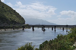
The Little Grey River, also known as the Māwheraiti is a river of the West Coast Region of New Zealand. It is a major tributary of the Grey River / Māwheranui which it joins at Ikamatua.
The Stanley River is a river of the Canterbury region of New Zealand's South Island. An upper tributary of the Waiau Uwha River, it rises on the southern flanks of the St James Range and flows southwest to reach the Waiau Uwha 17 kilometres (11 mi) east of the Lewis Pass. Lake Guyon drains to the Stanley River via a swampy tributary named Stanley Vale. In its lower reaches the river passes through a gorge known as Stanley Gate. The Fowler Pass Track follows the river for much of its length.
The Spey River is a river in the Southland Region of New Zealand. Its entire length lies within the Fiordland National Park. The Spey rises at the Mckenzie Pass and Murrell's Pass either side of Mt Horatio (1,380 metres, and the river flows in a northeasterly direction, emptying into the West Arm of Lake Manapouri adjacent to the intake of the Manapouri Power Station. The Dusky Track follows the Spey valley for much of the river's length.
The Spey River is a river in the Tasman Mountains in the northwest of the South Island of New Zealand. The river drains Lake Aorere near the Aorere Saddle, and is fed by numerous small streams draining the Gouland Range on the west and part of the Domett Range on the east. It flows north then east before joining the upper reaches of the Aorere River.
The Snow River is a river in the Tasman Region of the South Island of New Zealand. It rises at the western end of the Haupiri Range and flows northward before rounding the tip of Kill Devil Spur to join the Slate River. The Slate is a tributary of the Aorere, the major river of the northwestern Tasman region.
The Cass River is an alpine river in the Canterbury region of the South Island of New Zealand. It rises in the Hall Range immediately below Rankin Pass, and also receives water from the nearby Huxley Glacier. After dropping 600 metres (2,000 ft) very rabidly the river flows south with braided channels along a flat-bottomed valley for 25 kilometres (16 mi). The Leibig Range and Gamack Range are to the west, and the Haszard Range to the east. The river flows into the west side of Lake Tekapo where it has built up a gravel delta.
The Fork River is a short river in the far south of the West Coast Region in New Zealand. As the name suggests, the river has two branches, with the longer South branch draining a plateau. The larger Spoon River lies a couple of kilometres to the north.
Mount Edgecumbe is a mountain in the Fiordland National Park in the Southland Region of New Zealand. It is situated on the southern side of Cook Channel, an arm of Dusky Sound and is the westernmost of a small mountain range containing several higher but unnamed peaks. There is a small unnamed lake at around 800 metres on the southeastern flank of the mountain.
The Robinson River is a river in the West Coast Region of the South Island of New Zealand. It is a tributary of the Upper Grey River and much of the river lies within the Lake Sumner Conservation Park. Rising on the slopes of Mount Boscawen on the main divide about 12 kilometres (7.5 mi) south of the Lewis Pass, the river runs west-southwest along a straight, narrow valley before turning northwest to reach the Upper Grey.
Alpine Lake / Ata Puai is a small lake in the West Coast Region of New Zealand. The lake is located 6 kilometres (3.7 mi) south of Ōkārito and 4 kilometres (2.5 mi) west of the larger Lake Mapourika. "Alpine" is something of a misnomer as the lake is only 4 kilometres (2.5 mi) from the sea and at an elevation of less than 100 metres (330 ft).

The Ashburton River / Hakatere is a river in the Canterbury region of New Zealand, flowing across Mid Canterbury from the Southern Alps to the Pacific Ocean. The official name of the river was amended to become a dual name by the Ngāi Tahu Claims Settlement Act 1998. It has been identified as an Important Bird Area by BirdLife International because it supports breeding colonies of the endangered black-billed gull.
The Tiraumea River is a river of the Tasman Region of New Zealand's South Island. The river has its source on the slopes of Mount Hutton at the southern end of the Braeburn Range, and runs northwest from the Tiraumea Saddle. It reaches the Tutaki River 10 kilometres southeast of Murchison. The area is known for hunting.
The Tōtara River is a river of the northern West Coast Region of New Zealand's South Island. It rises near Mount Kelvin in the Paparoa Range and flows northwest to reach the Tasman Sea 10 kilometres south of Cape Foulwind. The Little Totara River joins the Tōtara just before it reaches the sea.
The Tōtara River is a river of the southern West Coast of New Zealand's South Island. Rising on the slopes of Bald Hill the river flows north then west to reach the Tasman Sea two kilometres north of Ross.
The Waikare River is a river in the Bay of Plenty Region of New Zealand' North Island. It flows north from its origins between the peaks of Matawhio and Papakai north of Lake Waikaremoana to reach the Whakatane River 25 kilometres (16 mi) east of Murupara.
